![](/images/other/stat-length.png)
![Excursión Senderismo Sainte-Suzanne-et-Chammes - Sainte-Suzanne - Vers la table du Diable 18 km - Photo](https://media.geolcdn.com/t/1900/400/3f664fa0-57cb-4bed-9ee6-1cd29cbbddc2.jpg&format=pjpeg&maxdim=2)
Sainte-Suzanne - Vers la table du Diable 18 km
MichelRando7656
Usuario
![Longitud](/images/other/stat-length.png)
![Boucle](https://static1.geolcdn.com/siteimages/upload/files/16400158638029165_repeat_loop_refresh_sync_direction_icon.png)
![Senderismo](https://static1.geolcdn.com/sitytour/trail-icons/101.png)
7h14
Dificultad : Muy fácil
![Escanee este código QR para abrir la excursión en la aplicación SityTrail](https://capi.geolives.com/qq0zvz2zws4bq2lad0pu/sitytour/trails/2071476/qr.png?size=200)
Aplicación GPS de excursión GRATIS
A propósito
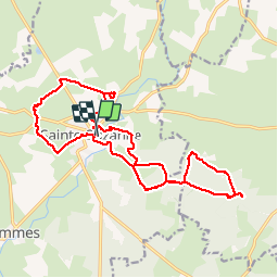
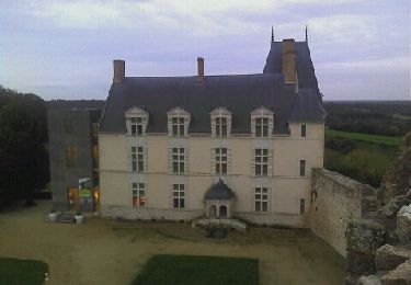
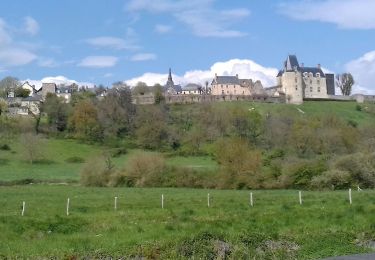
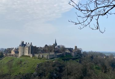
Ruta Senderismo de 18 km a descubrir en Países del Loira, Mayenne, Sainte-Suzanne-et-Chammes. Esta ruta ha sido propuesta por MichelRando7656.
Descripción
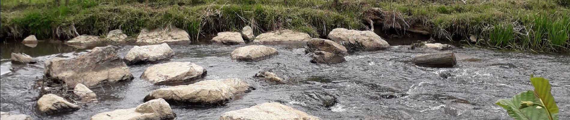
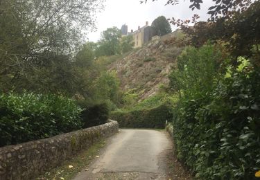
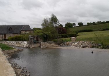
Beaux paysages à travers des sentiers herbeux. Pique-nique au bord de l'Erve sous le soleil. En suite direction la table du diable à travers une forêt de chênes. Retour à Sainte Suzanne par une rude montée sous le château.
Localización
Comentarios
Excursiones cerca
![Excursión Senderismo Sainte-Suzanne-et-Chammes - Entre Erve et Charmie Ste Suzanne 53 - Photo](https://media.geolcdn.com/t/375/260/fce38b53-75f2-481d-9646-5fe0908faad4.jpg&format=jpg&maxdim=2)
![Senderismo Senderismo](https://static1.geolcdn.com/sitytour/trail-icons/101.png)
Senderismo
![](/images/other/stat-length.png)
![](https://static1.geolcdn.com/siteimages/upload/files/16400158638029165_repeat_loop_refresh_sync_direction_icon.png)
![Excursión Senderismo Sainte-Suzanne-et-Chammes - Sainte-Suzanne - Le Moulin à papier - Chammes et retour - Photo](https://media.geolcdn.com/t/375/260/30f464ce-1bc8-43db-beaf-4e7713f66733.jpg&format=jpg&maxdim=2)
![Senderismo Senderismo](https://static1.geolcdn.com/sitytour/trail-icons/101.png)
Senderismo
![](/images/other/stat-length.png)
![](https://static1.geolcdn.com/siteimages/upload/files/16400158638029165_repeat_loop_refresh_sync_direction_icon.png)
![Excursión Senderismo Sainte-Suzanne-et-Chammes - Balade autour de Sainte Suzanne - Photo](https://media.geolcdn.com/t/375/260/ext.jpg?maxdim=2&url=https%3A%2F%2Fservices.sitytrail.com%2FGeolivesWS%2FDownloadMedia.ashx%3FTrailID%3D232340%26Media%3Dfix__20131103171133.jpg)
![Senderismo Senderismo](https://static1.geolcdn.com/sitytour/trail-icons/101.png)
Senderismo
![](/images/other/stat-length.png)
![](https://static1.geolcdn.com/siteimages/upload/files/16400158638029165_repeat_loop_refresh_sync_direction_icon.png)
![Excursión Senderismo Sainte-Suzanne-et-Chammes - Ste Suzanne Chammes - 6,5 km - Photo](https://media.geolcdn.com/t/375/260/37ab4376-4983-488b-b50e-1bf8448d121e.jpg&format=jpg&maxdim=2)
![Senderismo Senderismo](https://static1.geolcdn.com/sitytour/trail-icons/101.png)
Senderismo
![](/images/other/stat-length.png)
![](https://static1.geolcdn.com/siteimages/upload/files/16400158638029165_repeat_loop_refresh_sync_direction_icon.png)
![Excursión Senderismo Sainte-Suzanne-et-Chammes - St Suzanne - Photo](https://media.geolcdn.com/t/375/260/27b7f385-add3-4f07-8cb2-61a78851858d.jpg&format=jpg&maxdim=2)
![Senderismo Senderismo](https://static1.geolcdn.com/sitytour/trail-icons/101.png)
Senderismo
![](/images/other/stat-length.png)
![](https://static1.geolcdn.com/siteimages/upload/files/16400158638029165_repeat_loop_refresh_sync_direction_icon.png)
![Excursión Bici de montaña Sainte-Suzanne-et-Chammes - ste Suzanne Charmes. - Photo](https://media.geolcdn.com/t/375/260/ext.jpg?maxdim=2&url=https%3A%2F%2Fstatic1.geolcdn.com%2Fsiteimages%2Fupload%2Ffiles%2F1524743154velo.jpg)
![Bici de montaña Bici de montaña](https://static1.geolcdn.com/sitytour/trail-icons/202.png)
Bici de montaña
![](/images/other/stat-length.png)
![](https://static1.geolcdn.com/siteimages/upload/files/16400158638029165_repeat_loop_refresh_sync_direction_icon.png)
![Excursión Paseo ecuestre Sainte-Suzanne-et-Chammes - grte mayenne jour 2 - Photo](https://media.geolcdn.com/t/375/260/ext.jpg?maxdim=2&url=https%3A%2F%2Fstatic1.geolcdn.com%2Fsiteimages%2Fupload%2Ffiles%2F1524743154cheval.jpg)
![Paseo ecuestre Paseo ecuestre](https://static1.geolcdn.com/sitytour/trail-icons/301.png)
Paseo ecuestre
![](/images/other/stat-length.png)
![](https://static1.geolcdn.com/siteimages/upload/files/16400158638029165_repeat_loop_refresh_sync_direction_icon.png)
![Excursión Bici de montaña Sainte-Suzanne-et-Chammes - Sainte Suzanne/Torcé-Vivier - Photo](https://media.geolcdn.com/t/375/260/ext.jpg?maxdim=2&url=https%3A%2F%2Fstatic1.geolcdn.com%2Fsiteimages%2Fupload%2Ffiles%2F1524743154velo.jpg)
![Bici de montaña Bici de montaña](https://static1.geolcdn.com/sitytour/trail-icons/202.png)
Bici de montaña
![](/images/other/stat-length.png)
![](https://static1.geolcdn.com/siteimages/upload/files/16400158638029165_repeat_loop_refresh_sync_direction_icon.png)
![Excursión Senderismo Sainte-Suzanne-et-Chammes - Sainte Suzanne de Chamme - Photo](https://media.geolcdn.com/t/375/260/987a8781-3c0c-46b3-9f22-9674752804a4.jpg&format=jpg&maxdim=2)
![Senderismo Senderismo](https://static1.geolcdn.com/sitytour/trail-icons/101.png)
Senderismo
![](/images/other/stat-length.png)
![](https://static1.geolcdn.com/siteimages/upload/files/16400158638029165_repeat_loop_refresh_sync_direction_icon.png)