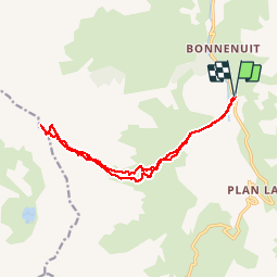
![](/images/other/stat-length.png)
![Excursión Esquí de fondo Valloire - Aiguille d'Argentière - Photo](https://media.geolcdn.com/t/1900/400/368b8c74-1c62-4177-b4ab-009e37bbbea9.jpg&format=pjpeg&maxdim=2)
Aiguille d'Argentière
nadd73
Usuario GUIDE
![Longitud](/images/other/stat-length.png)
![Altitud máxima](https://static1.geolcdn.com/siteimages/upload/files/1508320355ic_sort_altitude_max_24dp.png)
![Desnivel positivo](https://static1.geolcdn.com/siteimages/upload/files/1508320355ic_sort_den_pos_24dp.png)
![Km-Effort](/images/other/stat-length.png)
![Altitud mínima](https://static1.geolcdn.com/siteimages/upload/files/1508320355ic_sort_altitude_min_24dp.png)
![Desnivel negativo](https://static1.geolcdn.com/siteimages/upload/files/1508320355ic_sort_den_neg_24dp.png)
![Boucle](https://static1.geolcdn.com/siteimages/upload/files/16400158638029165_repeat_loop_refresh_sync_direction_icon.png)
![Esquí de fondo](https://static1.geolcdn.com/sitytour/trail-icons/503.png)
8h00
Dificultad : Difícil
![Escanee este código QR para abrir la excursión en la aplicación SityTrail](https://capi.geolives.com/qq0zvz2zws4bq2lad0pu/sitytour/trails/2070133/qr.png?size=200)
Aplicación GPS de excursión GRATIS
A propósito
Ruta Esquí de fondo de 14,9 km a descubrir en Auvergne-Rhône-Alpes, Saboya, Valloire. Esta ruta ha sido propuesta por nadd73.
Descripción
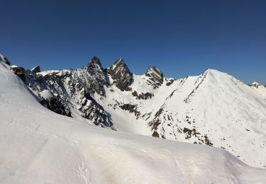
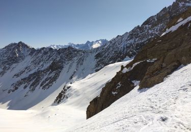
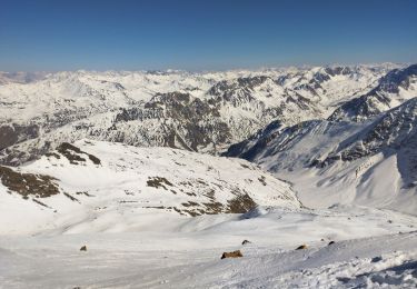
Départ de la petite Charmette, descendre 40m pour traverser la passerelle et monter dans la combe de mortavieille.
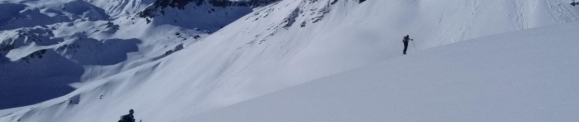
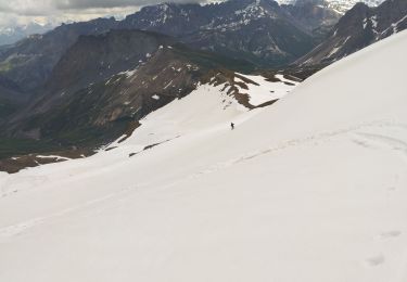
Ensuite passer au dessus du rocher Belin pour continuer dans la combe du Goléon. Tirer à droite pour monter sur l'arête vers 3000m continuer celle ci jusqu'au sommet.
Descente idem ou pour les costauds dans la face Est.
Localización
Comentarios
Excursiones cerca
![Excursión Senderismo Valloire - Le Pic de l'Aigle (ou presque), 2776m - Photo](https://media.geolcdn.com/t/375/260/ext.jpg?maxdim=2&url=https%3A%2F%2Fservices.sitytrail.com%2FGeolivesWS%2FDownloadMedia.ashx%3FTrailID%3D107289%26Media%3D12175_1.jpg)
![Senderismo Senderismo](https://static1.geolcdn.com/sitytour/trail-icons/101.png)
Senderismo
![](/images/other/stat-length.png)
![](https://static1.geolcdn.com/siteimages/upload/files/16400158638029165_repeat_loop_refresh_sync_direction_icon.png)
![Excursión Senderismo Valloire - GPX Download: Boucle Vue sur le lac de Cerces – Lac des Cerces au départ de Moulin Benjamin - Photo](https://media.geolcdn.com/t/375/260/ext.jpg?maxdim=2&url=https%3A%2F%2Fstatic1.geolcdn.com%2Fsiteimages%2Fupload%2Ffiles%2F1553511878bg_sport_marche.png)
![Senderismo Senderismo](https://static1.geolcdn.com/sitytour/trail-icons/101.png)
Senderismo
![](/images/other/stat-length.png)
![](https://static1.geolcdn.com/siteimages/upload/files/16400158638029165_repeat_loop_refresh_sync_direction_icon.png)
![Excursión Esquí de fondo Valloire - Tricotage pic blanc du Galibier, petit Galibier ouest.. - Photo](https://media.geolcdn.com/t/375/260/5fb80036-d061-47ea-be50-06ae2f510eef.jpg&format=jpg&maxdim=2)
![Esquí de fondo Esquí de fondo](https://static1.geolcdn.com/sitytour/trail-icons/503.png)
Esquí de fondo
![](/images/other/stat-length.png)
![](https://static1.geolcdn.com/siteimages/upload/files/16400158638029165_repeat_loop_refresh_sync_direction_icon.png)
![Excursión Senderismo Valloire - le grand Galibier par le plan lachat - Photo](https://media.geolcdn.com/t/375/260/ext.jpg?maxdim=2&url=https%3A%2F%2Fservices.sitytrail.com%2FGeolivesWS%2FDownloadMedia.ashx%3FTrailID%3D464698%26Media%3D82d2ca84-ebcc-4d20-9f14-0e6afb40d51f.JPG)
![Senderismo Senderismo](https://static1.geolcdn.com/sitytour/trail-icons/101.png)
Senderismo
![](/images/other/stat-length.png)
![](https://static1.geolcdn.com/siteimages/upload/files/16400158638029165_repeat_loop_refresh_sync_direction_icon.png)
![Excursión Esquí de fondo Valloire - PT 2973 sur la crête d'argentière - Photo](https://media.geolcdn.com/t/375/260/9dd54d7b-14b1-43db-b5e7-f165732d35b0.jpg&format=jpg&maxdim=2)
![Esquí de fondo Esquí de fondo](https://static1.geolcdn.com/sitytour/trail-icons/503.png)
Esquí de fondo
![](/images/other/stat-length.png)
![](https://static1.geolcdn.com/siteimages/upload/files/16400158638029165_repeat_loop_refresh_sync_direction_icon.png)
![Excursión Esquí de fondo Valloire - Col de petit Jean - Photo](https://media.geolcdn.com/t/375/260/e1f50793-9675-4ea6-9a1c-3ba4e20102bf.jpg&format=jpg&maxdim=2)
![Esquí de fondo Esquí de fondo](https://static1.geolcdn.com/sitytour/trail-icons/503.png)
Esquí de fondo
![](/images/other/stat-length.png)
![](https://static1.geolcdn.com/siteimages/upload/files/16400158638029165_repeat_loop_refresh_sync_direction_icon.png)
![Excursión Esquí de fondo Valloire - Aiguille de l'épaisseur - Photo](https://media.geolcdn.com/t/375/260/77d61587-180b-4205-b36d-a83a35e6850c.jpg&format=jpg&maxdim=2)
![Esquí de fondo Esquí de fondo](https://static1.geolcdn.com/sitytour/trail-icons/503.png)
Esquí de fondo
![](/images/other/stat-length.png)
![](https://static1.geolcdn.com/siteimages/upload/files/16400158638029165_repeat_loop_refresh_sync_direction_icon.png)
![Excursión Senderismo Valloire - Bonne nuit- refuge - combe des Aiguilles - Photo](https://media.geolcdn.com/t/375/260/324355e1-ed1e-44dd-bc99-5afcf7d1c974.jpg&format=jpg&maxdim=2)
![Senderismo Senderismo](https://static1.geolcdn.com/sitytour/trail-icons/101.png)
Senderismo
![](/images/other/stat-length.png)
![](https://static1.geolcdn.com/siteimages/upload/files/16400158638029165_repeat_loop_refresh_sync_direction_icon.png)
![Excursión Esquí de fondo Valloire - le petit Galibier et le Pic blanc du Galibier - Photo](https://media.geolcdn.com/t/375/260/13e5b259-248b-4414-b2ce-a9ffa155710d.jpg&format=jpg&maxdim=2)
![Esquí de fondo Esquí de fondo](https://static1.geolcdn.com/sitytour/trail-icons/503.png)
Esquí de fondo
![](/images/other/stat-length.png)
![](https://static1.geolcdn.com/siteimages/upload/files/16400158638029165_repeat_loop_refresh_sync_direction_icon.png)