![](/images/other/stat-length.png)
![Excursión Senderismo Mirabel-et-Blacons - Le Val de Charsac - Photo](https://media.geolcdn.com/t/1900/400/b592012e-186b-4879-b446-b5e5553d6dad.jpg&format=pjpeg&maxdim=2)
Le Val de Charsac
Philindy26
Usuario
![Longitud](/images/other/stat-length.png)
![Altitud máxima](https://static1.geolcdn.com/siteimages/upload/files/1508320355ic_sort_altitude_max_24dp.png)
![Desnivel positivo](https://static1.geolcdn.com/siteimages/upload/files/1508320355ic_sort_den_pos_24dp.png)
![Km-Effort](/images/other/stat-length.png)
![Altitud mínima](https://static1.geolcdn.com/siteimages/upload/files/1508320355ic_sort_altitude_min_24dp.png)
![Desnivel negativo](https://static1.geolcdn.com/siteimages/upload/files/1508320355ic_sort_den_neg_24dp.png)
![Boucle](https://static1.geolcdn.com/siteimages/upload/files/16400158638029165_repeat_loop_refresh_sync_direction_icon.png)
![Senderismo](https://static1.geolcdn.com/sitytour/trail-icons/101.png)
5h40
Dificultad : Difícil
![Escanee este código QR para abrir la excursión en la aplicación SityTrail](https://capi.geolives.com/qq0zvz2zws4bq2lad0pu/sitytour/trails/2067856/qr.png?size=200)
Aplicación GPS de excursión GRATIS
A propósito
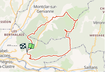
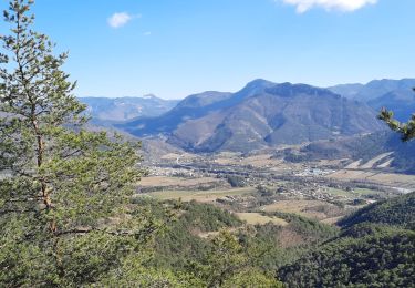
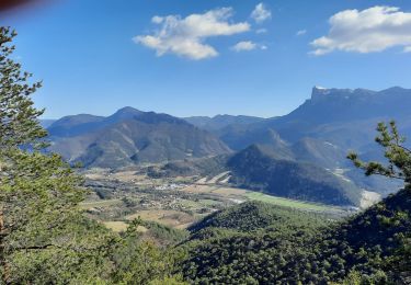
Ruta Senderismo de 18,8 km a descubrir en Auvergne-Rhône-Alpes, Drôme, Mirabel-et-Blacons. Esta ruta ha sido propuesta por Philindy26.
Descripción
Départ chemin de Sauzet, au bord de la D617, commune de Mirabel-et-Blacons (250 m)...
Géolocalisation (Google Maps) : https://goo.gl/maps/1hEeWjYsJKKdy9md6 .
Suivre la D617 au Sud, puis prendre le chemin de Sans Souci, passez le hameau puis suivre à droite un sentier qui vous emmènera sur les crêtes (suivre marque jaune).
Au Serre Peyplat (500 m) direction le col de Sauzet et le col de Pourcheton (610 m). Puis rejoindre le Serre des Trois Bornes (660 m). Là rejoindre la Chapelle Saint-Christophe (559 m) par le col de la Tuilerie (576 m).
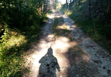
Retour par le chemin des Bélardes (ravin de Bergoule); Après environ 1 Km prendre un sentier à droite qui traversera le ruisseau de Charsac.
A la piste des Bélardes, prendre direction Piégros-la-Clastre, marque Jaune/Rouge, rejoindre le col de la Boite (419 m), traversée la D617, direction le col de l'Armurier (396 m). Puis retour sur la D617 que vous suivrez jusqu'au Cheylard (265 m) et le chemin de Sauzet.
Localización
Comentarios
Excursiones cerca
![Senderismo Senderismo](https://static1.geolcdn.com/sitytour/trail-icons/101.png)
Senderismo
![](/images/other/stat-length.png)
![](https://static1.geolcdn.com/siteimages/upload/files/16400158638029165_repeat_loop_refresh_sync_direction_icon.png)
![Excursión Senderismo Piégros-la-Clastre - Pas de Lauzen Col de la Chaudière - Photo](https://media.geolcdn.com/t/375/260/ext.jpg?maxdim=2&url=https%3A%2F%2Fservices.sitytrail.com%2FGeolivesWS%2FDownloadMedia.ashx%3FTrailID%3D141403%26Media%3D20120724110938.jpeg)
![Senderismo Senderismo](https://static1.geolcdn.com/sitytour/trail-icons/101.png)
Senderismo
![](/images/other/stat-length.png)
![](https://static1.geolcdn.com/siteimages/upload/files/16400158638029165_repeat_loop_refresh_sync_direction_icon.png)
![Excursión Senderismo Montclar-sur-Gervanne - Montclar sur Gervanne-Col Gerbe-Chple St Christophe 17km - Photo](https://media.geolcdn.com/t/375/260/1c8b8899-04e8-4a27-b14a-14d516682923.jpg&format=jpg&maxdim=2)
![Senderismo Senderismo](https://static1.geolcdn.com/sitytour/trail-icons/101.png)
Senderismo
![](/images/other/stat-length.png)
![](https://static1.geolcdn.com/siteimages/upload/files/16400158638029165_repeat_loop_refresh_sync_direction_icon.png)
![Excursión Senderismo Montclar-sur-Gervanne - 2023-02-26_18h25m27_Montclar sur Gervanne 16km - Photo](https://media.geolcdn.com/t/375/260/ebf5c7b8-3682-4aaf-a165-5eb68ffb7b11.jpg&format=jpg&maxdim=2)
![Senderismo Senderismo](https://static1.geolcdn.com/sitytour/trail-icons/101.png)
Senderismo
![](/images/other/stat-length.png)
![](https://static1.geolcdn.com/siteimages/upload/files/16400158638029165_repeat_loop_refresh_sync_direction_icon.png)
![Excursión Senderismo Piégros-la-Clastre - cht de Piegros, chap de Médard - Photo](https://media.geolcdn.com/t/375/260/9cd8a646-1714-40d6-bd7d-290d8ba4a2e6.jpg&format=jpg&maxdim=2)
![Senderismo Senderismo](https://static1.geolcdn.com/sitytour/trail-icons/101.png)
Senderismo
![](/images/other/stat-length.png)
![](https://static1.geolcdn.com/siteimages/upload/files/16400158638029165_repeat_loop_refresh_sync_direction_icon.png)
![Excursión Senderismo Mirabel-et-Blacons - Mirabel et Balcons de la Drôme 16 km - Photo](https://media.geolcdn.com/t/375/260/963acc32-6a93-45d3-af60-bd090da1d225.jpg&format=jpg&maxdim=2)
![Senderismo Senderismo](https://static1.geolcdn.com/sitytour/trail-icons/101.png)
Senderismo
![](/images/other/stat-length.png)
![](https://static1.geolcdn.com/siteimages/upload/files/16400158638029165_repeat_loop_refresh_sync_direction_icon.png)
![Excursión Senderismo Mirabel-et-Blacons - Mirabel et Balcons de La Drôme 18km - Photo](https://media.geolcdn.com/t/375/260/7ccb2739-851d-4c67-a22e-9a9b8b7642c6.jpg&format=jpg&maxdim=2)
![Senderismo Senderismo](https://static1.geolcdn.com/sitytour/trail-icons/101.png)
Senderismo
![](/images/other/stat-length.png)
![](https://static1.geolcdn.com/siteimages/upload/files/16400158638029165_repeat_loop_refresh_sync_direction_icon.png)
![Excursión Senderismo Mirabel-et-Blacons - Col de Pourcheton - Photo](https://media.geolcdn.com/t/375/260/29397ae2-1f83-4231-8d6d-5acd5ad8814a.jpg&format=jpg&maxdim=2)
![Senderismo Senderismo](https://static1.geolcdn.com/sitytour/trail-icons/101.png)
Senderismo
![](/images/other/stat-length.png)
![](https://static1.geolcdn.com/siteimages/upload/files/16400158638029165_repeat_loop_refresh_sync_direction_icon.png)
![Excursión Senderismo Mirabel-et-Blacons - Le vieux Mirabel - Photo](https://media.geolcdn.com/t/375/260/6283c72e-165b-49ca-8460-8f24dc97a5b9.jpg&format=jpg&maxdim=2)
![Senderismo Senderismo](https://static1.geolcdn.com/sitytour/trail-icons/101.png)
Senderismo
![](/images/other/stat-length.png)
![](https://static1.geolcdn.com/siteimages/upload/files/16400158638029165_repeat_loop_refresh_sync_direction_icon.png)