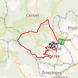
![](/images/other/stat-length.png)
![Excursión Senderismo Jullié - Jullié (16 km - D. 483 m) le 11/03/2019 - Photo](https://media.geolcdn.com/t/1900/400/2b11bd4b-33a1-400f-bbc3-0e2c5456345c.jpg&format=pjpeg&maxdim=2)
Jullié (16 km - D. 483 m) le 11/03/2019
Thomasdanielle
Usuario
![Longitud](/images/other/stat-length.png)
![Altitud máxima](https://static1.geolcdn.com/siteimages/upload/files/1508320355ic_sort_altitude_max_24dp.png)
![Desnivel positivo](https://static1.geolcdn.com/siteimages/upload/files/1508320355ic_sort_den_pos_24dp.png)
![Km-Effort](/images/other/stat-length.png)
![Altitud mínima](https://static1.geolcdn.com/siteimages/upload/files/1508320355ic_sort_altitude_min_24dp.png)
![Desnivel negativo](https://static1.geolcdn.com/siteimages/upload/files/1508320355ic_sort_den_neg_24dp.png)
![Boucle](https://static1.geolcdn.com/siteimages/upload/files/16400158638029165_repeat_loop_refresh_sync_direction_icon.png)
![Senderismo](https://static1.geolcdn.com/sitytour/trail-icons/101.png)
4h47
Dificultad : Fácil
![Escanee este código QR para abrir la excursión en la aplicación SityTrail](https://capi.geolives.com/qq0zvz2zws4bq2lad0pu/sitytour/trails/2046068/qr.png?size=200)
Aplicación GPS de excursión GRATIS
A propósito
Ruta Senderismo de 16 km a descubrir en Auvergne-Rhône-Alpes, Ródano, Jullié. Esta ruta ha sido propuesta por Thomasdanielle.
Descripción
D/A Parking au centre du village "Monuments aux morts"
Suivre les panneau "Le HOUX"
Pour démarrer la randonnée, traverser la route en face du parking puis descendre sur la droite en direction du lavoir, prendre à droite le sentier le long des maisons. Continuer pour rejoindre beaucoup plus haut la route.
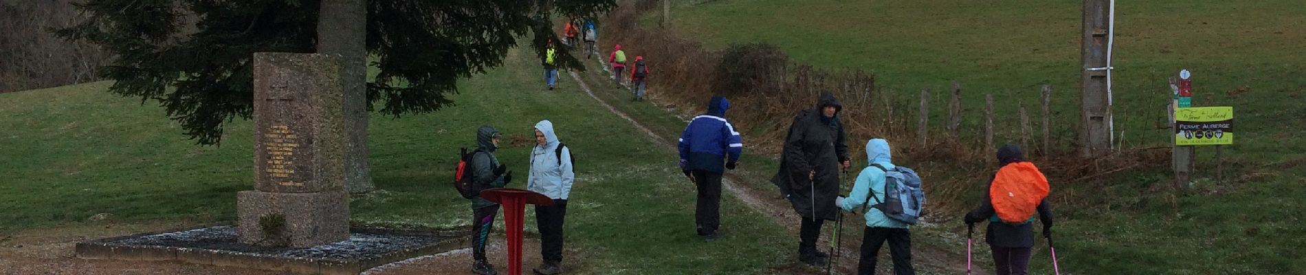
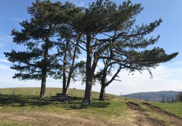
Pique-nique à la cabane (table et bancs) au col de Sibérie qui porte bien son nom vu le froid que nous avons eu ce jour là, le 11/03/2019
Puis continuer jusqu'au "Les roches" et reprendre "les Houx" le n° 6
Localización
Comentarios
Excursiones cerca
![Excursión Senderismo Vauxrenard - Itinérant Beaujolais rouge étape 6 Foretal - Macon gare TGV - Photo](https://media.geolcdn.com/t/375/260/413cab1b-506e-4c3e-962c-5987ea1a88f6.jpg&format=jpg&maxdim=2)
![Senderismo Senderismo](https://static1.geolcdn.com/sitytour/trail-icons/101.png)
Senderismo
![](/images/other/stat-length.png)
![](https://static1.geolcdn.com/siteimages/upload/files/16400158638029165_repeat_loop_refresh_sync_direction_icon.png)
![Excursión Senderismo Vauxrenard - vauxrenard - Photo](https://media.geolcdn.com/t/375/260/ext.jpg?maxdim=2&url=https%3A%2F%2Fstatic1.geolcdn.com%2Fsiteimages%2Fupload%2Ffiles%2F1553511878bg_sport_marche.png)
![Senderismo Senderismo](https://static1.geolcdn.com/sitytour/trail-icons/101.png)
Senderismo
![](/images/other/stat-length.png)
![](https://static1.geolcdn.com/siteimages/upload/files/16400158638029165_repeat_loop_refresh_sync_direction_icon.png)
![Excursión Senderismo Chénas - Chénas - Le Venet - Photo](https://media.geolcdn.com/t/375/260/d8ea6745-554d-47dd-be4a-fb50b3697e17.jpeg&format=jpg&maxdim=2)
![Senderismo Senderismo](https://static1.geolcdn.com/sitytour/trail-icons/101.png)
Senderismo
![](/images/other/stat-length.png)
![](https://static1.geolcdn.com/siteimages/upload/files/16400158638029165_repeat_loop_refresh_sync_direction_icon.png)
![Excursión Senderismo Leynes - LEYNES 71 - Photo](https://media.geolcdn.com/t/375/260/61b56629-d697-45a7-bb0d-bd0fe620434d.jpg&format=jpg&maxdim=2)
![Senderismo Senderismo](https://static1.geolcdn.com/sitytour/trail-icons/101.png)
Senderismo
![](/images/other/stat-length.png)
![](https://static1.geolcdn.com/siteimages/upload/files/16400158638029165_repeat_loop_refresh_sync_direction_icon.png)
![Excursión Senderismo Cenves - cenves la madone - Photo](https://media.geolcdn.com/t/375/260/a381df5f-0cf9-4146-a04a-b176620d4d7d.jpg&format=jpg&maxdim=2)
![Senderismo Senderismo](https://static1.geolcdn.com/sitytour/trail-icons/101.png)
Senderismo
![](/images/other/stat-length.png)
![](https://static1.geolcdn.com/siteimages/upload/files/16400158638029165_repeat_loop_refresh_sync_direction_icon.png)
![Excursión Senderismo Chasselas - Chasselas (Saône- et-Loire région Bourgogne) - Photo](https://media.geolcdn.com/t/375/260/a1e39a90-d3b1-40f6-b80a-42d8086a07ac.jpg&format=jpg&maxdim=2)
![Senderismo Senderismo](https://static1.geolcdn.com/sitytour/trail-icons/101.png)
Senderismo
![](/images/other/stat-length.png)
![](https://static1.geolcdn.com/siteimages/upload/files/16400158638029165_repeat_loop_refresh_sync_direction_icon.png)
![Excursión Senderismo Cenves - Cenves](https://media.geolcdn.com/t/375/260/e37d4c40-86a6-4702-8656-51d1279bf78a.jpeg&format=jpg&maxdim=2)
![Senderismo Senderismo](https://static1.geolcdn.com/sitytour/trail-icons/101.png)
Senderismo
![](/images/other/stat-length.png)
![](https://static1.geolcdn.com/siteimages/upload/files/16400158638029165_repeat_loop_refresh_sync_direction_icon.png)
![Excursión Carrera Juliénas - jour 1 CAP Jeanot - Photo](https://media.geolcdn.com/t/375/260/13a91d92-1c30-4881-aeb7-c1c040badea9.jpg&format=jpg&maxdim=2)
![Carrera Carrera](https://static1.geolcdn.com/sitytour/trail-icons/103.png)
Carrera
![](/images/other/stat-length.png)
![](https://static1.geolcdn.com/siteimages/upload/files/16400158638029165_repeat_loop_refresh_sync_direction_icon.png)
![Excursión Senderismo Chénas - Chenas - Le Venet (2) - Photo](https://media.geolcdn.com/t/375/260/84362a50-f819-4345-99da-3ae671607f38.jpeg&format=jpg&maxdim=2)
![Senderismo Senderismo](https://static1.geolcdn.com/sitytour/trail-icons/101.png)
Senderismo
![](/images/other/stat-length.png)
![](https://static1.geolcdn.com/siteimages/upload/files/16400158638029165_repeat_loop_refresh_sync_direction_icon.png)
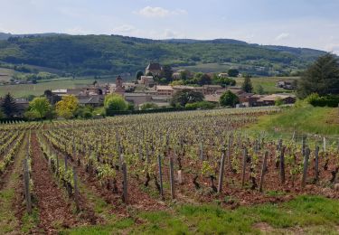
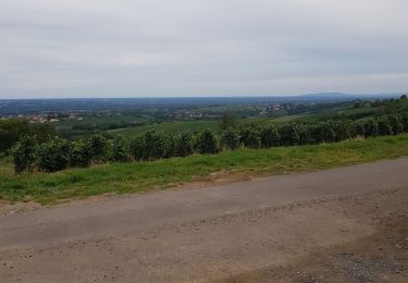
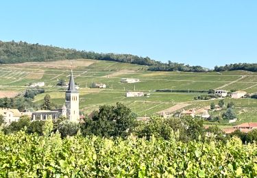
Beau parcours, avec de jolis paysages.