![](/images/other/stat-length.png)
![Excursión Senderismo Embrun - Tour du Roc Embrun - Photo](https://media.geolcdn.com/t/1900/400/d2bb0f2f-f84b-41b2-ac5a-83eb65d47d60.jpg&format=pjpeg&maxdim=2)
Tour du Roc Embrun
gildascb
Usuario
![Longitud](/images/other/stat-length.png)
![Altitud máxima](https://static1.geolcdn.com/siteimages/upload/files/1508320355ic_sort_altitude_max_24dp.png)
![Desnivel positivo](https://static1.geolcdn.com/siteimages/upload/files/1508320355ic_sort_den_pos_24dp.png)
![Km-Effort](/images/other/stat-length.png)
![Altitud mínima](https://static1.geolcdn.com/siteimages/upload/files/1508320355ic_sort_altitude_min_24dp.png)
![Desnivel negativo](https://static1.geolcdn.com/siteimages/upload/files/1508320355ic_sort_den_neg_24dp.png)
![Boucle](https://static1.geolcdn.com/siteimages/upload/files/16400158638029165_repeat_loop_refresh_sync_direction_icon.png)
![Senderismo](https://static1.geolcdn.com/sitytour/trail-icons/101.png)
57m
Dificultad : Muy fácil
![Escanee este código QR para abrir la excursión en la aplicación SityTrail](https://capi.geolives.com/qq0zvz2zws4bq2lad0pu/sitytour/trails/2044531/qr.png?size=200)
Aplicación GPS de excursión GRATIS
A propósito
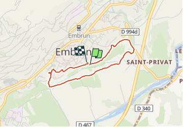
Ruta Senderismo de 3,1 km a descubrir en Provenza-Alpes-Costa Azul, Altos Alpes, Embrun. Esta ruta ha sido propuesta por gildascb.
Descripción
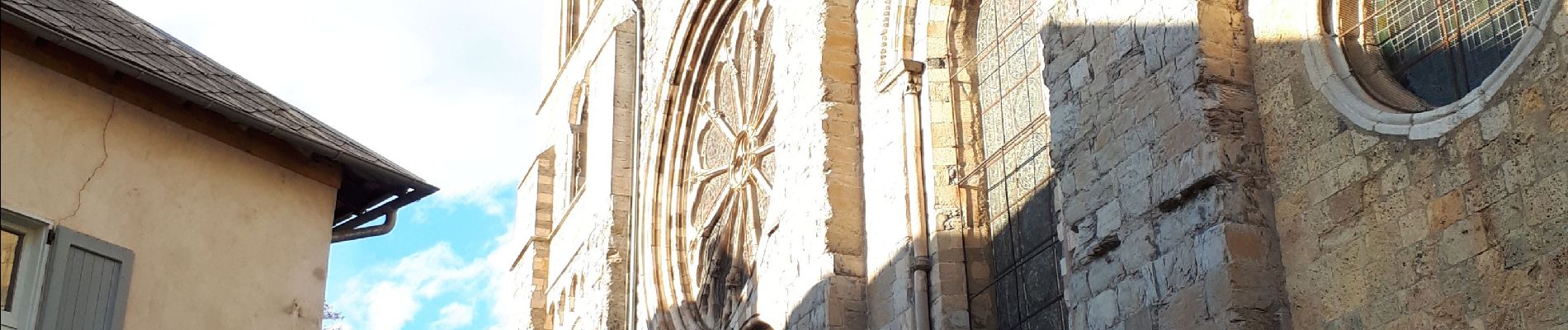
Une autre façon de découvrir Embrun. Balade sur le roc depuis le belvédère, puis sous le roc avec ses jardins et ses canaux, avant de terminer la boucle sur Embrun en passant par la cathédrale et le jardin de l'archevêché.
Pour rappel, la ville d'Embrun est juchée sur son roc, un oppidum en surplomb sur la Durance. Sur le roc, les jardins de l'archevêché desquels on peut observer la Plaine du Roc, les aménagements du plan d'eau d'Embrun, mais aussi les sommets environnants :
- le Mont Orel,
- le Mont Méale,
- le clocher de Saint-Sauveur,
- la station des Orres,
- la tête de la Mazelières
et bien sûr le Morgon qui surplombe le lac de Serre-Ponçon.
Trois tables d'orientation, offertes il y a fort longtemps par la Direction de la Construction et Armes Navales de Toulon, permettent de se repérer.
Localización
Comentarios
Excursiones cerca
![Excursión Senderismo Embrun - Lac de l'Hivernet - Photo](https://media.geolcdn.com/t/375/260/ext.jpg?maxdim=2&url=https%3A%2F%2Fservices.sitytrail.com%2FGeolivesWS%2FDownloadMedia.ashx%3FTrailID%3D1027861%26Media%3Dfix__20180818122123.jpg)
![Senderismo Senderismo](https://static1.geolcdn.com/sitytour/trail-icons/101.png)
Senderismo
![](/images/other/stat-length.png)
![](https://static1.geolcdn.com/siteimages/upload/files/16400158638029165_repeat_loop_refresh_sync_direction_icon.png)
![Excursión Senderismo Embrun - Mont Guillaume-Col de Chanté Perdrix-Lac de l'Hivernet(07-09-16) - Photo](https://media.geolcdn.com/t/375/260/ext.jpg?maxdim=2&url=https%3A%2F%2Fservices.sitytrail.com%2FGeolivesWS%2FDownloadMedia.ashx%3FTrailID%3D594349%26Media%3Dfix__20160707110131.jpg)
![Senderismo Senderismo](https://static1.geolcdn.com/sitytour/trail-icons/101.png)
Senderismo
![](/images/other/stat-length.png)
![](https://static1.geolcdn.com/siteimages/upload/files/16400158638029165_repeat_loop_refresh_sync_direction_icon.png)
![Excursión Senderismo Saint-Sauveur - 2012-08-07 Méale - Photo](https://media.geolcdn.com/t/375/260/ext.jpg?maxdim=2&url=https%3A%2F%2Fservices.sitytrail.com%2FGeolivesWS%2FDownloadMedia.ashx%3FTrailID%3D145125%26Media%3D8f8ba6a5-bed5-4779-b0c7-5d5fa06c0aa0.jpeg)
![Senderismo Senderismo](https://static1.geolcdn.com/sitytour/trail-icons/101.png)
Senderismo
![](/images/other/stat-length.png)
![](https://static1.geolcdn.com/siteimages/upload/files/16400158638029165_repeat_loop_refresh_sync_direction_icon.png)
![Excursión Senderismo Embrun - Mont Guillaume - Col de Trempa-Latz - 2671 - 10/09/23 - Photo](https://media.geolcdn.com/t/375/260/a1ad9c13-09fc-4e7a-a956-c96541f21c7a.jpg&format=jpg&maxdim=2)
![Senderismo Senderismo](https://static1.geolcdn.com/sitytour/trail-icons/101.png)
Senderismo
![](/images/other/stat-length.png)
![](https://static1.geolcdn.com/siteimages/upload/files/16400158638029165_repeat_loop_refresh_sync_direction_icon.png)
![Excursión Senderismo Embrun - Mont Guillaume - Photo](https://media.geolcdn.com/t/375/260/8a5a6651-8a6c-4528-b5ff-78962c8c835d.jpg&format=jpg&maxdim=2)
![Senderismo Senderismo](https://static1.geolcdn.com/sitytour/trail-icons/101.png)
Senderismo
![](/images/other/stat-length.png)
![](https://static1.geolcdn.com/siteimages/upload/files/16400158638029165_repeat_loop_refresh_sync_direction_icon.png)
![Excursión Senderismo Embrun - Mt Guillaume - Lac de l'Hivernet - Photo](https://media.geolcdn.com/t/375/260/cbed6be4-74aa-4976-902e-a579816616cf.jpg&format=jpg&maxdim=2)
![Senderismo Senderismo](https://static1.geolcdn.com/sitytour/trail-icons/101.png)
Senderismo
![](/images/other/stat-length.png)
![](https://static1.geolcdn.com/siteimages/upload/files/16400158638029165_repeat_loop_refresh_sync_direction_icon.png)
![Excursión Senderismo Embrun - lac de l hivernet - Photo](https://media.geolcdn.com/t/375/260/544b0507-fa9b-4776-945d-9f01d5a68a38.jpg&format=jpg&maxdim=2)
![Senderismo Senderismo](https://static1.geolcdn.com/sitytour/trail-icons/101.png)
Senderismo
![](/images/other/stat-length.png)
![](https://static1.geolcdn.com/siteimages/upload/files/16400158638029165_repeat_loop_refresh_sync_direction_icon.png)
![Excursión Senderismo Embrun - Embrun - 3.4km 90m 1h00 - 2018 06 26 - privé - Photo](https://media.geolcdn.com/t/375/260/ext.jpg?maxdim=2&url=https%3A%2F%2Fservices.sitytrail.com%2FGeolivesWS%2FDownloadMedia.ashx%3FTrailID%3D999315%26Media%3Dfix__20180626102346.jpg)
![Senderismo Senderismo](https://static1.geolcdn.com/sitytour/trail-icons/101.png)
Senderismo
![](/images/other/stat-length.png)
![](https://static1.geolcdn.com/siteimages/upload/files/16400158638029165_repeat_loop_refresh_sync_direction_icon.png)
![Excursión Senderismo Embrun - embrun - Photo](https://media.geolcdn.com/t/375/260/983747e0-b406-4f08-9e49-4a70208cddfc.jpg&format=jpg&maxdim=2)
![Senderismo Senderismo](https://static1.geolcdn.com/sitytour/trail-icons/101.png)
Senderismo
![](/images/other/stat-length.png)
![](https://static1.geolcdn.com/siteimages/upload/files/16400158638029165_repeat_loop_refresh_sync_direction_icon.png)