![](/images/other/stat-length.png)
![Excursión Senderismo Amberes - Wildernissen - Photo](https://media.geolcdn.com/t/1900/400/ext.pjpeg?maxdim=2&url=https%3A%2F%2Fstatic1.geolcdn.com%2Fsiteimages%2Fupload%2Ffiles%2F1553511878bg_sport_marche.png)
Wildernissen
speedybike
Usuario
![Longitud](/images/other/stat-length.png)
![Altitud máxima](https://static1.geolcdn.com/siteimages/upload/files/1508320355ic_sort_altitude_max_24dp.png)
![Desnivel positivo](https://static1.geolcdn.com/siteimages/upload/files/1508320355ic_sort_den_pos_24dp.png)
![Km-Effort](/images/other/stat-length.png)
![Altitud mínima](https://static1.geolcdn.com/siteimages/upload/files/1508320355ic_sort_altitude_min_24dp.png)
![Desnivel negativo](https://static1.geolcdn.com/siteimages/upload/files/1508320355ic_sort_den_neg_24dp.png)
![Boucle](https://static1.geolcdn.com/siteimages/upload/files/16400158638029165_repeat_loop_refresh_sync_direction_icon.png)
![Senderismo](https://static1.geolcdn.com/sitytour/trail-icons/101.png)
1h32
Dificultad : Medio
![Escanee este código QR para abrir la excursión en la aplicación SityTrail](https://capi.geolives.com/qq0zvz2zws4bq2lad0pu/sitytour/trails/204412/qr.png?size=200)
Aplicación GPS de excursión GRATIS
A propósito
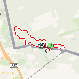
Ruta Senderismo de 6,4 km a descubrir en Flandes, Amberes, Amberes. Esta ruta ha sido propuesta por speedybike.
Descripción
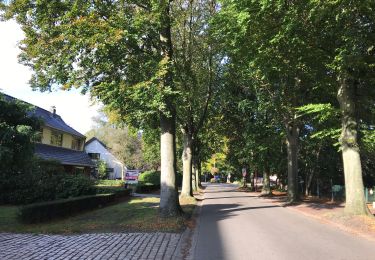
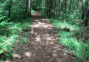
De wildernissen achter de afgebroken watertoren geven verbinding naar de Nederlandse bossen achter Putte om zo door te gaan naar de Klmthoutse Hei via de Grote Meren. Op Belgisch gebied hebben ze verbinding naar het Morethusbos met zijn Ravenhof. Het gebied heeft een mengeling van zand, grond, slijk en leuke singletrails met korte hoogteverschillen en wat ik noem mijn Bike-o-meter ( beetje fysieke gezondheidstest ). Dit is een korte rit maar je kan er kort of lang je hartje ophalen..
Localización
Comentarios
Excursiones cerca
![Excursión A pie Amberes - Wandelpad Eekhoorn - Photo](https://media.geolcdn.com/t/375/260/659c5ebd-94be-43dd-a6ca-7482051fd6ba.jpeg&format=jpg&maxdim=2)
![A pie A pie](https://static1.geolcdn.com/sitytour/trail-icons/100.png)
A pie
![](/images/other/stat-length.png)
![](https://static1.geolcdn.com/siteimages/upload/files/16400158638029165_repeat_loop_refresh_sync_direction_icon.png)
![Excursión A pie Amberes - Wandelpad Specht - Photo](https://media.geolcdn.com/t/375/260/ea3f5fe8-f467-4734-a44c-09edb7f8108d.jpeg&format=jpg&maxdim=2)
![A pie A pie](https://static1.geolcdn.com/sitytour/trail-icons/100.png)
![Excursión Senderismo Woensdrecht - Stoppelbergen Zuidpolder Ossendtecht - Photo](https://media.geolcdn.com/t/375/260/47ffec97-04b0-4eb7-9184-82bea4c120ee.jpg&format=jpg&maxdim=2)
![Senderismo Senderismo](https://static1.geolcdn.com/sitytour/trail-icons/101.png)
Senderismo
![](/images/other/stat-length.png)
![](https://static1.geolcdn.com/siteimages/upload/files/16400158638029165_repeat_loop_refresh_sync_direction_icon.png)
![Excursión Senderismo Stabroek - Kapellen 22 km - Photo](https://media.geolcdn.com/t/375/260/be0a6501-0d47-4ffc-85cc-a71ae92a46ba.jpg&format=jpg&maxdim=2)
![Senderismo Senderismo](https://static1.geolcdn.com/sitytour/trail-icons/101.png)
![Excursión A pie Woensdrecht - Wandelpad Mier - Photo](https://media.geolcdn.com/t/375/260/3a83af8a-158d-4fce-bc2a-0035eb382702.jpeg&format=jpg&maxdim=2)
![A pie A pie](https://static1.geolcdn.com/sitytour/trail-icons/100.png)
A pie
![](/images/other/stat-length.png)
![](https://static1.geolcdn.com/siteimages/upload/files/16400158638029165_repeat_loop_refresh_sync_direction_icon.png)
![Excursión A pie Woensdrecht - Wandelpad Haas - Photo](https://media.geolcdn.com/t/375/260/1ceda016-209b-4e2f-a261-50038dde5e53.jpeg&format=jpg&maxdim=2)
![A pie A pie](https://static1.geolcdn.com/sitytour/trail-icons/100.png)
A pie
![](/images/other/stat-length.png)
![](https://static1.geolcdn.com/siteimages/upload/files/16400158638029165_repeat_loop_refresh_sync_direction_icon.png)
![Excursión Senderismo Woensdrecht - De Kriekelaereduinen - Photo](https://media.geolcdn.com/t/375/260/9490dcd1-0ec3-4949-951e-4e9ff06e4e99.jpg&format=jpg&maxdim=2)
![Senderismo Senderismo](https://static1.geolcdn.com/sitytour/trail-icons/101.png)
Senderismo
![](/images/other/stat-length.png)
![](https://static1.geolcdn.com/siteimages/upload/files/16400158638029165_repeat_loop_refresh_sync_direction_icon.png)
![Excursión Bicicleta Stabroek - f-belgie-rondje-kalmthoutse-heide-brabantse-wal - Photo](https://media.geolcdn.com/t/375/260/ext.jpg?maxdim=2&url=https%3A%2F%2Fstatic1.geolcdn.com%2Fsiteimages%2Fupload%2Ffiles%2F1524743154velo.jpg)
![Bicicleta Bicicleta](https://static1.geolcdn.com/sitytour/trail-icons/200.png)
Bicicleta
![](/images/other/stat-length.png)
![](https://static1.geolcdn.com/siteimages/upload/files/16400158638029165_repeat_loop_refresh_sync_direction_icon.png)
![Excursión Bici de montaña Amberes - m-belgie-zandvliet-01 - Photo](https://media.geolcdn.com/t/375/260/ext.jpg?maxdim=2&url=https%3A%2F%2Fstatic1.geolcdn.com%2Fsiteimages%2Fupload%2Ffiles%2F1524743154velo.jpg)
![Bici de montaña Bici de montaña](https://static1.geolcdn.com/sitytour/trail-icons/202.png)
Bici de montaña
![](/images/other/stat-length.png)
![](https://static1.geolcdn.com/siteimages/upload/files/16400158638029165_repeat_loop_refresh_sync_direction_icon.png)