![](/images/other/stat-length.png)
![Excursión Senderismo Alajeró - Hermitage Garimiar - Imada - Photo](https://media.geolcdn.com/t/1900/400/ext.pjpeg?maxdim=2&url=https%3A%2F%2Fstatic1.geolcdn.com%2Fsiteimages%2Fupload%2Ffiles%2F1553511878bg_sport_marche.png)
Hermitage Garimiar - Imada
mikaou.t
Usuario
![Longitud](/images/other/stat-length.png)
![Altitud máxima](https://static1.geolcdn.com/siteimages/upload/files/1508320355ic_sort_altitude_max_24dp.png)
![Desnivel positivo](https://static1.geolcdn.com/siteimages/upload/files/1508320355ic_sort_den_pos_24dp.png)
![Km-Effort](/images/other/stat-length.png)
![Altitud mínima](https://static1.geolcdn.com/siteimages/upload/files/1508320355ic_sort_altitude_min_24dp.png)
![Desnivel negativo](https://static1.geolcdn.com/siteimages/upload/files/1508320355ic_sort_den_neg_24dp.png)
![Boucle](https://static1.geolcdn.com/siteimages/upload/files/16400158638029165_repeat_loop_refresh_sync_direction_icon.png)
![Senderismo](https://static1.geolcdn.com/sitytour/trail-icons/101.png)
4h12
Dificultad : Difícil
![Escanee este código QR para abrir la excursión en la aplicación SityTrail](https://capi.geolives.com/qq0zvz2zws4bq2lad0pu/sitytour/trails/2039705/qr.png?size=200)
Aplicación GPS de excursión GRATIS
A propósito
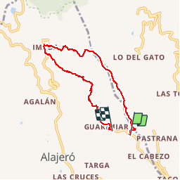
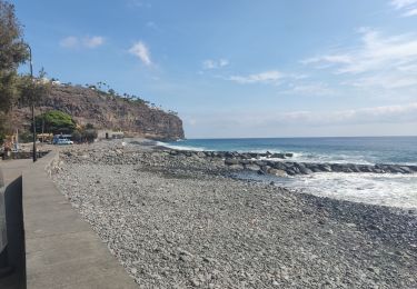
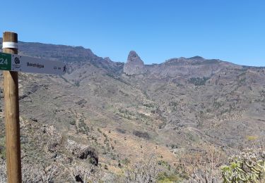
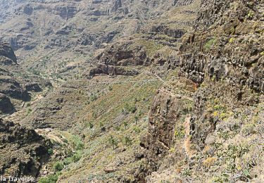
Ruta Senderismo de 8,3 km a descubrir en Canarias, Santa Cruz de Tenerife, Alajeró. Esta ruta ha sido propuesta por mikaou.t.
Descripción
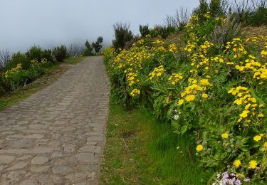
superbe circuit. L'Hermitage, petite chapelle à gauche de la route. Se garer, début du sentier face à la chapelle pente en ciment. Peu avant la maison prendre la piste à droite et suivre le tracé GPS.
A Imada, bar où on peut manger aavant de faire la descente inoubliable.
Localización
Comentarios
Excursiones cerca
![Excursión Senderismo San Sebastián de la Gomera - La Gomera - La Zarcita la Laja el Bailadero 7/5/2019 - Photo](https://media.geolcdn.com/t/375/260/f8d4614d-4c66-4ecc-89c4-7f24d5cd179e.jpg&format=jpg&maxdim=2)
![Senderismo Senderismo](https://static1.geolcdn.com/sitytour/trail-icons/101.png)
Senderismo
![](/images/other/stat-length.png)
![](https://static1.geolcdn.com/siteimages/upload/files/16400158638029165_repeat_loop_refresh_sync_direction_icon.png)
![Excursión A pie Alajeró - Ruta 16: Pajarito - Ajugal - Photo](https://media.geolcdn.com/t/375/260/de173e01-927b-4cca-bc9d-79cda4d5f77d.jpeg&format=jpg&maxdim=2)
![A pie A pie](https://static1.geolcdn.com/sitytour/trail-icons/100.png)
A pie
![](/images/other/stat-length.png)
![](https://static1.geolcdn.com/siteimages/upload/files/16400158638029165_repeat_loop_refresh_sync_direction_icon.png)
![Excursión A pie Hermigua - Ruta 17: Pajarito - Alto de Garajonay - Pajarito - Photo](https://media.geolcdn.com/t/375/260/72d2f045-c0bf-444b-8c36-7a4692fcc430.jpeg&format=jpg&maxdim=2)
![A pie A pie](https://static1.geolcdn.com/sitytour/trail-icons/100.png)
A pie
![](/images/other/stat-length.png)
![](https://static1.geolcdn.com/siteimages/upload/files/16400158638029165_repeat_loop_refresh_sync_direction_icon.png)
![Excursión Senderismo Alajeró - Alajero - Playa Santiago - Photo](https://media.geolcdn.com/t/375/260/e548ab48-5d01-4337-8f8d-853edb98d646.jpg&format=jpg&maxdim=2)
![Senderismo Senderismo](https://static1.geolcdn.com/sitytour/trail-icons/101.png)
Senderismo
![](/images/other/stat-length.png)
![](https://static1.geolcdn.com/siteimages/upload/files/16400158638029165_repeat_loop_refresh_sync_direction_icon.png)
![Excursión Senderismo Alajeró - Pajarito - Hermigua (Ibo Alfaro) - Photo](https://media.geolcdn.com/t/375/260/4a2c30b9-a73d-45cf-9210-6dbca82d3e7a.jpg&format=jpg&maxdim=2)
![Senderismo Senderismo](https://static1.geolcdn.com/sitytour/trail-icons/101.png)
Senderismo
![](/images/other/stat-length.png)
![](https://static1.geolcdn.com/siteimages/upload/files/16400158638029165_repeat_loop_refresh_sync_direction_icon.png)
![Excursión Senderismo Alajeró - Evening walk around Alojero - Photo](https://media.geolcdn.com/t/375/260/d8bd04d2-9002-4339-bccc-7795e2a65558.jpg&format=jpg&maxdim=2)
![Senderismo Senderismo](https://static1.geolcdn.com/sitytour/trail-icons/101.png)
Senderismo
![](/images/other/stat-length.png)
![](https://static1.geolcdn.com/siteimages/upload/files/16400158638029165_repeat_loop_refresh_sync_direction_icon.png)
![Excursión Senderismo Alajeró - Canaries - La Gomera - Imada - Jour 5 - Photo](https://media.geolcdn.com/t/375/260/77e4c589-e7e6-44c2-8f73-fe61ca14e614.jpg&format=jpg&maxdim=2)
![Senderismo Senderismo](https://static1.geolcdn.com/sitytour/trail-icons/101.png)
Senderismo
![](/images/other/stat-length.png)
![](https://static1.geolcdn.com/siteimages/upload/files/16400158638029165_repeat_loop_refresh_sync_direction_icon.png)
![Excursión Senderismo Alajeró - La Gomera - Hermita de Guarimiar à Imada 3/5/2019 - Photo](https://media.geolcdn.com/t/375/260/ext.jpg?maxdim=2&url=https%3A%2F%2Fstatic1.geolcdn.com%2Fsiteimages%2Fupload%2Ffiles%2F1553511878bg_sport_marche.png)
![Senderismo Senderismo](https://static1.geolcdn.com/sitytour/trail-icons/101.png)
Senderismo
![](/images/other/stat-length.png)
![](https://static1.geolcdn.com/siteimages/upload/files/16400158638029165_repeat_loop_refresh_sync_direction_icon.png)
![Excursión Senderismo Alajeró - Village d'Imada Saint Sébastien de La Gomera - Photo](https://media.geolcdn.com/t/375/260/a83f86b4-9ae7-4819-8f3e-c7685f864537.jpg&format=jpg&maxdim=2)
![Senderismo Senderismo](https://static1.geolcdn.com/sitytour/trail-icons/101.png)
Senderismo
![](/images/other/stat-length.png)
![](https://static1.geolcdn.com/siteimages/upload/files/16400158638029165_repeat_loop_refresh_sync_direction_icon.png)
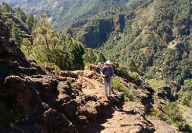
joli sentier panoramique en corniche. Au départ le chemin derrière la maison depuis l'escalier après la pente en béton n'est pas facile à repérer.