![](/images/other/stat-length.png)
![Excursión Senderismo Pétange - Mijnwerkerpad / Sentier Des Mineurs - Photo](https://media.geolcdn.com/t/1900/400/ext.pjpeg?maxdim=2&url=https%3A%2F%2Fstatic1.geolcdn.com%2Fsiteimages%2Fupload%2Ffiles%2F1553511878bg_sport_marche.png)
Mijnwerkerpad / Sentier Des Mineurs
flip96
Usuario
![Longitud](/images/other/stat-length.png)
Longitud
29 km
![Altitud máxima](https://static1.geolcdn.com/siteimages/upload/files/1508320355ic_sort_altitude_max_24dp.png)
Altitud máxima
433 m
![Desnivel positivo](https://static1.geolcdn.com/siteimages/upload/files/1508320355ic_sort_den_pos_24dp.png)
Desnivel positivo
665 m
![Km-Effort](/images/other/stat-length.png)
Km-Effort
38 km
![Altitud mínima](https://static1.geolcdn.com/siteimages/upload/files/1508320355ic_sort_altitude_min_24dp.png)
Altitud mínima
289 m
![Desnivel negativo](https://static1.geolcdn.com/siteimages/upload/files/1508320355ic_sort_den_neg_24dp.png)
Desnivel negativo
666 m
![Boucle](https://static1.geolcdn.com/siteimages/upload/files/16400158638029165_repeat_loop_refresh_sync_direction_icon.png)
Boucle
Sí
Fecha de creación :
2014-12-10 00:00:00.0
Última modificación :
2014-12-10 00:00:00.0
![Senderismo](https://static1.geolcdn.com/sitytour/trail-icons/101.png)
8h01
Dificultad : Medio
![Escanee este código QR para abrir la excursión en la aplicación SityTrail](https://capi.geolives.com/qq0zvz2zws4bq2lad0pu/sitytour/trails/203432/qr.png?size=200)
Aplicación GPS de excursión GRATIS
A propósito
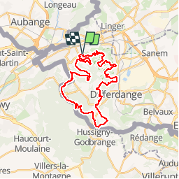
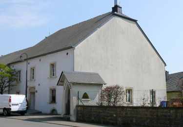
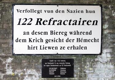
Ruta Senderismo de 29 km a descubrir en Desconocido, Canton Esch-sur-Alzette, Pétange. Esta ruta ha sido propuesta por flip96.
Descripción
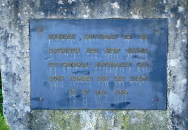
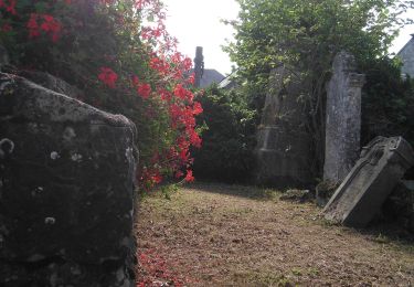
Sentier des Mineurs vanuit Lamadelaine. Pad is aangegeven met gele bol. Markering is plaatselijk erg onduidelijk!!!
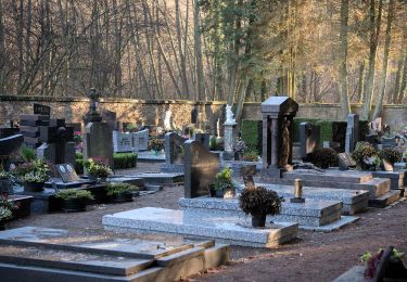
Mooie route, maar heb zelf ca. 35km. gelopen i.v.m. vele bezienswaardigheden onderweg.
Opmerkingen? flip96@home.nl
Localización
País:
Luxembourg
Región :
Desconocido
Departamento/provincia :
Canton Esch-sur-Alzette
Municipio :
Pétange
Localidad:
Unknown
Salida:(Dec)
Salida:(UTM)
706578 ; 5492137 (31U) N.
Comentarios
Excursiones cerca
![Excursión A pie Aubange - BE-AU 01 - Photo](https://media.geolcdn.com/t/375/260/7f7289b5-d5ab-4003-b78e-f5dd73f8883f.jpeg&format=jpg&maxdim=2)
![A pie A pie](https://static1.geolcdn.com/sitytour/trail-icons/100.png)
![Excursión A pie Pétange - Auto-Pédestre Pétange - Photo](https://media.geolcdn.com/t/375/260/3bda8901-8a45-455f-a0d9-28619ac75e15.jpeg&format=jpg&maxdim=2)
![A pie A pie](https://static1.geolcdn.com/sitytour/trail-icons/100.png)
Auto-Pédestre Pétange
A pie
Fácil
Pétange,
Desconocido,
Canton Esch-sur-Alzette,
Luxembourg
![](/images/other/stat-length.png)
8,3 km | 10,4 km-effort
2h 21min
![](https://static1.geolcdn.com/siteimages/upload/files/16400158638029165_repeat_loop_refresh_sync_direction_icon.png)
Sí
![Excursión A pie Pétange - Auto-Pédestre Lamadelaine - Photo](https://media.geolcdn.com/t/375/260/b8abde83-d7ee-4d08-8b56-7c6d44fc17fc.jpeg&format=jpg&maxdim=2)
![A pie A pie](https://static1.geolcdn.com/sitytour/trail-icons/100.png)
Auto-Pédestre Lamadelaine
A pie
Fácil
Pétange,
Desconocido,
Canton Esch-sur-Alzette,
Luxembourg
![](/images/other/stat-length.png)
10,8 km | 13,4 km-effort
3h 2min
![](https://static1.geolcdn.com/siteimages/upload/files/16400158638029165_repeat_loop_refresh_sync_direction_icon.png)
Sí
![Excursión A pie Käerjeng - Sentier Naturfrenn Käerjéng - Photo](https://media.geolcdn.com/t/375/260/60dcdf91-6252-4ac8-b795-309bfee6f33c.jpeg&format=jpg&maxdim=2)
![A pie A pie](https://static1.geolcdn.com/sitytour/trail-icons/100.png)
Sentier Naturfrenn Käerjéng
A pie
Fácil
Käerjeng,
Desconocido,
Canton Capellen,
Luxembourg
![](/images/other/stat-length.png)
8,5 km | 10,4 km-effort
2h 22min
![](https://static1.geolcdn.com/siteimages/upload/files/16400158638029165_repeat_loop_refresh_sync_direction_icon.png)
Sí
![Excursión A pie Käerjeng - Auto-Pédestre Bascharage - Photo](https://media.geolcdn.com/t/375/260/f1279973-8e1f-4680-90f5-548cd507bf83.jpeg&format=jpg&maxdim=2)
![A pie A pie](https://static1.geolcdn.com/sitytour/trail-icons/100.png)
Auto-Pédestre Bascharage
A pie
Fácil
Käerjeng,
Desconocido,
Canton Capellen,
Luxembourg
![](/images/other/stat-length.png)
9 km | 10,6 km-effort
2h 24min
![](https://static1.geolcdn.com/siteimages/upload/files/16400158638029165_repeat_loop_refresh_sync_direction_icon.png)
Sí
![Excursión A pie Aubange - Le Joli Bois - Photo](https://media.geolcdn.com/t/375/260/004d9deb-44d3-48df-b1f8-dbcc850899c2.jpeg&format=jpg&maxdim=2)
![A pie A pie](https://static1.geolcdn.com/sitytour/trail-icons/100.png)
![Excursión A pie Haucourt-Moulaine - Sentier du Beau Chêne - Photo](https://media.geolcdn.com/t/375/260/f060c4d5-b3a7-4872-84e5-b1f11835f082.jpeg&format=jpg&maxdim=2)
![A pie A pie](https://static1.geolcdn.com/sitytour/trail-icons/100.png)
Sentier du Beau Chêne
A pie
Fácil
Haucourt-Moulaine,
Gran Este,
Meurthe y Mosela,
France
![](/images/other/stat-length.png)
10,8 km | 13,7 km-effort
3h 6min
![](https://static1.geolcdn.com/siteimages/upload/files/16400158638029165_repeat_loop_refresh_sync_direction_icon.png)
Sí
![Excursión A pie Differdange - Sentier du Temps Perdu - Photo](https://media.geolcdn.com/t/375/260/f2ec4c4a-e3b0-42a8-a4b9-f770a42da903.jpeg&format=jpg&maxdim=2)
![A pie A pie](https://static1.geolcdn.com/sitytour/trail-icons/100.png)
Sentier du Temps Perdu
A pie
Fácil
Differdange,
Desconocido,
Canton Esch-sur-Alzette,
Luxembourg
![](/images/other/stat-length.png)
6,6 km | 9,1 km-effort
2h 4min
![](https://static1.geolcdn.com/siteimages/upload/files/16400158638029165_repeat_loop_refresh_sync_direction_icon.png)
Sí
![Excursión A pie Käerjeng - Auto-Pédestre Clemency 2 - Photo](https://media.geolcdn.com/t/375/260/6e6d7a4f-b83f-4d40-a520-6650674faa3f.jpeg&format=jpg&maxdim=2)
![A pie A pie](https://static1.geolcdn.com/sitytour/trail-icons/100.png)
Auto-Pédestre Clemency 2
A pie
Fácil
Käerjeng,
Desconocido,
Canton Capellen,
Luxembourg
![](/images/other/stat-length.png)
8,4 km | 10 km-effort
2h 16min
![](https://static1.geolcdn.com/siteimages/upload/files/16400158638029165_repeat_loop_refresh_sync_direction_icon.png)
Sí