![](/images/other/stat-length.png)
![Excursión A pie Mérignac - LE BURCK MOULIN DE NOES PIQUE CAILLOU LUCHEY HALDE - Photo](https://media.geolcdn.com/t/1900/400/ext.pjpeg?maxdim=2&url=https%3A%2F%2Fstatic1.geolcdn.com%2Fsiteimages%2Fupload%2Ffiles%2F1545311037marcheuse_200dpi.jpg)
LE BURCK MOULIN DE NOES PIQUE CAILLOU LUCHEY HALDE
papyrandonneur
Usuario
![Longitud](/images/other/stat-length.png)
![Altitud máxima](https://static1.geolcdn.com/siteimages/upload/files/1508320355ic_sort_altitude_max_24dp.png)
![Desnivel positivo](https://static1.geolcdn.com/siteimages/upload/files/1508320355ic_sort_den_pos_24dp.png)
![Km-Effort](/images/other/stat-length.png)
![Altitud mínima](https://static1.geolcdn.com/siteimages/upload/files/1508320355ic_sort_altitude_min_24dp.png)
![Desnivel negativo](https://static1.geolcdn.com/siteimages/upload/files/1508320355ic_sort_den_neg_24dp.png)
![Boucle](https://static1.geolcdn.com/siteimages/upload/files/16400158638029165_repeat_loop_refresh_sync_direction_icon.png)
![A pie](https://static1.geolcdn.com/sitytour/trail-icons/100.png)
--
Dificultad : Muy fácil
![Escanee este código QR para abrir la excursión en la aplicación SityTrail](https://capi.geolives.com/qq0zvz2zws4bq2lad0pu/sitytour/trails/2031395/qr.png?size=200)
Aplicación GPS de excursión GRATIS
A propósito
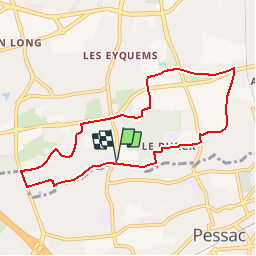
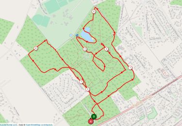
Ruta A pie de 8,4 km a descubrir en Nueva Aquitania, Gironda, Mérignac. Esta ruta ha sido propuesta por papyrandonneur.
Descripción
départ du stade Cruchon tout autour du Burck vers Moulin de Noes puis Garies un morceau de V D O retour au bois du Burck on longe Pique Caillou on contourne Luchey Halde on passe devant le château du Burck et on revient su r le bois du Burck et le stade
Localización
Comentarios
Excursiones cerca
![Excursión Senderismo Pessac - bourghail - Photo](https://media.geolcdn.com/t/375/260/54a8f206-54b2-441d-8f94-6216cdd347dd.jpg&format=jpg&maxdim=2)
![Senderismo Senderismo](https://static1.geolcdn.com/sitytour/trail-icons/101.png)
Senderismo
![](/images/other/stat-length.png)
![](https://static1.geolcdn.com/siteimages/upload/files/16400158638029165_repeat_loop_refresh_sync_direction_icon.png)
![Excursión Marcha nórdica Pessac - Le Bourgailh 2024-10-20 reco - Photo](https://media.geolcdn.com/t/375/260/fd0705c7-40d4-42d6-8e85-ce97a605d44b.jpg&format=jpg&maxdim=2)
![Marcha nórdica Marcha nórdica](https://static1.geolcdn.com/sitytour/trail-icons/102.png)
Marcha nórdica
![](/images/other/stat-length.png)
![](https://static1.geolcdn.com/siteimages/upload/files/16400158638029165_repeat_loop_refresh_sync_direction_icon.png)
![Excursión Senderismo Pessac - bourghail - Photo](https://media.geolcdn.com/t/375/260/9aabf021-ec90-4536-8cac-314678e58a33.jpg&format=jpg&maxdim=2)
![Senderismo Senderismo](https://static1.geolcdn.com/sitytour/trail-icons/101.png)
Senderismo
![](/images/other/stat-length.png)
![](https://static1.geolcdn.com/siteimages/upload/files/16400158638029165_repeat_loop_refresh_sync_direction_icon.png)
![Excursión Senderismo Mérignac - Mérignac les parcs - Photo](https://media.geolcdn.com/t/375/260/8660a1b9-6ee7-4218-8580-06d07d66b132.jpg&format=jpg&maxdim=2)
![Senderismo Senderismo](https://static1.geolcdn.com/sitytour/trail-icons/101.png)
Senderismo
![](/images/other/stat-length.png)
![](https://static1.geolcdn.com/siteimages/upload/files/16400158638029165_repeat_loop_refresh_sync_direction_icon.png)
![Excursión Senderismo Mérignac - Pape Clément - Photo](https://media.geolcdn.com/t/375/260/fce6217a-5537-4b49-813e-e5d17480eae3.jpg&format=jpg&maxdim=2)
![Senderismo Senderismo](https://static1.geolcdn.com/sitytour/trail-icons/101.png)
Senderismo
![](/images/other/stat-length.png)
![](https://static1.geolcdn.com/siteimages/upload/files/16400158638029165_repeat_loop_refresh_sync_direction_icon.png)
![Excursión Marcha nórdica Pessac - Le bois de la princesse 25 avr. 2018 - Photo](https://media.geolcdn.com/t/375/260/20cc35c2-e185-4757-b72b-9a33d79f4c2c.jpg&format=jpg&maxdim=2)
![Marcha nórdica Marcha nórdica](https://static1.geolcdn.com/sitytour/trail-icons/102.png)
Marcha nórdica
![](/images/other/stat-length.png)
![](https://static1.geolcdn.com/siteimages/upload/files/16400158638029165_repeat_loop_refresh_sync_direction_icon.png)
![Senderismo Senderismo](https://static1.geolcdn.com/sitytour/trail-icons/101.png)
Senderismo
![](/images/other/stat-length.png)
![](https://static1.geolcdn.com/siteimages/upload/files/16400158638029165_repeat_loop_refresh_sync_direction_icon.png)
![Excursión Senderismo Pessac - Pessac - Photo](https://media.geolcdn.com/t/375/260/e062a715-6f64-40f4-8896-dca8d520e118.jpg&format=jpg&maxdim=2)
![Senderismo Senderismo](https://static1.geolcdn.com/sitytour/trail-icons/101.png)
![Excursión Senderismo Gradignan - Tannerie - Photo](https://media.geolcdn.com/t/375/260/bb5bc2d6-014b-49c1-a6ee-5acdc2b80c24.jpg&format=jpg&maxdim=2)
![Senderismo Senderismo](https://static1.geolcdn.com/sitytour/trail-icons/101.png)
Senderismo
![](/images/other/stat-length.png)
![](https://static1.geolcdn.com/siteimages/upload/files/16400158638029165_repeat_loop_refresh_sync_direction_icon.png)