![](/images/other/stat-length.png)
![Excursión Senderismo Baiersbronn - Ruhestein Wildsee Darmstädter Hütte - Photo](https://media.geolcdn.com/t/1900/400/ext.pjpeg?maxdim=2&url=https%3A%2F%2Fstatic1.geolcdn.com%2Fsiteimages%2Fupload%2Ffiles%2F1553511878bg_sport_marche.png)
Ruhestein Wildsee Darmstädter Hütte
pjjrevrard
Usuario
![Longitud](/images/other/stat-length.png)
![Altitud máxima](https://static1.geolcdn.com/siteimages/upload/files/1508320355ic_sort_altitude_max_24dp.png)
![Desnivel positivo](https://static1.geolcdn.com/siteimages/upload/files/1508320355ic_sort_den_pos_24dp.png)
![Km-Effort](/images/other/stat-length.png)
![Altitud mínima](https://static1.geolcdn.com/siteimages/upload/files/1508320355ic_sort_altitude_min_24dp.png)
![Desnivel negativo](https://static1.geolcdn.com/siteimages/upload/files/1508320355ic_sort_den_neg_24dp.png)
![Boucle](https://static1.geolcdn.com/siteimages/upload/files/16400158638029165_repeat_loop_refresh_sync_direction_icon.png)
![Senderismo](https://static1.geolcdn.com/sitytour/trail-icons/101.png)
3h03
Dificultad : Difícil
![Escanee este código QR para abrir la excursión en la aplicación SityTrail](https://capi.geolives.com/qq0zvz2zws4bq2lad0pu/sitytour/trails/202638/qr.png?size=200)
Aplicación GPS de excursión GRATIS
A propósito
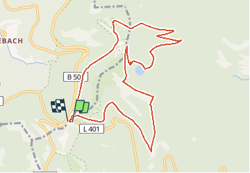
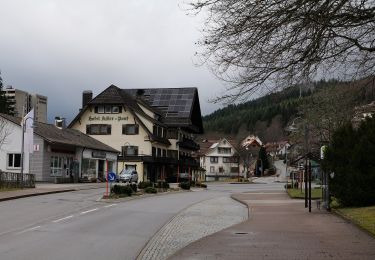
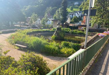
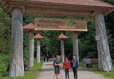
Ruta Senderismo de 10,6 km a descubrir en Baden-Wurtemberg, Landkreis Freudenstadt, Baiersbronn. Esta ruta ha sido propuesta por pjjrevrard.
Descripción
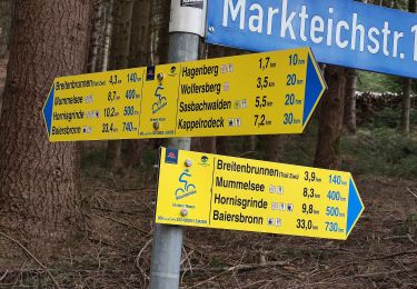
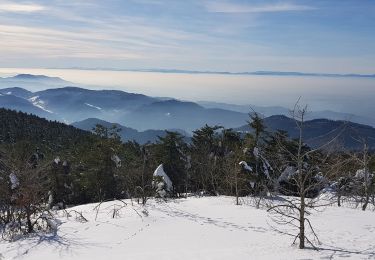
Variante courte de la rando vers le Wildsee (petit lac glaciaire). Le tronçon entre les points A et B est peu fréquenté et peu visible. Le tronçon entre C et D est dangereux (sentier à forte pente et passages dangereux). La variante proposée sur ce site est plus longue mais beaucoup plus confortable.
Localización
Comentarios
Excursiones cerca
![Excursión A pie Sasbachwalden - Hinterer Wasen - Breitenbrunnen - bequemer Weg - Photo](https://media.geolcdn.com/t/375/260/2a70dab6-d16d-496c-83ef-4ce249797e66.jpeg&format=jpg&maxdim=2)
![A pie A pie](https://static1.geolcdn.com/sitytour/trail-icons/100.png)
A pie
![](/images/other/stat-length.png)
![](https://static1.geolcdn.com/siteimages/upload/files/16400158638029165_repeat_loop_refresh_sync_direction_icon.png)
![Excursión A pie Seebach - Genießerpfad - Bosensteiner Almpfad - Photo](https://media.geolcdn.com/t/375/260/11bc9928-9038-4c09-9def-e2a7cd4d3a52.jpeg&format=jpg&maxdim=2)
![A pie A pie](https://static1.geolcdn.com/sitytour/trail-icons/100.png)
A pie
![](/images/other/stat-length.png)
![](https://static1.geolcdn.com/siteimages/upload/files/16400158638029165_repeat_loop_refresh_sync_direction_icon.png)
![Excursión A pie Seebach - Genießerpfad - Mummelsee-Hornisgrindepfad - Photo](https://media.geolcdn.com/t/375/260/b7f55c4c-3b6e-43c3-b3b8-3d4fe2e91a2e.jpeg&format=jpg&maxdim=2)
![A pie A pie](https://static1.geolcdn.com/sitytour/trail-icons/100.png)
A pie
![](/images/other/stat-length.png)
![](https://static1.geolcdn.com/siteimages/upload/files/16400158638029165_repeat_loop_refresh_sync_direction_icon.png)
![Excursión A pie Baiersbronn - Schöner Platz-Hänger - Photo](https://media.geolcdn.com/t/375/260/5b10d9e5-2618-4744-9ada-f0ae0a8d407b.jpeg&format=jpg&maxdim=2)
![A pie A pie](https://static1.geolcdn.com/sitytour/trail-icons/100.png)
A pie
![](/images/other/stat-length.png)
![](https://static1.geolcdn.com/siteimages/upload/files/16400158638029165_repeat_loop_refresh_sync_direction_icon.png)
![Excursión A pie Baiersbronn - Obertal - Ruhestein - Photo](https://media.geolcdn.com/t/375/260/09073c85-2cf4-4125-861f-681bd4185571.jpeg&format=jpg&maxdim=2)
![A pie A pie](https://static1.geolcdn.com/sitytour/trail-icons/100.png)
A pie
![](/images/other/stat-length.png)
![](https://static1.geolcdn.com/siteimages/upload/files/16400158638029165_repeat_loop_refresh_sync_direction_icon.png)
![Excursión A pie Baiersbronn - Obertal - Zuflucht - Photo](https://media.geolcdn.com/t/375/260/09073c85-2cf4-4125-861f-681bd4185571.jpeg&format=jpg&maxdim=2)
![A pie A pie](https://static1.geolcdn.com/sitytour/trail-icons/100.png)
A pie
![](/images/other/stat-length.png)
![](https://static1.geolcdn.com/siteimages/upload/files/16400158638029165_repeat_loop_refresh_sync_direction_icon.png)
![Excursión Senderismo Ottenhöfen im Schwarzwald - Karlsruher Gray - Photo](https://media.geolcdn.com/t/375/260/306921ae-0cb6-4706-b01c-4fa713274eb6.jpg&format=jpg&maxdim=2)
![Senderismo Senderismo](https://static1.geolcdn.com/sitytour/trail-icons/101.png)
Senderismo
![](/images/other/stat-length.png)
![](https://static1.geolcdn.com/siteimages/upload/files/16400158638029165_repeat_loop_refresh_sync_direction_icon.png)
![Excursión Senderismo Oppenau - allerheiligen - Photo](https://media.geolcdn.com/t/375/260/4aa53ab8-200a-4e58-8b67-302ac8d8b6a5.jpg&format=jpg&maxdim=2)
![Senderismo Senderismo](https://static1.geolcdn.com/sitytour/trail-icons/101.png)
Senderismo
![](/images/other/stat-length.png)
![](https://static1.geolcdn.com/siteimages/upload/files/16400158638029165_repeat_loop_refresh_sync_direction_icon.png)
![Excursión Senderismo Seebach - mummelsee - grindehutte - Photo](https://media.geolcdn.com/t/375/260/47f853e6-b90a-402f-9686-564c035d718c.jpg&format=jpg&maxdim=2)
![Senderismo Senderismo](https://static1.geolcdn.com/sitytour/trail-icons/101.png)
Senderismo
![](/images/other/stat-length.png)
![](https://static1.geolcdn.com/siteimages/upload/files/16400158638029165_repeat_loop_refresh_sync_direction_icon.png)