![](/images/other/stat-length.png)
![Excursión Otra actividad Sisikon - Sisikon - Brunnen - Photo](https://media.geolcdn.com/t/1900/400/ext.pjpeg?maxdim=2&url=https%3A%2F%2Fstatic1.geolcdn.com%2Fsiteimages%2Fupload%2Ffiles%2F1545311037marcheuse_200dpi.jpg)
Sisikon - Brunnen
jschna
Usuario
![Longitud](/images/other/stat-length.png)
![Altitud máxima](https://static1.geolcdn.com/siteimages/upload/files/1508320355ic_sort_altitude_max_24dp.png)
![Desnivel positivo](https://static1.geolcdn.com/siteimages/upload/files/1508320355ic_sort_den_pos_24dp.png)
![Km-Effort](/images/other/stat-length.png)
![Altitud mínima](https://static1.geolcdn.com/siteimages/upload/files/1508320355ic_sort_altitude_min_24dp.png)
![Desnivel negativo](https://static1.geolcdn.com/siteimages/upload/files/1508320355ic_sort_den_neg_24dp.png)
![Boucle](https://static1.geolcdn.com/siteimages/upload/files/16400158638029165_repeat_loop_refresh_sync_direction_icon.png)
![Otra actividad](https://static1.geolcdn.com/sitytour/trail-icons/900.png)
--
Dificultad : Desconocido
![Escanee este código QR para abrir la excursión en la aplicación SityTrail](https://capi.geolives.com/qq0zvz2zws4bq2lad0pu/sitytour/trails/20258/qr.png?size=200)
Aplicación GPS de excursión GRATIS
A propósito
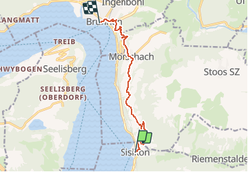
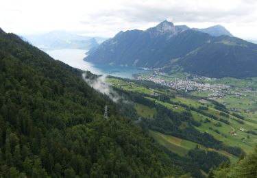
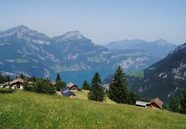
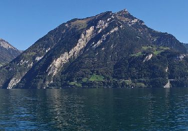
Ruta Otra actividad de 10,3 km a descubrir en Uri, Desconocido, Sisikon. Esta ruta ha sido propuesta por jschna.
Descripción
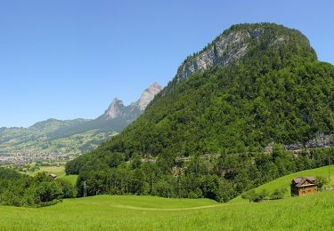
Vom Bahnhof Sisikon steigt der Weg für ca. 45 Min. ziemlich steil an, dann gehts etwas gemächlicher. Stets eine wunderschöne Aussicht vor Augen, muss man von Zeit zu Zeit Pause machen und diese Rundsicht geniessen. Verpflegen kann man sich in Morschach, oder aber in Brunnen, wo das Angebot noch grösser ist. (In der Marschzeit sind auch ca. 40 Min. Pausen inbegriffen.)
Localización
Comentarios
Excursiones cerca
![Excursión A pie Morschach - Stoos - Klingenstock - Photo](https://media.geolcdn.com/t/375/260/7f4d7922-1b45-4336-bb8c-cff5bc34903a.jpeg&format=jpg&maxdim=2)
![A pie A pie](https://static1.geolcdn.com/sitytour/trail-icons/100.png)
A pie
![](/images/other/stat-length.png)
![](https://static1.geolcdn.com/siteimages/upload/files/16400158638029165_repeat_loop_refresh_sync_direction_icon.png)
![Excursión A pie Morschach - Morschach - Stoss - Photo](https://media.geolcdn.com/t/375/260/173b4dbb-56ad-42ac-9fee-76e2b9dfa97c.jpeg&format=jpg&maxdim=2)
![A pie A pie](https://static1.geolcdn.com/sitytour/trail-icons/100.png)
A pie
![](/images/other/stat-length.png)
![](https://static1.geolcdn.com/siteimages/upload/files/16400158638029165_repeat_loop_refresh_sync_direction_icon.png)
![Excursión A pie Schwyz - Schlattli - Bläckerli - Photo](https://media.geolcdn.com/t/375/260/0643cf6c-7e1e-4917-b43f-d254d826e1b9.jpeg&format=jpg&maxdim=2)
![A pie A pie](https://static1.geolcdn.com/sitytour/trail-icons/100.png)
A pie
![](/images/other/stat-length.png)
![](https://static1.geolcdn.com/siteimages/upload/files/16400158638029165_repeat_loop_refresh_sync_direction_icon.png)
![Excursión A pie Morschach - Furgeli - Chlingenstock - Photo](https://media.geolcdn.com/t/375/260/7158b266-84ca-491f-b823-c61d69de5f50.jpeg&format=jpg&maxdim=2)
![A pie A pie](https://static1.geolcdn.com/sitytour/trail-icons/100.png)
A pie
![](/images/other/stat-length.png)
![](https://static1.geolcdn.com/siteimages/upload/files/16400158638029165_repeat_loop_refresh_sync_direction_icon.png)
![Excursión A pie Morschach - Stoos - Fronalpstock - Photo](https://media.geolcdn.com/t/375/260/d93f804b-3378-41f2-a689-d558ba93fd11.jpeg&format=jpg&maxdim=2)
![A pie A pie](https://static1.geolcdn.com/sitytour/trail-icons/100.png)
A pie
![](/images/other/stat-length.png)
![](https://static1.geolcdn.com/siteimages/upload/files/16400158638029165_repeat_loop_refresh_sync_direction_icon.png)
![Excursión A pie Morschach - Schwyzerhöchi - Stoos - Photo](https://media.geolcdn.com/t/375/260/d93f804b-3378-41f2-a689-d558ba93fd11.jpeg&format=jpg&maxdim=2)
![A pie A pie](https://static1.geolcdn.com/sitytour/trail-icons/100.png)
A pie
![](/images/other/stat-length.png)
![](https://static1.geolcdn.com/siteimages/upload/files/16400158638029165_repeat_loop_refresh_sync_direction_icon.png)
![Excursión A pie Flüelen - Wildheupfad - Photo](https://media.geolcdn.com/t/375/260/33bc141d-4e96-4498-b249-f0289ac01b32.jpeg&format=jpg&maxdim=2)
![A pie A pie](https://static1.geolcdn.com/sitytour/trail-icons/100.png)
![Excursión A pie Seedorf (UR) - Bauen-Schloss Beroldingen - Photo](https://media.geolcdn.com/t/375/260/96bcd15d-b3da-477d-bf24-53be113f3dfb.jpeg&format=jpg&maxdim=2)
![A pie A pie](https://static1.geolcdn.com/sitytour/trail-icons/100.png)
A pie
![](/images/other/stat-length.png)
![](https://static1.geolcdn.com/siteimages/upload/files/16400158638029165_repeat_loop_refresh_sync_direction_icon.png)
![Excursión Otra actividad Isenthal - y10_Isenthal - Photo](https://media.geolcdn.com/t/375/260/ext.jpg?maxdim=2&url=https%3A%2F%2Fstatic1.geolcdn.com%2Fsiteimages%2Fupload%2Ffiles%2F1545311037marcheuse_200dpi.jpg)
![Otra actividad Otra actividad](https://static1.geolcdn.com/sitytour/trail-icons/900.png)
Otra actividad
![](/images/other/stat-length.png)
![](https://static1.geolcdn.com/siteimages/upload/files/16400158638029165_repeat_loop_refresh_sync_direction_icon.png)