![](/images/other/stat-length.png)
![Excursión Senderismo Leimbach - Leimbach - Chalet Zuber - Photo](https://media.geolcdn.com/t/1900/400/ext.pjpeg?maxdim=2&url=https%3A%2F%2Fstatic1.geolcdn.com%2Fsiteimages%2Fupload%2Ffiles%2F1553511878bg_sport_marche.png)
Leimbach - Chalet Zuber
patrickbeyrath
Usuario
![Longitud](/images/other/stat-length.png)
Longitud
8,5 km
![Altitud máxima](https://static1.geolcdn.com/siteimages/upload/files/1508320355ic_sort_altitude_max_24dp.png)
Altitud máxima
647 m
![Desnivel positivo](https://static1.geolcdn.com/siteimages/upload/files/1508320355ic_sort_den_pos_24dp.png)
Desnivel positivo
341 m
![Km-Effort](/images/other/stat-length.png)
Km-Effort
13 km
![Altitud mínima](https://static1.geolcdn.com/siteimages/upload/files/1508320355ic_sort_altitude_min_24dp.png)
Altitud mínima
357 m
![Desnivel negativo](https://static1.geolcdn.com/siteimages/upload/files/1508320355ic_sort_den_neg_24dp.png)
Desnivel negativo
337 m
![Boucle](https://static1.geolcdn.com/siteimages/upload/files/16400158638029165_repeat_loop_refresh_sync_direction_icon.png)
Boucle
Sí
Fecha de creación :
2018-12-07 08:21:02.977
Última modificación :
2018-12-07 08:27:56.896
![Senderismo](https://static1.geolcdn.com/sitytour/trail-icons/101.png)
2h42
Dificultad : Medio
![Escanee este código QR para abrir la excursión en la aplicación SityTrail](https://capi.geolives.com/qq0zvz2zws4bq2lad0pu/sitytour/trails/2018896/qr.png?size=200)
Aplicación GPS de excursión GRATIS
A propósito
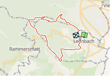
Ruta Senderismo de 8,5 km a descubrir en Gran Este, Alto Rin, Leimbach. Esta ruta ha sido propuesta por patrickbeyrath.
Descripción
Parking mairie Leimbach - Les Trois Chênes ) Tempel - Muhlberg - Col du Teufelsgrund - Chalet Zuber - descente rond rouge puis prendre à gauche Riegelsbourg et retour parking
Localización
País:
France
Región :
Gran Este
Departamento/provincia :
Alto Rin
Municipio :
Leimbach
Localidad:
Unknown
Salida:(Dec)
Salida:(UTM)
357786 ; 5295059 (32T) N.
Comentarios
Excursiones cerca
![Excursión Senderismo Sentheim - Sentheim Rossberg - Photo](https://media.geolcdn.com/t/375/260/a036ff16-f534-44a4-ad7d-39598edf8c1e.jpg&format=jpg&maxdim=2)
![Senderismo Senderismo](https://static1.geolcdn.com/sitytour/trail-icons/101.png)
Sentheim Rossberg
Senderismo
Medio
(1)
Sentheim,
Gran Este,
Alto Rin,
France
![](/images/other/stat-length.png)
27 km | 40 km-effort
6h 11min
![](https://static1.geolcdn.com/siteimages/upload/files/16400158638029165_repeat_loop_refresh_sync_direction_icon.png)
Sí
![Excursión Otra actividad Steinbach - lac du ballon - Photo](https://media.geolcdn.com/t/375/260/ext.jpg?maxdim=2&url=https%3A%2F%2Fservices.sitytrail.com%2FGeolivesWS%2FDownloadMedia.ashx%3FTrailID%3D210434%26Media%3Dfix__20130805111422.jpg)
![Otra actividad Otra actividad](https://static1.geolcdn.com/sitytour/trail-icons/900.png)
lac du ballon
Otra actividad
Muy fácil
(1)
Steinbach,
Gran Este,
Alto Rin,
France
![](/images/other/stat-length.png)
33 km | 64 km-effort
5h 1min
![](https://static1.geolcdn.com/siteimages/upload/files/16400158638029165_repeat_loop_refresh_sync_direction_icon.png)
No
![Excursión Senderismo Steinbach - Cascade de Erzenbach - Photo](https://media.geolcdn.com/t/375/260/069cb34c-c699-4fdf-8c9c-4524251a300c.jpg&format=jpg&maxdim=2)
![Senderismo Senderismo](https://static1.geolcdn.com/sitytour/trail-icons/101.png)
Cascade de Erzenbach
Senderismo
Medio
Steinbach,
Gran Este,
Alto Rin,
France
![](/images/other/stat-length.png)
6 km | 8,8 km-effort
1h 32min
![](https://static1.geolcdn.com/siteimages/upload/files/16400158638029165_repeat_loop_refresh_sync_direction_icon.png)
Sí
![Excursión Senderismo Bourbach-le-Haut - 2024-01-12_14h17m14_239006910 - Photo](https://media.geolcdn.com/t/375/260/d4089ace-97e6-4d95-86a3-a999ece263d3.jpg&format=jpg&maxdim=2)
![Senderismo Senderismo](https://static1.geolcdn.com/sitytour/trail-icons/101.png)
2024-01-12_14h17m14_239006910
Senderismo
Difícil
Bourbach-le-Haut,
Gran Este,
Alto Rin,
France
![](/images/other/stat-length.png)
11,4 km | 18,5 km-effort
4h 12min
![](https://static1.geolcdn.com/siteimages/upload/files/16400158638029165_repeat_loop_refresh_sync_direction_icon.png)
Sí
![Excursión A pie Sentheim - Sentier géologique du Wolfloch - Photo](https://media.geolcdn.com/t/375/260/3b31644e-e98b-4e9b-958d-a3c4208c2bbd.jpeg&format=jpg&maxdim=2)
![A pie A pie](https://static1.geolcdn.com/sitytour/trail-icons/100.png)
Sentier géologique du Wolfloch
A pie
Fácil
Sentheim,
Gran Este,
Alto Rin,
France
![](/images/other/stat-length.png)
3,8 km | 4,8 km-effort
1h 5min
![](https://static1.geolcdn.com/siteimages/upload/files/16400158638029165_repeat_loop_refresh_sync_direction_icon.png)
No
![Excursión A pie Sentheim - Sentheim - Bergwald - Eichwald - Guevenheim - Sentheim - Photo](https://media.geolcdn.com/t/375/260/ext.jpg?maxdim=2&url=https%3A%2F%2Fstatic1.geolcdn.com%2Fsiteimages%2Fupload%2Ffiles%2F1545311037marcheuse_200dpi.jpg)
![A pie A pie](https://static1.geolcdn.com/sitytour/trail-icons/100.png)
Sentheim - Bergwald - Eichwald - Guevenheim - Sentheim
A pie
Fácil
(1)
Sentheim,
Gran Este,
Alto Rin,
France
![](/images/other/stat-length.png)
13,4 km | 16,6 km-effort
Desconocido
![](https://static1.geolcdn.com/siteimages/upload/files/16400158638029165_repeat_loop_refresh_sync_direction_icon.png)
Sí
![Excursión Senderismo Thann - SityTrail - 2489713 - thann-roche--albert--grumbachkopf - Photo](https://media.geolcdn.com/t/375/260/ext.jpg?maxdim=2&url=https%3A%2F%2Fstatic1.geolcdn.com%2Fsiteimages%2Fupload%2Ffiles%2F1553511878bg_sport_marche.png)
![Senderismo Senderismo](https://static1.geolcdn.com/sitytour/trail-icons/101.png)
SityTrail - 2489713 - thann-roche--albert--grumbachkopf
Senderismo
Medio
(1)
Thann,
Gran Este,
Alto Rin,
France
![](/images/other/stat-length.png)
7,6 km | 12 km-effort
2h 28min
![](https://static1.geolcdn.com/siteimages/upload/files/16400158638029165_repeat_loop_refresh_sync_direction_icon.png)
Sí
![Excursión A pie Bitschwiller-lès-Thann - Bitschwiller les Thann - Rehbrunnel - Abri du Becherkopf - Roche Albert - Photo](https://media.geolcdn.com/t/375/260/ext.jpg?maxdim=2&url=https%3A%2F%2Fstatic1.geolcdn.com%2Fsiteimages%2Fupload%2Ffiles%2F1545311037marcheuse_200dpi.jpg)
![A pie A pie](https://static1.geolcdn.com/sitytour/trail-icons/100.png)
Bitschwiller les Thann - Rehbrunnel - Abri du Becherkopf - Roche Albert
A pie
Medio
(1)
Bitschwiller-lès-Thann,
Gran Este,
Alto Rin,
France
![](/images/other/stat-length.png)
10,3 km | 16,4 km-effort
Desconocido
![](https://static1.geolcdn.com/siteimages/upload/files/16400158638029165_repeat_loop_refresh_sync_direction_icon.png)
Sí
![Excursión Senderismo Bitschwiller-lès-Thann - 68 Col du Hundsrück - FA Gsang - retour ThannerHubel - Photo](https://media.geolcdn.com/t/375/260/ext.jpg?maxdim=2&url=https%3A%2F%2Fstatic1.geolcdn.com%2Fsiteimages%2Fupload%2Ffiles%2F1553511878bg_sport_marche.png)
![Senderismo Senderismo](https://static1.geolcdn.com/sitytour/trail-icons/101.png)
68 Col du Hundsrück - FA Gsang - retour ThannerHubel
Senderismo
Medio
(1)
Bitschwiller-lès-Thann,
Gran Este,
Alto Rin,
France
![](/images/other/stat-length.png)
11,2 km | 18,4 km-effort
3h 48min
![](https://static1.geolcdn.com/siteimages/upload/files/16400158638029165_repeat_loop_refresh_sync_direction_icon.png)
Sí