![](/images/other/stat-length.png)
![Excursión Senderismo Esparron - Domaines de Pallières - Photo](https://media.geolcdn.com/t/1900/400/ext.pjpeg?maxdim=2&url=https%3A%2F%2Fstatic1.geolcdn.com%2Fsiteimages%2Fupload%2Ffiles%2F1553511878bg_sport_marche.png)
Domaines de Pallières
Greg813
Usuario
![Longitud](/images/other/stat-length.png)
Longitud
11,4 km
![Altitud máxima](https://static1.geolcdn.com/siteimages/upload/files/1508320355ic_sort_altitude_max_24dp.png)
Altitud máxima
566 m
![Desnivel positivo](https://static1.geolcdn.com/siteimages/upload/files/1508320355ic_sort_den_pos_24dp.png)
Desnivel positivo
278 m
![Km-Effort](/images/other/stat-length.png)
Km-Effort
15,1 km
![Altitud mínima](https://static1.geolcdn.com/siteimages/upload/files/1508320355ic_sort_altitude_min_24dp.png)
Altitud mínima
412 m
![Desnivel negativo](https://static1.geolcdn.com/siteimages/upload/files/1508320355ic_sort_den_neg_24dp.png)
Desnivel negativo
273 m
![Boucle](https://static1.geolcdn.com/siteimages/upload/files/16400158638029165_repeat_loop_refresh_sync_direction_icon.png)
Boucle
Sí
Fecha de creación :
2018-12-02 14:59:16.523
Última modificación :
2024-07-27 09:03:55.331
![Senderismo](https://static1.geolcdn.com/sitytour/trail-icons/101.png)
3h26
Dificultad : Difícil
![Escanee este código QR para abrir la excursión en la aplicación SityTrail](https://capi.geolives.com/qq0zvz2zws4bq2lad0pu/sitytour/trails/2018514/qr.png?size=200)
Aplicación GPS de excursión GRATIS
A propósito
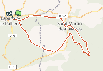
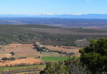
Ruta Senderismo de 11,4 km a descubrir en Provenza-Alpes-Costa Azul, Var, Esparron. Esta ruta ha sido propuesta por Greg813.
Descripción
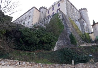
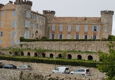
Petite boucle dans les forêts du haut Var, menant d'Esparron au château de St Martin de Pallières.
Localización
País:
France
Región :
Provenza-Alpes-Costa Azul
Departamento/provincia :
Var
Municipio :
Esparron
Localidad:
Unknown
Salida:(Dec)
Salida:(UTM)
730152 ; 4830473 (31T) N.
Comentarios
Excursiones cerca
![Excursión Senderismo Esparron - les Crêtes d'Artigues 21.12.2024 - Photo](https://media.geolcdn.com/t/375/260/0dbe2802-f98a-46b7-873b-ed4e20a02570.jpg&format=jpg&maxdim=2)
![Senderismo Senderismo](https://static1.geolcdn.com/sitytour/trail-icons/101.png)
les Crêtes d'Artigues 21.12.2024
Senderismo
Medio
Esparron,
Provenza-Alpes-Costa Azul,
Var,
France
![](/images/other/stat-length.png)
12,1 km | 17,8 km-effort
4h 0min
![](https://static1.geolcdn.com/siteimages/upload/files/16400158638029165_repeat_loop_refresh_sync_direction_icon.png)
Sí
![Excursión Senderismo Esparron - 2Esparron de Pallières à Saint Martin de Pallières, c'est le retour.. - Photo](https://media.geolcdn.com/t/375/260/b2254a91-b889-4165-b542-844166d8477d.jpg&format=jpg&maxdim=2)
![Senderismo Senderismo](https://static1.geolcdn.com/sitytour/trail-icons/101.png)
2Esparron de Pallières à Saint Martin de Pallières, c'est le retour..
Senderismo
Fácil
Esparron,
Provenza-Alpes-Costa Azul,
Var,
France
![](/images/other/stat-length.png)
4,8 km | 6 km-effort
1h 11min
![](https://static1.geolcdn.com/siteimages/upload/files/16400158638029165_repeat_loop_refresh_sync_direction_icon.png)
No
![Excursión Senderismo Saint-Martin-de-Pallières - La montagne d'Artigues 16-12-2020 - Photo](https://media.geolcdn.com/t/375/260/82c33139-e6d3-44c8-94c6-9c65127cee96.jpg&format=jpg&maxdim=2)
![Senderismo Senderismo](https://static1.geolcdn.com/sitytour/trail-icons/101.png)
La montagne d'Artigues 16-12-2020
Senderismo
Medio
Saint-Martin-de-Pallières,
Provenza-Alpes-Costa Azul,
Var,
France
![](/images/other/stat-length.png)
20 km | 28 km-effort
6h 2min
![](https://static1.geolcdn.com/siteimages/upload/files/16400158638029165_repeat_loop_refresh_sync_direction_icon.png)
Sí
![Excursión Senderismo Esparron - Saint Martin de Pallieres- Esparron de Pallieres - Photo](https://media.geolcdn.com/t/375/260/8685a498-1592-4459-a358-4717225e52fa.jpg&format=jpg&maxdim=2)
![Senderismo Senderismo](https://static1.geolcdn.com/sitytour/trail-icons/101.png)
Saint Martin de Pallieres- Esparron de Pallieres
Senderismo
Medio
(1)
Esparron,
Provenza-Alpes-Costa Azul,
Var,
France
![](/images/other/stat-length.png)
14,5 km | 19,2 km-effort
5h 33min
![](https://static1.geolcdn.com/siteimages/upload/files/16400158638029165_repeat_loop_refresh_sync_direction_icon.png)
Sí
![Excursión Senderismo Esparron - Esparron les Pallières Saint Martin 12 juin 2019 - Photo](https://media.geolcdn.com/t/375/260/fef9c74a-441d-45e4-81ad-dc170e2d092e.jpg&format=jpg&maxdim=2)
![Senderismo Senderismo](https://static1.geolcdn.com/sitytour/trail-icons/101.png)
Esparron les Pallières Saint Martin 12 juin 2019
Senderismo
Medio
Esparron,
Provenza-Alpes-Costa Azul,
Var,
France
![](/images/other/stat-length.png)
14,7 km | 19,5 km-effort
5h 41min
![](https://static1.geolcdn.com/siteimages/upload/files/16400158638029165_repeat_loop_refresh_sync_direction_icon.png)
Sí
![Excursión Senderismo Saint-Martin-de-Pallières - Routes des Crêtes - Photo](https://media.geolcdn.com/t/375/260/ext.jpg?maxdim=2&url=https%3A%2F%2Fservices.sitytrail.com%2FGeolivesWS%2FDownloadMedia.ashx%3FTrailID%3D936752%26Media%3Dfix__20180404174939.jpg)
![Senderismo Senderismo](https://static1.geolcdn.com/sitytour/trail-icons/101.png)
Routes des Crêtes
Senderismo
Fácil
Saint-Martin-de-Pallières,
Provenza-Alpes-Costa Azul,
Var,
France
![](/images/other/stat-length.png)
7,4 km | 9,8 km-effort
2h 7min
![](https://static1.geolcdn.com/siteimages/upload/files/16400158638029165_repeat_loop_refresh_sync_direction_icon.png)
Sí
![Excursión Senderismo Esparron - 2025-01-17 Les Crêtes d'Artigues - Photo](https://media.geolcdn.com/t/375/260/ext.jpg?maxdim=2&url=https%3A%2F%2Fstatic1.geolcdn.com%2Fsiteimages%2Fupload%2Ffiles%2F1553511878bg_sport_marche.png)
![Senderismo Senderismo](https://static1.geolcdn.com/sitytour/trail-icons/101.png)
2025-01-17 Les Crêtes d'Artigues
Senderismo
Medio
Esparron,
Provenza-Alpes-Costa Azul,
Var,
France
![](/images/other/stat-length.png)
14,4 km | 21 km-effort
4h 44min
![](https://static1.geolcdn.com/siteimages/upload/files/16400158638029165_repeat_loop_refresh_sync_direction_icon.png)
Sí
![Excursión Senderismo Rians - Mont Major 587m 15.12.24 - Photo](https://media.geolcdn.com/t/375/260/ext.jpg?maxdim=2&url=https%3A%2F%2Fstatic1.geolcdn.com%2Fsiteimages%2Fupload%2Ffiles%2F1553511878bg_sport_marche.png)
![Senderismo Senderismo](https://static1.geolcdn.com/sitytour/trail-icons/101.png)
Mont Major 587m 15.12.24
Senderismo
Fácil
Rians,
Provenza-Alpes-Costa Azul,
Var,
France
![](/images/other/stat-length.png)
8,2 km | 12 km-effort
2h 30min
![](https://static1.geolcdn.com/siteimages/upload/files/16400158638029165_repeat_loop_refresh_sync_direction_icon.png)
Sí
![Excursión Senderismo Esparron - Montagne d’Artigues , traversée intégrale par la crête - Photo](https://media.geolcdn.com/t/375/260/33f72e15-e42d-4a11-a384-6e79b92ed1ce.jpg&format=jpg&maxdim=2)
![Senderismo Senderismo](https://static1.geolcdn.com/sitytour/trail-icons/101.png)
Montagne d’Artigues , traversée intégrale par la crête
Senderismo
Difícil
Esparron,
Provenza-Alpes-Costa Azul,
Var,
France
![](/images/other/stat-length.png)
13,9 km | 20 km-effort
4h 39min
![](https://static1.geolcdn.com/siteimages/upload/files/16400158638029165_repeat_loop_refresh_sync_direction_icon.png)
Sí