![](/images/other/stat-length.png)
![Excursión Senderismo Sommervieu - bayeux arromanches - Photo](https://media.geolcdn.com/t/1900/400/ext.pjpeg?maxdim=2&url=https%3A%2F%2Fstatic1.geolcdn.com%2Fsiteimages%2Fupload%2Ffiles%2F1553511878bg_sport_marche.png)
bayeux arromanches
rollondesbois
Usuario
![Longitud](/images/other/stat-length.png)
Longitud
8,5 km
![Altitud máxima](https://static1.geolcdn.com/siteimages/upload/files/1508320355ic_sort_altitude_max_24dp.png)
Altitud máxima
57 m
![Desnivel positivo](https://static1.geolcdn.com/siteimages/upload/files/1508320355ic_sort_den_pos_24dp.png)
Desnivel positivo
95 m
![Km-Effort](/images/other/stat-length.png)
Km-Effort
9,8 km
![Altitud mínima](https://static1.geolcdn.com/siteimages/upload/files/1508320355ic_sort_altitude_min_24dp.png)
Altitud mínima
0 m
![Desnivel negativo](https://static1.geolcdn.com/siteimages/upload/files/1508320355ic_sort_den_neg_24dp.png)
Desnivel negativo
126 m
![Boucle](https://static1.geolcdn.com/siteimages/upload/files/16400158638029165_repeat_loop_refresh_sync_direction_icon.png)
Boucle
No
Fecha de creación :
2018-09-16 10:15:43.758
Última modificación :
2018-09-17 20:33:22.88
![Senderismo](https://static1.geolcdn.com/sitytour/trail-icons/101.png)
3h07
Dificultad : Muy fácil
![Escanee este código QR para abrir la excursión en la aplicación SityTrail](https://capi.geolives.com/qq0zvz2zws4bq2lad0pu/sitytour/trails/2010312/qr.png?size=200)
Aplicación GPS de excursión GRATIS
A propósito
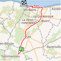
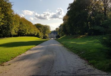
Ruta Senderismo de 8,5 km a descubrir en Normandía, Calvados, Sommervieu. Esta ruta ha sido propuesta por rollondesbois.
Descripción
Parking BioCoop.
Prévoir un véhicule au parking Gratuit d'Arromanches pour le retour.
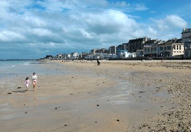
Ne pas oublier la baignade à l'arrivée.
Localización
País:
France
Región :
Normandía
Departamento/provincia :
Calvados
Municipio :
Sommervieu
Localidad:
Unknown
Salida:(Dec)
Salida:(UTM)
671634 ; 5462970 (30U) N.
Comentarios
Excursiones cerca
![Excursión Bicicleta Ryes - Petites routes du Bessin - Photo](https://media.geolcdn.com/t/375/260/ext.jpg?maxdim=2&url=https%3A%2F%2Fservices.sitytrail.com%2FGeolivesWS%2FDownloadMedia.ashx%3FTrailID%3D741984%26Media%3Dd424f3ff-7899-49e7-bff6-3ce0466f24fb.jpg)
![Bicicleta Bicicleta](https://static1.geolcdn.com/sitytour/trail-icons/200.png)
Petites routes du Bessin
Bicicleta
Medio
Ryes,
Normandía,
Calvados,
France
![](/images/other/stat-length.png)
64 km | 71 km-effort
4h 6min
![](https://static1.geolcdn.com/siteimages/upload/files/16400158638029165_repeat_loop_refresh_sync_direction_icon.png)
Sí
![Excursión Senderismo Ryes - Ryes-Bazenville-Ryes - Photo](https://media.geolcdn.com/t/375/260/ext.jpg?maxdim=2&url=https%3A%2F%2Fservices.sitytrail.com%2FGeolivesWS%2FDownloadMedia.ashx%3FTrailID%3D736315%26Media%3De11c7be8-a637-4828-bcc7-504555823948.jpg)
![Senderismo Senderismo](https://static1.geolcdn.com/sitytour/trail-icons/101.png)
Ryes-Bazenville-Ryes
Senderismo
Fácil
Ryes,
Normandía,
Calvados,
France
![](/images/other/stat-length.png)
11,2 km | 12,6 km-effort
2h 47min
![](https://static1.geolcdn.com/siteimages/upload/files/16400158638029165_repeat_loop_refresh_sync_direction_icon.png)
Sí
![Excursión Senderismo Ryes - Ryes Arromanches Les Monts - Photo](https://media.geolcdn.com/t/375/260/ext.jpg?maxdim=2&url=https%3A%2F%2Fservices.sitytrail.com%2FGeolivesWS%2FDownloadMedia.ashx%3FTrailID%3D735954%26Media%3D7c0dec61-404a-4e9a-9583-28cafb5dcd89.jpg)
![Senderismo Senderismo](https://static1.geolcdn.com/sitytour/trail-icons/101.png)
Ryes Arromanches Les Monts
Senderismo
Medio
Ryes,
Normandía,
Calvados,
France
![](/images/other/stat-length.png)
15,6 km | 18,1 km-effort
3h 58min
![](https://static1.geolcdn.com/siteimages/upload/files/16400158638029165_repeat_loop_refresh_sync_direction_icon.png)
Sí
![Excursión Senderismo Vienne-en-Bessin - Vienne en Bessin-St Gabriel A-R - Photo](https://media.geolcdn.com/t/375/260/ext.jpg?maxdim=2&url=https%3A%2F%2Fservices.sitytrail.com%2FGeolivesWS%2FDownloadMedia.ashx%3FTrailID%3D721258%26Media%3Dfix__20170326152950.jpg)
![Senderismo Senderismo](https://static1.geolcdn.com/sitytour/trail-icons/101.png)
Vienne en Bessin-St Gabriel A-R
Senderismo
Muy fácil
Vienne-en-Bessin,
Normandía,
Calvados,
France
![](/images/other/stat-length.png)
8,2 km | 9,3 km-effort
1h 48min
![](https://static1.geolcdn.com/siteimages/upload/files/16400158638029165_repeat_loop_refresh_sync_direction_icon.png)
Sí
![Excursión Senderismo Arromanches-les-Bains - Arromanches Luc - Photo](https://media.geolcdn.com/t/375/260/ext.jpg?maxdim=2&url=https%3A%2F%2Fservices.sitytrail.com%2FGeolivesWS%2FDownloadMedia.ashx%3FTrailID%3D419397%26Media%3Dfix__20150509172322.jpg)
![Senderismo Senderismo](https://static1.geolcdn.com/sitytour/trail-icons/101.png)
Arromanches Luc
Senderismo
Fácil
Arromanches-les-Bains,
Normandía,
Calvados,
France
![](/images/other/stat-length.png)
25 km | 26 km-effort
5h 46min
![](https://static1.geolcdn.com/siteimages/upload/files/16400158638029165_repeat_loop_refresh_sync_direction_icon.png)
No
![Excursión Senderismo Bayeux - Bayeux Arromanches - Photo](https://media.geolcdn.com/t/375/260/ext.jpg?maxdim=2&url=https%3A%2F%2Fservices.sitytrail.com%2FGeolivesWS%2FDownloadMedia.ashx%3FTrailID%3D419380%26Media%3Dfix__20150508134430.jpg)
![Senderismo Senderismo](https://static1.geolcdn.com/sitytour/trail-icons/101.png)
Bayeux Arromanches
Senderismo
Fácil
Bayeux,
Normandía,
Calvados,
France
![](/images/other/stat-length.png)
14,1 km | 16,7 km-effort
3h 36min
![](https://static1.geolcdn.com/siteimages/upload/files/16400158638029165_repeat_loop_refresh_sync_direction_icon.png)
No
![Excursión Bici de montaña Saint-Vigor-le-Grand - Plateau d'Equay au Val de Seulles - St Vigor le Grand - Photo](https://media.geolcdn.com/t/375/260/ext.jpg?maxdim=2&url=https%3A%2F%2Fservices.sitytrail.com%2FGeolivesWS%2FDownloadMedia.ashx%3FTrailID%3D316823%26Media%3D15880_4.jpg)
![Bici de montaña Bici de montaña](https://static1.geolcdn.com/sitytour/trail-icons/202.png)
Plateau d'Equay au Val de Seulles - St Vigor le Grand
Bici de montaña
Medio
Saint-Vigor-le-Grand,
Normandía,
Calvados,
France
![](/images/other/stat-length.png)
18,5 km | 21 km-effort
1h 15min
![](https://static1.geolcdn.com/siteimages/upload/files/16400158638029165_repeat_loop_refresh_sync_direction_icon.png)
Sí
![Excursión Senderismo Saint-Côme-de-Fresné - st Côme de frene - Photo](https://media.geolcdn.com/t/375/260/74056382-3acc-4bfd-a0b3-334cec625230.jpg&format=jpg&maxdim=2)
![Senderismo Senderismo](https://static1.geolcdn.com/sitytour/trail-icons/101.png)
st Côme de frene
Senderismo
Medio
Saint-Côme-de-Fresné,
Normandía,
Calvados,
France
![](/images/other/stat-length.png)
7 km | 9 km-effort
1h 54min
![](https://static1.geolcdn.com/siteimages/upload/files/16400158638029165_repeat_loop_refresh_sync_direction_icon.png)
Sí
![Excursión Bici de montaña Vienne-en-Bessin - Saint Gabriel /pierrepont /amblie - Photo](https://media.geolcdn.com/t/375/260/99d4d45e-373f-4d16-9281-98c4130c2152.jpg&format=jpg&maxdim=2)
![Bici de montaña Bici de montaña](https://static1.geolcdn.com/sitytour/trail-icons/202.png)
Saint Gabriel /pierrepont /amblie
Bici de montaña
Muy fácil
Vienne-en-Bessin,
Normandía,
Calvados,
France
![](/images/other/stat-length.png)
28 km | 31 km-effort
2h 17min
![](https://static1.geolcdn.com/siteimages/upload/files/16400158638029165_repeat_loop_refresh_sync_direction_icon.png)
Sí