![](/images/other/stat-length.png)
![Excursión Bici de carretera Blandy - Château en Brie Centrale - Photo](https://media.geolcdn.com/t/1900/400/ext.pjpeg?maxdim=2&url=https%3A%2F%2Fstatic1.geolcdn.com%2Fsiteimages%2Fupload%2Ffiles%2F1524743154velo.jpg)
Château en Brie Centrale
csy95
Usuario
![Longitud](/images/other/stat-length.png)
![Altitud máxima](https://static1.geolcdn.com/siteimages/upload/files/1508320355ic_sort_altitude_max_24dp.png)
![Desnivel positivo](https://static1.geolcdn.com/siteimages/upload/files/1508320355ic_sort_den_pos_24dp.png)
![Km-Effort](/images/other/stat-length.png)
![Altitud mínima](https://static1.geolcdn.com/siteimages/upload/files/1508320355ic_sort_altitude_min_24dp.png)
![Desnivel negativo](https://static1.geolcdn.com/siteimages/upload/files/1508320355ic_sort_den_neg_24dp.png)
![Boucle](https://static1.geolcdn.com/siteimages/upload/files/16400158638029165_repeat_loop_refresh_sync_direction_icon.png)
![Bici de carretera](https://static1.geolcdn.com/sitytour/trail-icons/201.png)
2h18
Dificultad : Fácil
![Escanee este código QR para abrir la excursión en la aplicación SityTrail](https://capi.geolives.com/qq0zvz2zws4bq2lad0pu/sitytour/trails/2010222/qr.png?size=200)
Aplicación GPS de excursión GRATIS
A propósito
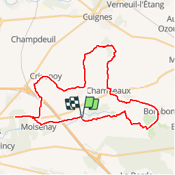
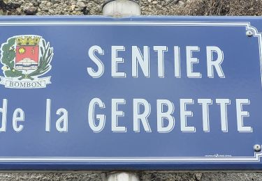
Ruta Bici de carretera de 36 km a descubrir en Isla de Francia, Sena y Marne, Blandy. Esta ruta ha sido propuesta por csy95.
Descripción
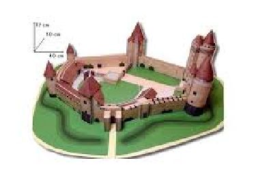
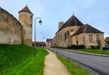
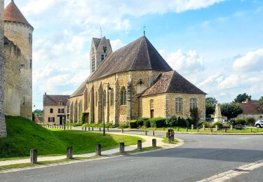
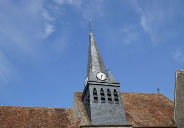
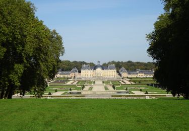
Blandy-les-Tours : Charmant village Briard. Vous découvrez l’un des plus beaux château-fort qui figure parmi les derniers témoins d’architecture du XIVème siècle conservés en île-de-France. Le château monument historique est désormais, la propriété du Département qui le restaure depuis 1992. Visitez l’église Saint-Maurice, édifiée au 14ème et agrandie au 16ème siècle, bâtie sur l’emplacement d’un ancien cimetière mérovingien. Remarquer le broyeur à pommes sur la place du Colombier. Vaux-le-Vicomte : Chef d’œuvre du XVIIe siècle, c’est le château de Nicolas Fouquet, Surintendant des finances de Louis XIV, fruit du travail de 3 artistes talentueux, Le Vau, Le Brun et Le Nôtre. Une architecture remarquable et innovante de Louis Le Vau, des décors splendides de Charles Le Brun le peintre et décorateur, et le premier grand jardin à la française imaginé par le célèbre jardinier-paysagiste André Le Nôtre. Un petit bijou que Nicolas Fouquet voulut inaugurer le 17 août 1661, en présence du Roi Soleil. Vaux-le-Vicomte est l’un des rares châteaux que l’on visite entièrement, depuis les caves et les cuisines jusqu’aux charpentes menant aux Dômes. Toutes les pièces sont richement meublées et décorées. Enfin, une collection d’attelages de toute beauté dans les anciennes écuries fera briller les yeux de tous les nostalgiques des voyages d’antan. Andrezel : Le pape Martin IV (Simon de Brion) est né vers 1210/1220 à la ferme de Mainpincien sur le territoire de la commune d’Andrezel. Champeaux : Vous visiterez la Collégiale Saint-Martin, classée en 1942 au titre des monuments historiques. L’intérieur fut commencé vers 1160 et terminé vers 1315. La majorité des vitraux du XVIème siècle qui les décorent furent l’œuvre des maîtres verriers melunais. La cloche « Marie » date de 1730.
Localización
Comentarios
Excursiones cerca
![Excursión Senderismo Blandy - Eglises Médiévales de la Brie - La Collégiale Saint-Martin de Champeaux - Photo](https://media.geolcdn.com/t/375/260/aed965fb-0abe-4a92-b759-defb35e3ca63.jpg&format=jpg&maxdim=2)
![Senderismo Senderismo](https://static1.geolcdn.com/sitytour/trail-icons/101.png)
Senderismo
![](/images/other/stat-length.png)
![](https://static1.geolcdn.com/siteimages/upload/files/16400158638029165_repeat_loop_refresh_sync_direction_icon.png)
![Excursión Senderismo Blandy - Boucle 23 km Blandy - St Merry - Bombon - Champeaux - Photo](https://media.geolcdn.com/t/375/260/810a2001-48d6-47b8-9b9c-600abddda76e.jpg&format=jpg&maxdim=2)
![Senderismo Senderismo](https://static1.geolcdn.com/sitytour/trail-icons/101.png)
Senderismo
![](/images/other/stat-length.png)
![](https://static1.geolcdn.com/siteimages/upload/files/16400158638029165_repeat_loop_refresh_sync_direction_icon.png)
![Excursión Senderismo Blandy - Boucle 21 km Blandy - Bombom - St Mery - Champeaux - Photo](https://media.geolcdn.com/t/375/260/a365a7e1-c890-4e35-bd6d-01d4e699b3cc.jpg&format=jpg&maxdim=2)
![Senderismo Senderismo](https://static1.geolcdn.com/sitytour/trail-icons/101.png)
Senderismo
![](/images/other/stat-length.png)
![](https://static1.geolcdn.com/siteimages/upload/files/16400158638029165_repeat_loop_refresh_sync_direction_icon.png)
![Excursión Senderismo Blandy - Boucle autour de Blandy par Corinne - Photo](https://media.geolcdn.com/t/375/260/e1753442-473d-4613-9ca0-8082f000c750.jpg&format=jpg&maxdim=2)
![Senderismo Senderismo](https://static1.geolcdn.com/sitytour/trail-icons/101.png)
Senderismo
![](/images/other/stat-length.png)
![](https://static1.geolcdn.com/siteimages/upload/files/16400158638029165_repeat_loop_refresh_sync_direction_icon.png)
![Excursión Senderismo Blandy - De Maincy à Blandy les Tours - Photo](https://media.geolcdn.com/t/375/260/ext.jpg?maxdim=2&url=https%3A%2F%2Fstatic1.geolcdn.com%2Fsiteimages%2Fupload%2Ffiles%2F1553511878bg_sport_marche.png)
![Senderismo Senderismo](https://static1.geolcdn.com/sitytour/trail-icons/101.png)
Senderismo
![](/images/other/stat-length.png)
![](https://static1.geolcdn.com/siteimages/upload/files/16400158638029165_repeat_loop_refresh_sync_direction_icon.png)
![Excursión Senderismo Saint-Méry - Boucle autour de Saint Mery 20 km - Photo](https://media.geolcdn.com/t/375/260/8aa4e70e-d8ab-4b1b-897f-cd1520e1f018.jpg&format=jpg&maxdim=2)
![Senderismo Senderismo](https://static1.geolcdn.com/sitytour/trail-icons/101.png)
Senderismo
![](/images/other/stat-length.png)
![](https://static1.geolcdn.com/siteimages/upload/files/16400158638029165_repeat_loop_refresh_sync_direction_icon.png)
![Excursión Senderismo Maincy - vaux le pénil - blandy les tours - Photo](https://media.geolcdn.com/t/375/260/5344f78f-37de-4136-b4f8-4ce06f4e96e0.jpg&format=jpg&maxdim=2)
![Senderismo Senderismo](https://static1.geolcdn.com/sitytour/trail-icons/101.png)
Senderismo
![](/images/other/stat-length.png)
![](https://static1.geolcdn.com/siteimages/upload/files/16400158638029165_repeat_loop_refresh_sync_direction_icon.png)
![Excursión Senderismo Maincy - 3 chateaux - Photo](https://media.geolcdn.com/t/375/260/292423c5-20b3-4ed0-abe4-a1a9ed13f5c8.jpg&format=jpg&maxdim=2)
![Senderismo Senderismo](https://static1.geolcdn.com/sitytour/trail-icons/101.png)
Senderismo
![](/images/other/stat-length.png)
![](https://static1.geolcdn.com/siteimages/upload/files/16400158638029165_repeat_loop_refresh_sync_direction_icon.png)
![Senderismo Senderismo](https://static1.geolcdn.com/sitytour/trail-icons/101.png)
Senderismo
![](/images/other/stat-length.png)
![](https://static1.geolcdn.com/siteimages/upload/files/16400158638029165_repeat_loop_refresh_sync_direction_icon.png)