![](/images/other/stat-length.png)
![Excursión Senderismo Apremont - 180823-Pierre Hâchée - Photo](https://media.geolcdn.com/t/1900/400/1bd122ea-55eb-4885-b5a8-f907a50842fc.jpg&format=pjpeg&maxdim=2)
180823-Pierre Hâchée
Jfumomo
Usuario
![Longitud](/images/other/stat-length.png)
Longitud
6,9 km
![Altitud máxima](https://static1.geolcdn.com/siteimages/upload/files/1508320355ic_sort_altitude_max_24dp.png)
Altitud máxima
372 m
![Desnivel positivo](https://static1.geolcdn.com/siteimages/upload/files/1508320355ic_sort_den_pos_24dp.png)
Desnivel positivo
69 m
![Km-Effort](/images/other/stat-length.png)
Km-Effort
7,8 km
![Altitud mínima](https://static1.geolcdn.com/siteimages/upload/files/1508320355ic_sort_altitude_min_24dp.png)
Altitud mínima
322 m
![Desnivel negativo](https://static1.geolcdn.com/siteimages/upload/files/1508320355ic_sort_den_neg_24dp.png)
Desnivel negativo
69 m
![Boucle](https://static1.geolcdn.com/siteimages/upload/files/16400158638029165_repeat_loop_refresh_sync_direction_icon.png)
Boucle
Sí
Fecha de creación :
2018-08-23 07:12:38.306
Última modificación :
2018-08-23 15:28:36.045
![Senderismo](https://static1.geolcdn.com/sitytour/trail-icons/101.png)
1h19
Dificultad : Fácil
![Escanee este código QR para abrir la excursión en la aplicación SityTrail](https://capi.geolives.com/qq0zvz2zws4bq2lad0pu/sitytour/trails/2008023/qr.png?size=200)
Aplicación GPS de excursión GRATIS
A propósito
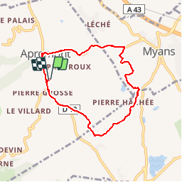
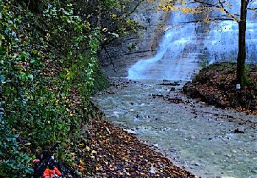
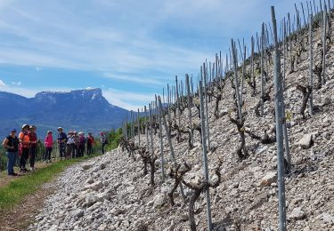
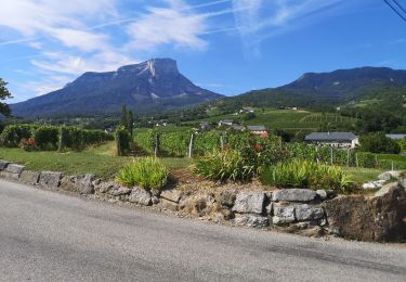
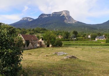
Ruta Senderismo de 6,9 km a descubrir en Auvergne-Rhône-Alpes, Saboya, Apremont. Esta ruta ha sido propuesta por Jfumomo.
Descripción
Pierre Grosse, Chemin des Fontanettes, Lac des Pères, Chemin de la Caspienne, Route de Myans
Localización
País:
France
Región :
Auvergne-Rhône-Alpes
Departamento/provincia :
Saboya
Municipio :
Apremont
Localidad:
Unknown
Salida:(Dec)
Salida:(UTM)
731269 ; 5043731 (31T) N.
Comentarios
Excursiones cerca
![Excursión Senderismo Apremont - Mont Joigny, pte de la Georgat, la Lentille, le GD Carroz - Photo](https://media.geolcdn.com/t/375/260/34a799f3-15e1-4e29-b39c-0c906d59ce42.jpg&format=jpg&maxdim=2)
![Senderismo Senderismo](https://static1.geolcdn.com/sitytour/trail-icons/101.png)
Mont Joigny, pte de la Georgat, la Lentille, le GD Carroz
Senderismo
Fácil
(1)
Apremont,
Auvergne-Rhône-Alpes,
Saboya,
France
![](/images/other/stat-length.png)
12,7 km | 23 km-effort
4h 3min
![](https://static1.geolcdn.com/siteimages/upload/files/16400158638029165_repeat_loop_refresh_sync_direction_icon.png)
Sí
![Excursión Senderismo Entremont-le-Vieux - Le Mont Granier par la cheminée de Tencovaz - Photo](https://media.geolcdn.com/t/375/260/ext.jpg?maxdim=2&url=https%3A%2F%2Fservices.sitytrail.com%2FGeolivesWS%2FDownloadMedia.ashx%3FTrailID%3D103708%26Media%3D6232_1.jpg)
![Senderismo Senderismo](https://static1.geolcdn.com/sitytour/trail-icons/101.png)
Le Mont Granier par la cheminée de Tencovaz
Senderismo
Difícil
(3)
Entremont-le-Vieux,
Auvergne-Rhône-Alpes,
Saboya,
France
![](/images/other/stat-length.png)
9,6 km | 24 km-effort
5h 0min
![](https://static1.geolcdn.com/siteimages/upload/files/16400158638029165_repeat_loop_refresh_sync_direction_icon.png)
Sí
![Excursión Senderismo Chapareillan - Le Granier 1933m, par les pas de la Porte et de Bellecombe - Photo](https://media.geolcdn.com/t/375/260/ext.jpg?maxdim=2&url=https%3A%2F%2Fservices.sitytrail.com%2FGeolivesWS%2FDownloadMedia.ashx%3FTrailID%3D102833%26Media%3D3997_1.jpg)
![Senderismo Senderismo](https://static1.geolcdn.com/sitytour/trail-icons/101.png)
Le Granier 1933m, par les pas de la Porte et de Bellecombe
Senderismo
Difícil
(1)
Chapareillan,
Auvergne-Rhône-Alpes,
Isère,
France
![](/images/other/stat-length.png)
13,2 km | 30 km-effort
7h 30min
![](https://static1.geolcdn.com/siteimages/upload/files/16400158638029165_repeat_loop_refresh_sync_direction_icon.png)
Sí
![Excursión Senderismo Porte-de-Savoie - lac noir - Photo](https://media.geolcdn.com/t/375/260/499f9890-28e0-48a3-ad89-8f41232ea1db.jpg&format=jpg&maxdim=2)
![Senderismo Senderismo](https://static1.geolcdn.com/sitytour/trail-icons/101.png)
lac noir
Senderismo
Medio
(1)
Porte-de-Savoie,
Auvergne-Rhône-Alpes,
Saboya,
France
![](/images/other/stat-length.png)
15,8 km | 22 km-effort
5h 9min
![](https://static1.geolcdn.com/siteimages/upload/files/16400158638029165_repeat_loop_refresh_sync_direction_icon.png)
Sí
![Bici de montaña Bici de montaña](https://static1.geolcdn.com/sitytour/trail-icons/202.png)
Les coteaux d'Apremont
Bici de montaña
Difícil
Porte-de-Savoie,
Auvergne-Rhône-Alpes,
Saboya,
France
![](/images/other/stat-length.png)
27 km | 37 km-effort
2h 32min
![](https://static1.geolcdn.com/siteimages/upload/files/16400158638029165_repeat_loop_refresh_sync_direction_icon.png)
Sí
![Excursión Marcha nórdica Chignin - Chignin - Arbin à travers les vignes et coteaux - Photo](https://media.geolcdn.com/t/375/260/57c2a674-7c91-4476-9328-bd442983023e.jpg&format=jpg&maxdim=2)
![Marcha nórdica Marcha nórdica](https://static1.geolcdn.com/sitytour/trail-icons/102.png)
Chignin - Arbin à travers les vignes et coteaux
Marcha nórdica
Medio
Chignin,
Auvergne-Rhône-Alpes,
Saboya,
France
![](/images/other/stat-length.png)
15,2 km | 21 km-effort
3h 36min
![](https://static1.geolcdn.com/siteimages/upload/files/16400158638029165_repeat_loop_refresh_sync_direction_icon.png)
Sí
![Excursión Senderismo Apremont - 20190830 - Golf et Lac des Pères - Photo](https://media.geolcdn.com/t/375/260/34747fae-a240-48da-af1e-c5fd73f2ee52.jpg&format=jpg&maxdim=2)
![Senderismo Senderismo](https://static1.geolcdn.com/sitytour/trail-icons/101.png)
20190830 - Golf et Lac des Pères
Senderismo
Fácil
Apremont,
Auvergne-Rhône-Alpes,
Saboya,
France
![](/images/other/stat-length.png)
6,8 km | 7,4 km-effort
1h 15min
![](https://static1.geolcdn.com/siteimages/upload/files/16400158638029165_repeat_loop_refresh_sync_direction_icon.png)
Sí
![Excursión Senderismo Apremont - 20190816 - Bélisay (Myans) - Photo](https://media.geolcdn.com/t/375/260/afaf4216-858a-4b40-95ec-5ccdfc1a4901.jpg&format=jpg&maxdim=2)
![Senderismo Senderismo](https://static1.geolcdn.com/sitytour/trail-icons/101.png)
20190816 - Bélisay (Myans)
Senderismo
Medio
Apremont,
Auvergne-Rhône-Alpes,
Saboya,
France
![](/images/other/stat-length.png)
8,3 km | 9,3 km-effort
1h 35min
![](https://static1.geolcdn.com/siteimages/upload/files/16400158638029165_repeat_loop_refresh_sync_direction_icon.png)
Sí
![Excursión Senderismo Apremont - 20190814 - Lac Saint André - Photo](https://media.geolcdn.com/t/375/260/83860ba6-a9df-487a-a16d-c6a30d872cc1.jpg&format=jpg&maxdim=2)
![Senderismo Senderismo](https://static1.geolcdn.com/sitytour/trail-icons/101.png)
20190814 - Lac Saint André
Senderismo
Fácil
Apremont,
Auvergne-Rhône-Alpes,
Saboya,
France
![](/images/other/stat-length.png)
7,9 km | 9,5 km-effort
1h 36min
![](https://static1.geolcdn.com/siteimages/upload/files/16400158638029165_repeat_loop_refresh_sync_direction_icon.png)
Sí