![](/images/other/stat-length.png)
![Excursión Bicicleta híbrida Rochefort - Rondje-Rochefort-52km - Photo](https://media.geolcdn.com/t/1900/400/ca0cca25-e59a-4b3a-a6fa-536f7d4a4c6f.jpg&format=pjpeg&maxdim=2)
Rondje-Rochefort-52km
jeanphi.hennebert
Usuario
![Longitud](/images/other/stat-length.png)
Longitud
48 km
![Altitud máxima](https://static1.geolcdn.com/siteimages/upload/files/1508320355ic_sort_altitude_max_24dp.png)
Altitud máxima
312 m
![Desnivel positivo](https://static1.geolcdn.com/siteimages/upload/files/1508320355ic_sort_den_pos_24dp.png)
Desnivel positivo
658 m
![Km-Effort](/images/other/stat-length.png)
Km-Effort
57 km
![Altitud mínima](https://static1.geolcdn.com/siteimages/upload/files/1508320355ic_sort_altitude_min_24dp.png)
Altitud mínima
145 m
![Desnivel negativo](https://static1.geolcdn.com/siteimages/upload/files/1508320355ic_sort_den_neg_24dp.png)
Desnivel negativo
658 m
![Boucle](https://static1.geolcdn.com/siteimages/upload/files/16400158638029165_repeat_loop_refresh_sync_direction_icon.png)
Boucle
Sí
Fecha de creación :
2018-07-31 10:47:18.381
Última modificación :
2018-08-06 10:55:01.843
![Bicicleta híbrida](https://static1.geolcdn.com/sitytour/trail-icons/203.png)
6h00
Dificultad : Difícil
![Bici eléctrica](https://static1.geolcdn.com/sitytour/trail-icons/205.png)
6h00
Dificultad : Difícil
![Escanee este código QR para abrir la excursión en la aplicación SityTrail](https://capi.geolives.com/qq0zvz2zws4bq2lad0pu/sitytour/trails/2004677/qr.png?size=200)
Aplicación GPS de excursión GRATIS
A propósito
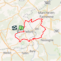
Ruta Bicicleta híbrida de 48 km a descubrir en Valonia, Namur, Rochefort. Esta ruta ha sido propuesta por jeanphi.hennebert.
Descripción
Une journée sportive.
Les 10 derniers kms de Havrenne à Eprave sont en descente ou plat, je l'ai faite sans difficulté avec des vélos électriques les batteries vides (30 kg)
Puntos de interés
Localización
País:
Belgium
Región :
Valonia
Departamento/provincia :
Namur
Municipio :
Rochefort
Localidad:
Éprave
Salida:(Dec)
Salida:(UTM)
655496 ; 5558121 (31U) N.
Comentarios
Excursiones cerca
![Excursión Senderismo Rochefort - Walk along the river Lesse and through bucolic landscapes - Photo](https://media.geolcdn.com/t/375/260/ext.jpg?maxdim=2&url=https%3A%2F%2Fservices.sitytrail.com%2FGeolivesWS%2FDownloadMedia.ashx%3FTrailID%3D217391%26Media%3Df70ecdda-41e6-4428-8538-20d80ba8d70d.jpg)
![Senderismo Senderismo](https://static1.geolcdn.com/sitytour/trail-icons/101.png)
Walk along the river Lesse and through bucolic landscapes
Senderismo
Fácil
(7)
Rochefort,
Valonia,
Namur,
Belgium
![](/images/other/stat-length.png)
9,5 km | 11,3 km-effort
2h 28min
![](https://static1.geolcdn.com/siteimages/upload/files/16400158638029165_repeat_loop_refresh_sync_direction_icon.png)
Sí
![Excursión Senderismo Rochefort - Havrenne & de Saint-Remy Trappist Abbey - Photo](https://media.geolcdn.com/t/375/260/ext.jpg?maxdim=2&url=https%3A%2F%2Fservices.sitytrail.com%2FGeolivesWS%2FDownloadMedia.ashx%3FTrailID%3D215623%26Media%3Db529a95c-404d-4caa-9c09-6087624067bf.tif)
![Senderismo Senderismo](https://static1.geolcdn.com/sitytour/trail-icons/101.png)
Havrenne & de Saint-Remy Trappist Abbey
Senderismo
Fácil
(14)
Rochefort,
Valonia,
Namur,
Belgium
![](/images/other/stat-length.png)
6 km | 7,1 km-effort
2h 0min
![](https://static1.geolcdn.com/siteimages/upload/files/16400158638029165_repeat_loop_refresh_sync_direction_icon.png)
Sí
![Excursión Senderismo Rochefort - Nature - The view from the Belvédère in Han-sur-Lesse - Photo](https://media.geolcdn.com/t/375/260/ext.jpg?maxdim=2&url=https%3A%2F%2Fservices.sitytrail.com%2FGeolivesWS%2FDownloadMedia.ashx%3FTrailID%3D193579%26Media%3D5797bc56-5327-4c2b-b581-d88d672bf775.jpg)
![Senderismo Senderismo](https://static1.geolcdn.com/sitytour/trail-icons/101.png)
Nature - The view from the Belvédère in Han-sur-Lesse
Senderismo
Difícil
(16)
Rochefort,
Valonia,
Namur,
Belgium
![](/images/other/stat-length.png)
4,8 km | 6,3 km-effort
1h 20min
![](https://static1.geolcdn.com/siteimages/upload/files/16400158638029165_repeat_loop_refresh_sync_direction_icon.png)
Sí
![Excursión Motor Rochefort - Car tour - Heritage : churches, chapels and abbeys - Rochefort - Photo](https://media.geolcdn.com/t/375/260/ext.jpg?maxdim=2&url=https%3A%2F%2Fservices.sitytrail.com%2FGeolivesWS%2FDownloadMedia.ashx%3FTrailID%3D153103%26Media%3D05603f1b-9f7c-481f-bc84-6cc819555dbb.jpg)
![Motor Motor](https://static1.geolcdn.com/sitytour/trail-icons/400.png)
Car tour - Heritage : churches, chapels and abbeys - Rochefort
Motor
Fácil
(5)
Rochefort,
Valonia,
Namur,
Belgium
![](/images/other/stat-length.png)
65 km | 78 km-effort
2h 40min
![](https://static1.geolcdn.com/siteimages/upload/files/16400158638029165_repeat_loop_refresh_sync_direction_icon.png)
Sí
![Excursión Senderismo Rochefort - Nature walk discovering Villers-sur-Lesse, Eprave & Lessive - Photo](https://media.geolcdn.com/t/375/260/ext.jpg?maxdim=2&url=https%3A%2F%2Fservices.sitytrail.com%2FGeolivesWS%2FDownloadMedia.ashx%3FTrailID%3D148987%26Media%3D708a67c2-cf61-4529-a479-a432b14c8d29.jpg)
![Senderismo Senderismo](https://static1.geolcdn.com/sitytour/trail-icons/101.png)
Nature walk discovering Villers-sur-Lesse, Eprave & Lessive
Senderismo
Fácil
(15)
Rochefort,
Valonia,
Namur,
Belgium
![](/images/other/stat-length.png)
9,2 km | 10,3 km-effort
2h 18min
![](https://static1.geolcdn.com/siteimages/upload/files/16400158638029165_repeat_loop_refresh_sync_direction_icon.png)
Sí
![Excursión Senderismo Rochefort - RB-Na-07 Raccourci - Ronde au pays des grottes - Photo](https://media.geolcdn.com/t/375/260/ext.jpg?maxdim=2&url=https%3A%2F%2Fservices.sitytrail.com%2FGeolivesWS%2FDownloadMedia.ashx%3FTrailID%3D213757%26Media%3D27dc9085-0323-4669-9df4-56be0512bfe6.jpg)
![Senderismo Senderismo](https://static1.geolcdn.com/sitytour/trail-icons/101.png)
RB-Na-07 Raccourci - Ronde au pays des grottes
Senderismo
Fácil
(9)
Rochefort,
Valonia,
Namur,
Belgium
![](/images/other/stat-length.png)
18,4 km | 24 km-effort
4h 59min
![](https://static1.geolcdn.com/siteimages/upload/files/16400158638029165_repeat_loop_refresh_sync_direction_icon.png)
Sí
![Excursión Senderismo Rochefort - Nature - A discovery trail through Han-sur-Lesse - Photo](https://media.geolcdn.com/t/375/260/ext.jpg?maxdim=2&url=https%3A%2F%2Fservices.sitytrail.com%2FGeolivesWS%2FDownloadMedia.ashx%3FTrailID%3D148989%26Media%3D3c202c2f-ee01-4903-bd25-24913ec8637b.jpg)
![Senderismo Senderismo](https://static1.geolcdn.com/sitytour/trail-icons/101.png)
Nature - A discovery trail through Han-sur-Lesse
Senderismo
Muy fácil
(15)
Rochefort,
Valonia,
Namur,
Belgium
![](/images/other/stat-length.png)
4,8 km | 5,8 km-effort
1h 15min
![](https://static1.geolcdn.com/siteimages/upload/files/16400158638029165_repeat_loop_refresh_sync_direction_icon.png)
Sí
![Excursión Motor Rochefort - Roadbook](https://media.geolcdn.com/t/375/260/ext.jpg?maxdim=2&url=https%3A%2F%2Fservices.sitytrail.com%2FGeolivesWS%2FDownloadMedia.ashx%3FTrailID%3D428715%26Media%3Dff47641a-75c9-4285-926b-b7008d6e40b8.png)
![Motor Motor](https://static1.geolcdn.com/sitytour/trail-icons/400.png)
Roadbook "On the road by car/motorbike" - "Local delicacies, crafts and tradi...
Motor
Muy fácil
(3)
Rochefort,
Valonia,
Namur,
Belgium
![](/images/other/stat-length.png)
140 km | 169 km-effort
2h 0min
![](https://static1.geolcdn.com/siteimages/upload/files/16400158638029165_repeat_loop_refresh_sync_direction_icon.png)
Sí
![Excursión Bicicleta Rochefort - Cycling through Han-sur-Lesse/Belvaux/Auffe/Lessive/Eprave/Lessive/Villers/RAVeL/Han-sur-Lesse - Photo](https://media.geolcdn.com/t/375/260/ext.jpg?maxdim=2&url=https%3A%2F%2Fservices.sitytrail.com%2FGeolivesWS%2FDownloadMedia.ashx%3FTrailID%3D241702%26Media%3Da3c6a337-73d1-48ec-a2b2-5b885ffafa2a.jpg)
![Bicicleta Bicicleta](https://static1.geolcdn.com/sitytour/trail-icons/200.png)
Cycling through Han-sur-Lesse/Belvaux/Auffe/Lessive/Eprave/Lessive/Villers/RA...
Bicicleta
Fácil
(2)
Rochefort,
Valonia,
Namur,
Belgium
![](/images/other/stat-length.png)
29 km | 33 km-effort
1h 57min
![](https://static1.geolcdn.com/siteimages/upload/files/16400158638029165_repeat_loop_refresh_sync_direction_icon.png)
Sí