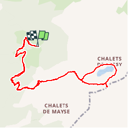
![](/images/other/stat-length.png)
![Excursión Senderismo Glières-Val-de-Borne - Tour du lac de Lessy depuis Paradis - Photo](https://media.geolcdn.com/t/1900/400/fb3c002f-0fad-4215-9eb6-d3a4d24b0e71.jpg&format=pjpeg&maxdim=2)
Tour du lac de Lessy depuis Paradis
thierryj0
Usuario
![Longitud](/images/other/stat-length.png)
![Boucle](https://static1.geolcdn.com/siteimages/upload/files/16400158638029165_repeat_loop_refresh_sync_direction_icon.png)
![Senderismo](https://static1.geolcdn.com/sitytour/trail-icons/101.png)
4h13
Dificultad : Medio
![Escanee este código QR para abrir la excursión en la aplicación SityTrail](https://capi.geolives.com/qq0zvz2zws4bq2lad0pu/sitytour/trails/2003821/qr.png?size=200)
Aplicación GPS de excursión GRATIS
A propósito
Ruta Senderismo de 13,8 km a descubrir en Auvergne-Rhône-Alpes, Alta Saboya, Glières-Val-de-Borne. Esta ruta ha sido propuesta por thierryj0.
Descripción
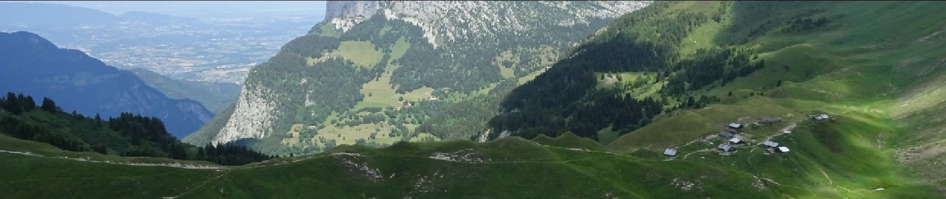
Sympathique rando, sans difficulté particulière. Cependant par temps humide, le début de la partie qui relie le col de la Forclaz au col 1902m (sous l'Aiguille Verte) peut devenir inconfortable (quelques passages terreux en dévers)
Localización
Comentarios
Excursiones cerca
![Excursión Senderismo Glières-Val-de-Borne - BARGY: ROCHERS DE LESCHAUX AU DEPART DE CENISE - Photo](https://media.geolcdn.com/t/375/260/5ac05f8e-3735-47a8-a18c-c0c850908ba7.jpg&format=jpg&maxdim=2)
![Senderismo Senderismo](https://static1.geolcdn.com/sitytour/trail-icons/101.png)
Senderismo
![](/images/other/stat-length.png)
![](https://static1.geolcdn.com/siteimages/upload/files/16400158638029165_repeat_loop_refresh_sync_direction_icon.png)
![Excursión Senderismo Le Grand-Bornand - Lac de Lessy depuis le Chinaillon - Photo](https://media.geolcdn.com/t/375/260/ext.jpg?maxdim=2&url=https%3A%2F%2Fservices.sitytrail.com%2FGeolivesWS%2FDownloadMedia.ashx%3FTrailID%3D224812%26Media%3Dfix__20130925155702.jpg)
![Senderismo Senderismo](https://static1.geolcdn.com/sitytour/trail-icons/101.png)
Senderismo
![](/images/other/stat-length.png)
![](https://static1.geolcdn.com/siteimages/upload/files/16400158638029165_repeat_loop_refresh_sync_direction_icon.png)
![Excursión Senderismo Mont-Saxonnex - Les Rochers de Leschaux, 1936m - Mont Saxonex - Photo](https://media.geolcdn.com/t/375/260/ext.jpg?maxdim=2&url=https%3A%2F%2Fservices.sitytrail.com%2FGeolivesWS%2FDownloadMedia.ashx%3FTrailID%3D172447%26Media%3D13800_1.jpg)
![Senderismo Senderismo](https://static1.geolcdn.com/sitytour/trail-icons/101.png)
Senderismo
![](/images/other/stat-length.png)
![](https://static1.geolcdn.com/siteimages/upload/files/16400158638029165_repeat_loop_refresh_sync_direction_icon.png)
![Excursión Esquí de fondo Le Grand-Bornand - Col de Balafrasse et tout de la pointe Est du midi - Photo](https://media.geolcdn.com/t/375/260/43833717-d102-4f65-80da-59cdd532a1e7.jpg&format=jpg&maxdim=2)
![Esquí de fondo Esquí de fondo](https://static1.geolcdn.com/sitytour/trail-icons/503.png)
Esquí de fondo
![](/images/other/stat-length.png)
![](https://static1.geolcdn.com/siteimages/upload/files/16400158638029165_repeat_loop_refresh_sync_direction_icon.png)
![Excursión Esquí de fondo Glières-Val-de-Borne - Tour du Jallouvre par le lac de Lessy - Photo](https://media.geolcdn.com/t/375/260/1d705345-d276-40a8-b673-92ff954efff5.jpg&format=jpg&maxdim=2)
![Esquí de fondo Esquí de fondo](https://static1.geolcdn.com/sitytour/trail-icons/503.png)
Esquí de fondo
![](/images/other/stat-length.png)
![](https://static1.geolcdn.com/siteimages/upload/files/16400158638029165_repeat_loop_refresh_sync_direction_icon.png)
![Excursión Esquí de fondo Glières-Val-de-Borne - col du rasoir combe NW ET Sud - Photo](https://media.geolcdn.com/t/375/260/c51ae7d8-65f2-4ba4-b4a6-8cbff7bf96a0.jpg&format=jpg&maxdim=2)
![Esquí de fondo Esquí de fondo](https://static1.geolcdn.com/sitytour/trail-icons/503.png)
Esquí de fondo
![](/images/other/stat-length.png)
![](https://static1.geolcdn.com/siteimages/upload/files/16400158638029165_repeat_loop_refresh_sync_direction_icon.png)
![Excursión Senderismo Le Reposoir - au dessus de la grotte de motarquis - Photo](https://media.geolcdn.com/t/375/260/6633e4c3-051b-48bd-b57d-3a22c34b0388.jpg&format=jpg&maxdim=2)
![Senderismo Senderismo](https://static1.geolcdn.com/sitytour/trail-icons/101.png)
Senderismo
![](/images/other/stat-length.png)
![](https://static1.geolcdn.com/siteimages/upload/files/16400158638029165_repeat_loop_refresh_sync_direction_icon.png)
![Excursión Senderismo Le Reposoir - pointe blanche par l'arête Est - Photo](https://media.geolcdn.com/t/375/260/49880efe-479d-4396-9a1d-07cba2b79941.jpg&format=jpg&maxdim=2)
![Senderismo Senderismo](https://static1.geolcdn.com/sitytour/trail-icons/101.png)
Senderismo
![](/images/other/stat-length.png)
![](https://static1.geolcdn.com/siteimages/upload/files/16400158638029165_repeat_loop_refresh_sync_direction_icon.png)
![Excursión Senderismo Glières-Val-de-Borne - Petit Bornand - Pointe d'Andey 29/07/2018 - Photo](https://media.geolcdn.com/t/375/260/d11e3746-7609-4ae6-897f-3a7f87c8818d.jpg&format=jpg&maxdim=2)
![Senderismo Senderismo](https://static1.geolcdn.com/sitytour/trail-icons/101.png)
Senderismo
![](/images/other/stat-length.png)
![](https://static1.geolcdn.com/siteimages/upload/files/16400158638029165_repeat_loop_refresh_sync_direction_icon.png)