![](/images/other/stat-length.png)
![Excursión Bicicleta híbrida Theix-Noyalo - Boucle Noyalo-Damgan - Photo](https://media.geolcdn.com/t/1900/400/5c3b5310-fa44-4152-9274-434fabcac185.jpg&format=pjpeg&maxdim=2)
Boucle Noyalo-Damgan
ilur56
Usuario
![Longitud](/images/other/stat-length.png)
Longitud
48 km
![Altitud máxima](https://static1.geolcdn.com/siteimages/upload/files/1508320355ic_sort_altitude_max_24dp.png)
Altitud máxima
39 m
![Desnivel positivo](https://static1.geolcdn.com/siteimages/upload/files/1508320355ic_sort_den_pos_24dp.png)
Desnivel positivo
293 m
![Km-Effort](/images/other/stat-length.png)
Km-Effort
51 km
![Altitud mínima](https://static1.geolcdn.com/siteimages/upload/files/1508320355ic_sort_altitude_min_24dp.png)
Altitud mínima
-1 m
![Desnivel negativo](https://static1.geolcdn.com/siteimages/upload/files/1508320355ic_sort_den_neg_24dp.png)
Desnivel negativo
293 m
![Boucle](https://static1.geolcdn.com/siteimages/upload/files/16400158638029165_repeat_loop_refresh_sync_direction_icon.png)
Boucle
Sí
Fecha de creación :
2018-06-24 08:50:49.26
Última modificación :
2018-06-24 19:17:59.128
![Bicicleta híbrida](https://static1.geolcdn.com/sitytour/trail-icons/203.png)
4h44
Dificultad : Fácil
![Escanee este código QR para abrir la excursión en la aplicación SityTrail](https://capi.geolives.com/qq0zvz2zws4bq2lad0pu/sitytour/trails/2002784/qr.png?size=200)
Aplicación GPS de excursión GRATIS
A propósito
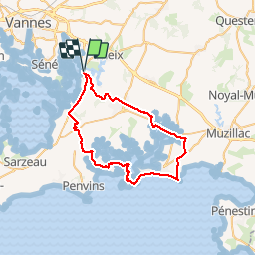
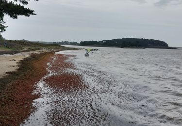
Ruta Bicicleta híbrida de 48 km a descubrir en Bretaña, Morbihan, Theix-Noyalo. Esta ruta ha sido propuesta por ilur56.
Descripción
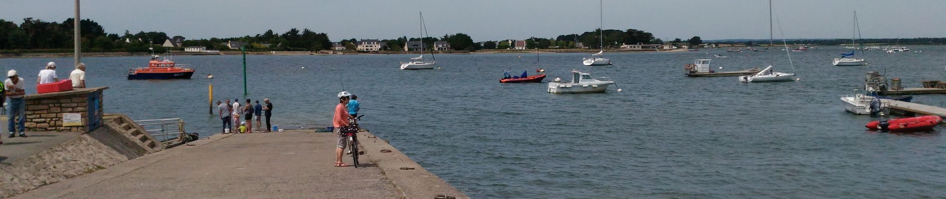
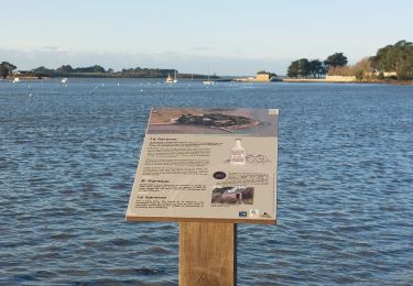
Petits chemins et petites routes. Traversée de la rivière de Pénerf avec le passeur du Lenn. Se renseigner sur les possibilités de passage.
Localización
País:
France
Región :
Bretaña
Departamento/provincia :
Morbihan
Municipio :
Theix-Noyalo
Localidad:
Unknown
Salida:(Dec)
Salida:(UTM)
523832 ; 5273282 (30T) N.
Comentarios
Excursiones cerca
![Excursión Senderismo Saint-Armel - Île TASCON- Le Passage 56 - Photo](https://media.geolcdn.com/t/375/260/ext.jpg?maxdim=2&url=https%3A%2F%2Fstatic1.geolcdn.com%2Fsiteimages%2Fupload%2Ffiles%2F1553511878bg_sport_marche.png)
![Senderismo Senderismo](https://static1.geolcdn.com/sitytour/trail-icons/101.png)
Île TASCON- Le Passage 56
Senderismo
Fácil
(1)
Saint-Armel,
Bretaña,
Morbihan,
France
![](/images/other/stat-length.png)
11,5 km | 12,1 km-effort
2h 31min
![](https://static1.geolcdn.com/siteimages/upload/files/16400158638029165_repeat_loop_refresh_sync_direction_icon.png)
Sí
![Excursión Senderismo Saint-Armel - St Armel en passant par l'Ile de Tason (Boucle) - Photo](https://media.geolcdn.com/t/375/260/ext.jpg?maxdim=2&url=https%3A%2F%2Fstatic1.geolcdn.com%2Fsiteimages%2Fupload%2Ffiles%2F1553511878bg_sport_marche.png)
![Senderismo Senderismo](https://static1.geolcdn.com/sitytour/trail-icons/101.png)
St Armel en passant par l'Ile de Tason (Boucle)
Senderismo
Medio
(3)
Saint-Armel,
Bretaña,
Morbihan,
France
![](/images/other/stat-length.png)
20 km | 22 km-effort
4h 49min
![](https://static1.geolcdn.com/siteimages/upload/files/16400158638029165_repeat_loop_refresh_sync_direction_icon.png)
Sí
![Bici eléctrica Bici eléctrica](https://static1.geolcdn.com/sitytour/trail-icons/205.png)
Boucle De Surzur à Ambon
Bici eléctrica
Medio
Surzur,
Bretaña,
Morbihan,
France
![](/images/other/stat-length.png)
16 km | 17,6 km-effort
1h 15min
![](https://static1.geolcdn.com/siteimages/upload/files/16400158638029165_repeat_loop_refresh_sync_direction_icon.png)
Sí
![Excursión Senderismo Séné - PR_56_Sene_IA_09_Circuit1b_Sentier-Des-Gabelous_20240311 - Photo](https://media.geolcdn.com/t/375/260/c2ea644e-e03f-4409-ac55-71c5dee67584.jpg&format=jpg&maxdim=2)
![Senderismo Senderismo](https://static1.geolcdn.com/sitytour/trail-icons/101.png)
PR_56_Sene_IA_09_Circuit1b_Sentier-Des-Gabelous_20240311
Senderismo
Muy fácil
Séné,
Bretaña,
Morbihan,
France
![](/images/other/stat-length.png)
10,1 km | 11 km-effort
1h 53min
![](https://static1.geolcdn.com/siteimages/upload/files/16400158638029165_repeat_loop_refresh_sync_direction_icon.png)
Sí
![Excursión Senderismo Séné - PR_56_Sene_HA_08_Circuit3a_Du-Passage_20231205 - Photo](https://media.geolcdn.com/t/375/260/d5b7643d-c63d-4161-aaf0-6fe7e6e442e1.jpg&format=jpg&maxdim=2)
![Senderismo Senderismo](https://static1.geolcdn.com/sitytour/trail-icons/101.png)
PR_56_Sene_HA_08_Circuit3a_Du-Passage_20231205
Senderismo
Medio
Séné,
Bretaña,
Morbihan,
France
![](/images/other/stat-length.png)
8,5 km | 9,7 km-effort
1h 47min
![](https://static1.geolcdn.com/siteimages/upload/files/16400158638029165_repeat_loop_refresh_sync_direction_icon.png)
Sí
![Excursión Senderismo Séné - PR_56_Sene_GA_07_Circuit3b_Entre-Bocage-Et-Marais_20231115 - Photo](https://media.geolcdn.com/t/375/260/90de986c-3b14-49b7-b42b-f41416db033a.jpg&format=jpg&maxdim=2)
![Senderismo Senderismo](https://static1.geolcdn.com/sitytour/trail-icons/101.png)
PR_56_Sene_GA_07_Circuit3b_Entre-Bocage-Et-Marais_20231115
Senderismo
Medio
Séné,
Bretaña,
Morbihan,
France
![](/images/other/stat-length.png)
7,8 km | 8,3 km-effort
1h 30min
![](https://static1.geolcdn.com/siteimages/upload/files/16400158638029165_repeat_loop_refresh_sync_direction_icon.png)
Sí
![Excursión Senderismo Theix-Noyalo - PR_56_Theix-Noyalo_AA_01_Circuit3b_Vers-Corn-Er-Hoet_20230401 - Photo](https://media.geolcdn.com/t/375/260/53a27219-59ef-468a-9654-2c8ca963d998.jpg&format=jpg&maxdim=2)
![Senderismo Senderismo](https://static1.geolcdn.com/sitytour/trail-icons/101.png)
PR_56_Theix-Noyalo_AA_01_Circuit3b_Vers-Corn-Er-Hoet_20230401
Senderismo
Medio
Theix-Noyalo,
Bretaña,
Morbihan,
France
![](/images/other/stat-length.png)
8,3 km | 9,9 km-effort
1h 40min
![](https://static1.geolcdn.com/siteimages/upload/files/16400158638029165_repeat_loop_refresh_sync_direction_icon.png)
Sí
![Excursión Senderismo Séné - PR_56_Sene_FA_06_Circuit3b_Le-Bourg-Et-Ses-Rivages_20230206 - Photo](https://media.geolcdn.com/t/375/260/169b12f8-5799-478a-8a15-2ebf012a9c5c.jpg&format=jpg&maxdim=2)
![Senderismo Senderismo](https://static1.geolcdn.com/sitytour/trail-icons/101.png)
PR_56_Sene_FA_06_Circuit3b_Le-Bourg-Et-Ses-Rivages_20230206
Senderismo
Fácil
Séné,
Bretaña,
Morbihan,
France
![](/images/other/stat-length.png)
3,3 km | 3,6 km-effort
43min
![](https://static1.geolcdn.com/siteimages/upload/files/16400158638029165_repeat_loop_refresh_sync_direction_icon.png)
Sí
![Excursión Senderismo Séné - PR_56_Sene_DA_04_Circuit3b_De-La-Pointe-Du-Bill_20221231 - Photo](https://media.geolcdn.com/t/375/260/648f8142-1f31-4e26-9f18-51324015b55d.jpg&format=jpg&maxdim=2)
![Senderismo Senderismo](https://static1.geolcdn.com/sitytour/trail-icons/101.png)
PR_56_Sene_DA_04_Circuit3b_De-La-Pointe-Du-Bill_20221231
Senderismo
Muy fácil
Séné,
Bretaña,
Morbihan,
France
![](/images/other/stat-length.png)
7,3 km | 7,9 km-effort
1h 37min
![](https://static1.geolcdn.com/siteimages/upload/files/16400158638029165_repeat_loop_refresh_sync_direction_icon.png)
Sí