![](/images/other/stat-length.png)
![Excursión Carrera Boeschepe - mont noir - mont kokereel - Photo](https://media.geolcdn.com/t/1900/400/ext.pjpeg?maxdim=2&url=https%3A%2F%2Fstatic1.geolcdn.com%2Fsiteimages%2Fupload%2Ffiles%2F1524743154running.jpg)
mont noir - mont kokereel
jamboxland
Usuario
![Longitud](/images/other/stat-length.png)
Longitud
13,8 km
![Altitud máxima](https://static1.geolcdn.com/siteimages/upload/files/1508320355ic_sort_altitude_max_24dp.png)
Altitud máxima
139 m
![Desnivel positivo](https://static1.geolcdn.com/siteimages/upload/files/1508320355ic_sort_den_pos_24dp.png)
Desnivel positivo
340 m
![Km-Effort](/images/other/stat-length.png)
Km-Effort
18,3 km
![Altitud mínima](https://static1.geolcdn.com/siteimages/upload/files/1508320355ic_sort_altitude_min_24dp.png)
Altitud mínima
37 m
![Desnivel negativo](https://static1.geolcdn.com/siteimages/upload/files/1508320355ic_sort_den_neg_24dp.png)
Desnivel negativo
339 m
![Boucle](https://static1.geolcdn.com/siteimages/upload/files/16400158638029165_repeat_loop_refresh_sync_direction_icon.png)
Boucle
Sí
Fecha de creación :
2014-12-10 00:00:00.0
Última modificación :
2014-12-10 00:00:00.0
![Carrera](https://static1.geolcdn.com/sitytour/trail-icons/103.png)
1h23
Dificultad : Medio
![Escanee este código QR para abrir la excursión en la aplicación SityTrail](https://capi.geolives.com/qq0zvz2zws4bq2lad0pu/sitytour/trails/197077/qr.png?size=200)
Aplicación GPS de excursión GRATIS
A propósito
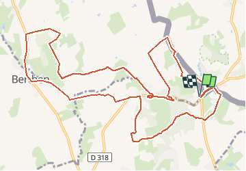
Ruta Carrera de 13,8 km a descubrir en Alta Francia, Norte, Boeschepe. Esta ruta ha sido propuesta por jamboxland.
Descripción
route, chemins agricoles et sous-bois. Boueux en cas de pluie.circuit moins pittoresque que le mont des cats. Attention dernière montée assez dure...
Localización
País:
France
Región :
Alta Francia
Departamento/provincia :
Norte
Municipio :
Boeschepe
Localidad:
Unknown
Salida:(Dec)
Salida:(UTM)
481503 ; 5625424 (31U) N.
Comentarios
Excursiones cerca
![Excursión Senderismo Heuvelland - Loker - Le Mont Rouge - Photo](https://media.geolcdn.com/t/375/260/ext.jpg?maxdim=2&url=https%3A%2F%2Fservices.sitytrail.com%2FGeolivesWS%2FDownloadMedia.ashx%3FTrailID%3D106138%26Media%3D10379_6.jpg)
![Senderismo Senderismo](https://static1.geolcdn.com/sitytour/trail-icons/101.png)
Loker - Le Mont Rouge
Senderismo
Medio
(3)
Heuvelland,
Flandes,
Flandes Occidental,
Belgium
![](/images/other/stat-length.png)
8,7 km | 10,8 km-effort
2h 19min
![](https://static1.geolcdn.com/siteimages/upload/files/16400158638029165_repeat_loop_refresh_sync_direction_icon.png)
Sí
![Excursión A pie Heuvelland - Tweebergen wandelroute - Photo](https://media.geolcdn.com/t/375/260/ext.jpg?maxdim=2&url=https%3A%2F%2Fmedia.geolcdn.com%2Ff%2F5ebabc26-e95b-4a58-8ae1-ac851bf88f60.jpeg)
![A pie A pie](https://static1.geolcdn.com/sitytour/trail-icons/100.png)
Tweebergen wandelroute
A pie
Fácil
Heuvelland,
Flandes,
Flandes Occidental,
Belgium
![](/images/other/stat-length.png)
7,3 km | 9 km-effort
2h 2min
![](https://static1.geolcdn.com/siteimages/upload/files/16400158638029165_repeat_loop_refresh_sync_direction_icon.png)
Sí
![Excursión Senderismo Heuvelland - Westouter langs tweetermen - Photo](https://media.geolcdn.com/t/375/260/ext.jpg?maxdim=2&url=https%3A%2F%2Fstatic1.geolcdn.com%2Fsiteimages%2Fupload%2Ffiles%2F1553511878bg_sport_marche.png)
![Senderismo Senderismo](https://static1.geolcdn.com/sitytour/trail-icons/101.png)
Westouter langs tweetermen
Senderismo
Difícil
(1)
Heuvelland,
Flandes,
Flandes Occidental,
Belgium
![](/images/other/stat-length.png)
7,5 km | 9,1 km-effort
2h 4min
![](https://static1.geolcdn.com/siteimages/upload/files/16400158638029165_repeat_loop_refresh_sync_direction_icon.png)
Sí
![Excursión Motor Bailleul - 104 - Photo](https://media.geolcdn.com/t/375/260/ext.jpg?maxdim=2&url=https%3A%2F%2Fstatic1.geolcdn.com%2Fsiteimages%2Fupload%2Ffiles%2F15247431544x4.jpg)
![Motor Motor](https://static1.geolcdn.com/sitytour/trail-icons/400.png)
![Excursión Senderismo Saint-Jans-Cappel - sentier des jacynthes - Photo](https://media.geolcdn.com/t/375/260/ext.jpg?maxdim=2&url=https%3A%2F%2Fstatic1.geolcdn.com%2Fsiteimages%2Fupload%2Ffiles%2F1553511878bg_sport_marche.png)
![Senderismo Senderismo](https://static1.geolcdn.com/sitytour/trail-icons/101.png)
sentier des jacynthes
Senderismo
Medio
(1)
Saint-Jans-Cappel,
Alta Francia,
Norte,
France
![](/images/other/stat-length.png)
7,3 km | 9,2 km-effort
2h 1min
![](https://static1.geolcdn.com/siteimages/upload/files/16400158638029165_repeat_loop_refresh_sync_direction_icon.png)
Sí
![Excursión Senderismo Bailleul - camping de la Ferme des Saules à côté de Bailleul, arrivée Deulemont - Photo](https://media.geolcdn.com/t/375/260/ext.jpg?maxdim=2&url=https%3A%2F%2Fmedia.geolcdn.com%2Ff%2F5dfd3b71-bc9e-42e1-b3be-5ab9c2cf49ac.jpg)
![Senderismo Senderismo](https://static1.geolcdn.com/sitytour/trail-icons/101.png)
camping de la Ferme des Saules à côté de Bailleul, arrivée Deulemont
Senderismo
Medio
Bailleul,
Alta Francia,
Norte,
France
![](/images/other/stat-length.png)
32 km | 34 km-effort
9h 10min
![](https://static1.geolcdn.com/siteimages/upload/files/16400158638029165_repeat_loop_refresh_sync_direction_icon.png)
No
![Excursión Senderismo Heuvelland - Dranouter 12,3 km - Photo](https://media.geolcdn.com/t/375/260/ext.jpg?maxdim=2&url=https%3A%2F%2Fmedia.geolcdn.com%2Ff%2Fab62849d-d2cc-4c63-a20f-7ad369b5fc0f.jpg)
![Senderismo Senderismo](https://static1.geolcdn.com/sitytour/trail-icons/101.png)
Dranouter 12,3 km
Senderismo
Fácil
Heuvelland,
Flandes,
Flandes Occidental,
Belgium
![](/images/other/stat-length.png)
12,4 km | 14,5 km-effort
3h 32min
![](https://static1.geolcdn.com/siteimages/upload/files/16400158638029165_repeat_loop_refresh_sync_direction_icon.png)
Sí
![Excursión Senderismo Heuvelland - Monts Rouge et Noir - Photo](https://media.geolcdn.com/t/375/260/ext.jpg?maxdim=2&url=https%3A%2F%2Fmedia.geolcdn.com%2Ff%2F00f0cdf9-629e-4b2f-b8bc-5c314a6f710b.jpg)
![Senderismo Senderismo](https://static1.geolcdn.com/sitytour/trail-icons/101.png)
Monts Rouge et Noir
Senderismo
Difícil
Heuvelland,
Flandes,
Flandes Occidental,
Belgium
![](/images/other/stat-length.png)
24 km | 30 km-effort
5h 27min
![](https://static1.geolcdn.com/siteimages/upload/files/16400158638029165_repeat_loop_refresh_sync_direction_icon.png)
Sí
![Excursión Senderismo Boeschepe - Boeschepe - Photo](https://media.geolcdn.com/t/375/260/ext.jpg?maxdim=2&url=https%3A%2F%2Fmedia.geolcdn.com%2Ff%2F6c0906d5-5117-4202-927a-8c802fc11963.jpg)
![Senderismo Senderismo](https://static1.geolcdn.com/sitytour/trail-icons/101.png)
Boeschepe
Senderismo
Difícil
Boeschepe,
Alta Francia,
Norte,
France
![](/images/other/stat-length.png)
10,6 km | 13 km-effort
2h 26min
![](https://static1.geolcdn.com/siteimages/upload/files/16400158638029165_repeat_loop_refresh_sync_direction_icon.png)
No