![](/images/other/stat-length.png)
![Excursión Otra actividad Realp - UR / furkapass - albert-heim-hütte - hospental - tag 2 - Photo](https://media.geolcdn.com/t/1900/400/ext.pjpeg?maxdim=2&url=https%3A%2F%2Fstatic1.geolcdn.com%2Fsiteimages%2Fupload%2Ffiles%2F1545311037marcheuse_200dpi.jpg)
UR / furkapass - albert-heim-hütte - hospental - tag 2
denisewanderige
Usuario
![Longitud](/images/other/stat-length.png)
Longitud
12 km
![Altitud máxima](https://static1.geolcdn.com/siteimages/upload/files/1508320355ic_sort_altitude_max_24dp.png)
Altitud máxima
2534 m
![Desnivel positivo](https://static1.geolcdn.com/siteimages/upload/files/1508320355ic_sort_den_pos_24dp.png)
Desnivel positivo
225 m
![Km-Effort](/images/other/stat-length.png)
Km-Effort
18,5 km
![Altitud mínima](https://static1.geolcdn.com/siteimages/upload/files/1508320355ic_sort_altitude_min_24dp.png)
Altitud mínima
1451 m
![Desnivel negativo](https://static1.geolcdn.com/siteimages/upload/files/1508320355ic_sort_den_neg_24dp.png)
Desnivel negativo
1271 m
![Boucle](https://static1.geolcdn.com/siteimages/upload/files/16400158638029165_repeat_loop_refresh_sync_direction_icon.png)
Boucle
No
Fecha de creación :
2014-12-11 00:00:00.0
Última modificación :
2014-12-11 00:00:00.0
![Otra actividad](https://static1.geolcdn.com/sitytour/trail-icons/900.png)
--
Dificultad : Desconocido
![Escanee este código QR para abrir la excursión en la aplicación SityTrail](https://capi.geolives.com/qq0zvz2zws4bq2lad0pu/sitytour/trails/19433/qr.png?size=200)
Aplicación GPS de excursión GRATIS
A propósito
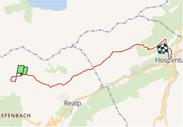
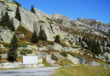
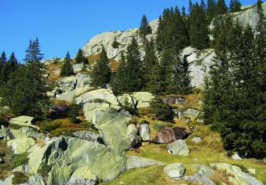
Ruta Otra actividad de 12 km a descubrir en Uri, Korporation Ursern, Realp. Esta ruta ha sido propuesta por denisewanderige.
Descripción
Details (Wanderbeschrieb, Fotos, Dauer, Links, usw.) siehe unter:
http://www.wanderige.ch/wanderige_toure/2003-2005/furka_2/furka_zwei.htm
Localización
País:
Switzerland
Región :
Uri
Departamento/provincia :
Korporation Ursern
Municipio :
Realp
Localidad:
Unknown
Salida:(Dec)
Salida:(UTM)
458916 ; 5161850 (32T) N.
Comentarios
Excursiones cerca
![Excursión A pie Göschenen - Göscheneralp - Horwen - Photo](https://media.geolcdn.com/t/375/260/04f1b544-45a4-4ef2-a888-1baa89638e44.jpeg&format=jpg&maxdim=2)
![A pie A pie](https://static1.geolcdn.com/sitytour/trail-icons/100.png)
Göscheneralp - Horwen
A pie
Fácil
Göschenen,
Uri,
Desconocido,
Switzerland
![](/images/other/stat-length.png)
4,5 km | 6,2 km-effort
1h 23min
![](https://static1.geolcdn.com/siteimages/upload/files/16400158638029165_repeat_loop_refresh_sync_direction_icon.png)
No
![Excursión A pie Göschenen - Göscheneralpsee Rundwanderung - Photo](https://media.geolcdn.com/t/375/260/c35df5ce-11c2-4f07-9212-09dce218f391.jpeg&format=jpg&maxdim=2)
![A pie A pie](https://static1.geolcdn.com/sitytour/trail-icons/100.png)
Göscheneralpsee Rundwanderung
A pie
Fácil
Göschenen,
Uri,
Desconocido,
Switzerland
![](/images/other/stat-length.png)
8,8 km | 14,4 km-effort
3h 16min
![](https://static1.geolcdn.com/siteimages/upload/files/16400158638029165_repeat_loop_refresh_sync_direction_icon.png)
Sí
![Excursión A pie Göschenen - Göscheneralp-Bergsee - Photo](https://media.geolcdn.com/t/375/260/04f1b544-45a4-4ef2-a888-1baa89638e44.jpeg&format=jpg&maxdim=2)
![A pie A pie](https://static1.geolcdn.com/sitytour/trail-icons/100.png)
Göscheneralp-Bergsee
A pie
Fácil
Göschenen,
Uri,
Desconocido,
Switzerland
![](/images/other/stat-length.png)
3,5 km | 9,3 km-effort
2h 6min
![](https://static1.geolcdn.com/siteimages/upload/files/16400158638029165_repeat_loop_refresh_sync_direction_icon.png)
No
![Excursión Senderismo Göschenen - Göscheneralp Tal - Photo](https://media.geolcdn.com/t/375/260/ext.jpg?maxdim=2&url=https%3A%2F%2Fstatic1.geolcdn.com%2Fsiteimages%2Fupload%2Ffiles%2F1553511878bg_sport_marche.png)
![Senderismo Senderismo](https://static1.geolcdn.com/sitytour/trail-icons/101.png)
Göscheneralp Tal
Senderismo
Muy fácil
Göschenen,
Uri,
Desconocido,
Switzerland
![](/images/other/stat-length.png)
18,3 km | 29 km-effort
Desconocido
![](https://static1.geolcdn.com/siteimages/upload/files/16400158638029165_repeat_loop_refresh_sync_direction_icon.png)
No
![Excursión Senderismo Realp - sf_e8c - Photo](https://media.geolcdn.com/t/375/260/ext.jpg?maxdim=2&url=https%3A%2F%2Fstatic1.geolcdn.com%2Fsiteimages%2Fupload%2Ffiles%2F1553511878bg_sport_marche.png)
![Senderismo Senderismo](https://static1.geolcdn.com/sitytour/trail-icons/101.png)
sf_e8c
Senderismo
Muy fácil
Realp,
Uri,
Korporation Ursern,
Switzerland
![](/images/other/stat-length.png)
23 km | 39 km-effort
6h 52min
![](https://static1.geolcdn.com/siteimages/upload/files/16400158638029165_repeat_loop_refresh_sync_direction_icon.png)
No
![Excursión Senderismo Realp - sf_e8b - Photo](https://media.geolcdn.com/t/375/260/ext.jpg?maxdim=2&url=https%3A%2F%2Fstatic1.geolcdn.com%2Fsiteimages%2Fupload%2Ffiles%2F1553511878bg_sport_marche.png)
![Senderismo Senderismo](https://static1.geolcdn.com/sitytour/trail-icons/101.png)
sf_e8b
Senderismo
Muy fácil
Realp,
Uri,
Korporation Ursern,
Switzerland
![](/images/other/stat-length.png)
11,2 km | 21 km-effort
3h 36min
![](https://static1.geolcdn.com/siteimages/upload/files/16400158638029165_repeat_loop_refresh_sync_direction_icon.png)
Sí
![Excursión Senderismo Göschenen - sf_e7b - Photo](https://media.geolcdn.com/t/375/260/ext.jpg?maxdim=2&url=https%3A%2F%2Fstatic1.geolcdn.com%2Fsiteimages%2Fupload%2Ffiles%2F1553511878bg_sport_marche.png)
![Senderismo Senderismo](https://static1.geolcdn.com/sitytour/trail-icons/101.png)
sf_e7b
Senderismo
Muy fácil
Göschenen,
Uri,
Desconocido,
Switzerland
![](/images/other/stat-length.png)
12,6 km | 22 km-effort
3h 50min
![](https://static1.geolcdn.com/siteimages/upload/files/16400158638029165_repeat_loop_refresh_sync_direction_icon.png)
No
![Excursión Senderismo Realp - Realp - Tiefenbach 2012 - Photo](https://media.geolcdn.com/t/375/260/ext.jpg?maxdim=2&url=https%3A%2F%2Fservices.sitytrail.com%2FGeolivesWS%2FDownloadMedia.ashx%3FTrailID%3D167551%26Media%3D20121228163432.jpg)
![Senderismo Senderismo](https://static1.geolcdn.com/sitytour/trail-icons/101.png)
Realp - Tiefenbach 2012
Senderismo
Muy fácil
Realp,
Uri,
Korporation Ursern,
Switzerland
![](/images/other/stat-length.png)
5,3 km | 11,4 km-effort
3h 6min
![](https://static1.geolcdn.com/siteimages/upload/files/16400158638029165_repeat_loop_refresh_sync_direction_icon.png)
No
![Excursión Otra actividad Göschenen - Chelenalp - Photo](https://media.geolcdn.com/t/375/260/ext.jpg?maxdim=2&url=https%3A%2F%2Fstatic1.geolcdn.com%2Fsiteimages%2Fupload%2Ffiles%2F1545311037marcheuse_200dpi.jpg)
![Otra actividad Otra actividad](https://static1.geolcdn.com/sitytour/trail-icons/900.png)
Chelenalp
Otra actividad
Muy fácil
Göschenen,
Uri,
Desconocido,
Switzerland
![](/images/other/stat-length.png)
13,6 km | 29 km-effort
Desconocido
![](https://static1.geolcdn.com/siteimages/upload/files/16400158638029165_repeat_loop_refresh_sync_direction_icon.png)
Sí