![](/images/other/stat-length.png)
![Excursión Senderismo Ribeauvillé - Taennschel depuis Ribeauvillé - Photo](https://media.geolcdn.com/t/1900/400/ext.pjpeg?maxdim=2&url=https%3A%2F%2Fstatic1.geolcdn.com%2Fsiteimages%2Fupload%2Ffiles%2F1553511878bg_sport_marche.png)
Taennschel depuis Ribeauvillé
Fourmis.nf
Usuario
![Longitud](/images/other/stat-length.png)
![Altitud máxima](https://static1.geolcdn.com/siteimages/upload/files/1508320355ic_sort_altitude_max_24dp.png)
![Desnivel positivo](https://static1.geolcdn.com/siteimages/upload/files/1508320355ic_sort_den_pos_24dp.png)
![Km-Effort](/images/other/stat-length.png)
![Altitud mínima](https://static1.geolcdn.com/siteimages/upload/files/1508320355ic_sort_altitude_min_24dp.png)
![Desnivel negativo](https://static1.geolcdn.com/siteimages/upload/files/1508320355ic_sort_den_neg_24dp.png)
![Boucle](https://static1.geolcdn.com/siteimages/upload/files/16400158638029165_repeat_loop_refresh_sync_direction_icon.png)
![Senderismo](https://static1.geolcdn.com/sitytour/trail-icons/101.png)
5h59
Dificultad : Medio
![Escanee este código QR para abrir la excursión en la aplicación SityTrail](https://capi.geolives.com/qq0zvz2zws4bq2lad0pu/sitytour/trails/193098/qr.png?size=200)
Aplicación GPS de excursión GRATIS
A propósito
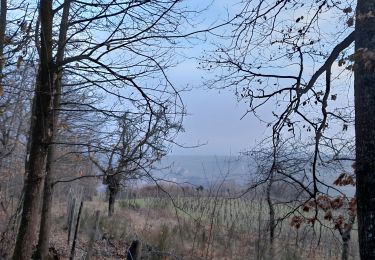
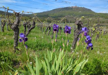
Ruta Senderismo de 17,4 km a descubrir en Gran Este, Alto Rin, Ribeauvillé. Esta ruta ha sido propuesta por Fourmis.nf.
Descripción
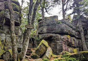
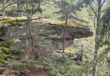
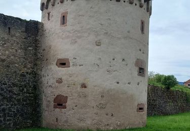
Randonnée Pentecôte : le Taennschel depuis les châteaux de Ribeauvillé :
Départ depuis le parking Lutzekbach après l''hôpital. Suivre balisage GR5 rectangle rouge direction les ruines de St Ulrich (la visité vaut le détour). Poursuivre vers le château de Ribaupierre (non accessible). Le balisage rectangle rouge/blanc/rouge en direction du carrefour du cerisier noir. Prendre le sentier gauche pour rejoindre le carrefour Hasenclever et son refuge. Le sentier forestier à gauche, rectangle jaune/blanc/jaune direction "verriere" 45mn pour rejoindre un petit sentier qui monte sûr le droite, croix bleue vers Rammelfels. Attention deux sentiers se succèdent, ne pas prendre le premier. Prendre à gauche jusqu''au "Trois tables". Retour sûr nos pas, suivre balise jaune/blanc/jaune pour découvrir l''ambiance particulière des roches du Taennschel : reptiles, géants, belle vue, titans, de la garde, la pointe. Depuis la roche de la paix d'Udine, redescendre vers le carrefour Hasenclever, rectangle rouge/blanc/rouge. Poursuivre vers le cerisier noir à partir duquel on prendra un sentier qui descend à droite, triangle bleu, vers le monastère ND Dusenbach. Pour le retour au parking, je vous laisse decouvrir...
Localización
Comentarios
Excursiones cerca
![Excursión Bici de montaña Ribeauvillé - Ribeauvillé Riquewihr - Photo](https://media.geolcdn.com/t/375/260/ext.jpg?maxdim=2&url=https%3A%2F%2Fservices.sitytrail.com%2FGeolivesWS%2FDownloadMedia.ashx%3FTrailID%3D101224%26Media%3D712_1.jpg)
![Bici de montaña Bici de montaña](https://static1.geolcdn.com/sitytour/trail-icons/202.png)
Bici de montaña
![](/images/other/stat-length.png)
![](https://static1.geolcdn.com/siteimages/upload/files/16400158638029165_repeat_loop_refresh_sync_direction_icon.png)
![Excursión Senderismo Ribeauvillé - 2023-08-26 Marche Ribeauville Taennchel - Photo](https://media.geolcdn.com/t/375/260/74d8ac69-de70-4d04-a080-288de3ed9a04.jpg&format=jpg&maxdim=2)
![Senderismo Senderismo](https://static1.geolcdn.com/sitytour/trail-icons/101.png)
Senderismo
![](/images/other/stat-length.png)
![](https://static1.geolcdn.com/siteimages/upload/files/16400158638029165_repeat_loop_refresh_sync_direction_icon.png)
![Excursión Senderismo Hunawihr - Hunawihr - Riquewihr - Photo](https://media.geolcdn.com/t/375/260/ext.jpg?maxdim=2&url=https%3A%2F%2Fstatic1.geolcdn.com%2Fsiteimages%2Fupload%2Ffiles%2F1553511878bg_sport_marche.png)
![Senderismo Senderismo](https://static1.geolcdn.com/sitytour/trail-icons/101.png)
Senderismo
![](/images/other/stat-length.png)
![](https://static1.geolcdn.com/siteimages/upload/files/16400158638029165_repeat_loop_refresh_sync_direction_icon.png)
![Excursión Senderismo Riquewihr - Sentier des grands crus - Photo](https://media.geolcdn.com/t/375/260/ext.jpg?maxdim=2&url=https%3A%2F%2Fservices.sitytrail.com%2FGeolivesWS%2FDownloadMedia.ashx%3FTrailID%3D482185%26Media%3D8532cb29-bcf9-4719-bd1f-5f2e4165e237.jpg)
![Senderismo Senderismo](https://static1.geolcdn.com/sitytour/trail-icons/101.png)
Senderismo
![](/images/other/stat-length.png)
![](https://static1.geolcdn.com/siteimages/upload/files/16400158638029165_repeat_loop_refresh_sync_direction_icon.png)
![Excursión Senderismo Saint-Hippolyte - St hippolyte ht koenigsbourg - Photo](https://media.geolcdn.com/t/375/260/ext.jpg?maxdim=2&url=https%3A%2F%2Fstatic1.geolcdn.com%2Fsiteimages%2Fupload%2Ffiles%2F1553511878bg_sport_marche.png)
![Senderismo Senderismo](https://static1.geolcdn.com/sitytour/trail-icons/101.png)
Senderismo
![](/images/other/stat-length.png)
![](https://static1.geolcdn.com/siteimages/upload/files/16400158638029165_repeat_loop_refresh_sync_direction_icon.png)
![Excursión Senderismo Hunawihr - Hunawihr 2025-01 - Photo](https://media.geolcdn.com/t/375/260/b6bd9225-093a-48dc-8f70-42791125d53f.jpg&format=jpg&maxdim=2)
![Senderismo Senderismo](https://static1.geolcdn.com/sitytour/trail-icons/101.png)
Senderismo
![](/images/other/stat-length.png)
![](https://static1.geolcdn.com/siteimages/upload/files/16400158638029165_repeat_loop_refresh_sync_direction_icon.png)
![Excursión sport Ribeauvillé - Grande verrerie - Rocher des Géants - Photo](https://media.geolcdn.com/t/375/260/30248580-5737-46ba-92f8-71cb1fb9f570.jpg&format=jpg&maxdim=2)
sport
![](/images/other/stat-length.png)
![](https://static1.geolcdn.com/siteimages/upload/files/16400158638029165_repeat_loop_refresh_sync_direction_icon.png)
![Excursión Senderismo Bergheim - Berghien - Photo](https://media.geolcdn.com/t/375/260/9521df30-806f-464d-a648-d6cec2b043b6.jpg&format=jpg&maxdim=2)
![Senderismo Senderismo](https://static1.geolcdn.com/sitytour/trail-icons/101.png)
Senderismo
![](/images/other/stat-length.png)
![](https://static1.geolcdn.com/siteimages/upload/files/16400158638029165_repeat_loop_refresh_sync_direction_icon.png)
![Excursión Senderismo Saint-Hippolyte - St-Hippolyte - Rorschwihr - Grasberg - Bergheim - Reichenberg - Rodern - Photo](https://media.geolcdn.com/t/375/260/44aae6a9-c2ff-44af-afea-23b4ed406441.jpg&format=jpg&maxdim=2)
![Senderismo Senderismo](https://static1.geolcdn.com/sitytour/trail-icons/101.png)
Senderismo
![](/images/other/stat-length.png)
![](https://static1.geolcdn.com/siteimages/upload/files/16400158638029165_repeat_loop_refresh_sync_direction_icon.png)