![](/images/other/stat-length.png)
![Excursión Senderismo Botsorhel - Sentiers buissonniers à Botsorhel - Photo](https://media.geolcdn.com/t/1900/400/ext.pjpeg?maxdim=2&url=https%3A%2F%2Fservices.sitytrail.com%2FGeolivesWS%2FDownloadMedia.ashx%3FTrailID%3D191648%26Media%3D15299_6.jpg)
Sentiers buissonniers à Botsorhel
tracegps
Usuario
![Longitud](/images/other/stat-length.png)
Longitud
14,2 km
![Altitud máxima](https://static1.geolcdn.com/siteimages/upload/files/1508320355ic_sort_altitude_max_24dp.png)
Altitud máxima
218 m
![Desnivel positivo](https://static1.geolcdn.com/siteimages/upload/files/1508320355ic_sort_den_pos_24dp.png)
Desnivel positivo
323 m
![Km-Effort](/images/other/stat-length.png)
Km-Effort
18,5 km
![Altitud mínima](https://static1.geolcdn.com/siteimages/upload/files/1508320355ic_sort_altitude_min_24dp.png)
Altitud mínima
124 m
![Desnivel negativo](https://static1.geolcdn.com/siteimages/upload/files/1508320355ic_sort_den_neg_24dp.png)
Desnivel negativo
323 m
![Boucle](https://static1.geolcdn.com/siteimages/upload/files/16400158638029165_repeat_loop_refresh_sync_direction_icon.png)
Boucle
Sí
Fecha de creación :
2014-12-10 00:00:00.0
Última modificación :
2014-12-10 00:00:00.0
![Senderismo](https://static1.geolcdn.com/sitytour/trail-icons/101.png)
4h30
Dificultad : Difícil
![Escanee este código QR para abrir la excursión en la aplicación SityTrail](https://capi.geolives.com/qq0zvz2zws4bq2lad0pu/sitytour/trails/191648/qr.png?size=200)
Aplicación GPS de excursión GRATIS
A propósito
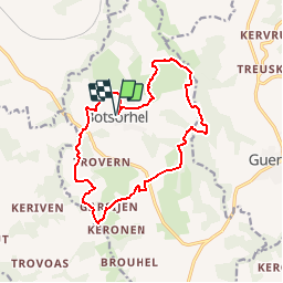
Ruta Senderismo de 14,2 km a descubrir en Bretaña, Finisterre, Botsorhel. Esta ruta ha sido propuesta por tracegps.
Descripción
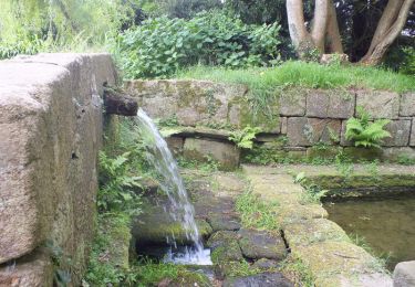
Départ de l'église Saint-Georges de Botsorhel. Le circuit emprunte des sentiers dans un terrain bosselé et verdoyant. Il passe à proximité du château de Keraël et des ruines d'un moulin.
Localización
País:
France
Región :
Bretaña
Departamento/provincia :
Finisterre
Municipio :
Botsorhel
Localidad:
Unknown
Salida:(Dec)
Salida:(UTM)
452621 ; 5375030 (30U) N.
Comentarios
Excursiones cerca
![Excursión A pie Guerlesquin - L'Étang du Guic - Photo](https://media.geolcdn.com/t/375/260/e37d09e2-5e71-44c7-8599-762e549e8bd0.jpeg&format=jpg&maxdim=2)
![A pie A pie](https://static1.geolcdn.com/sitytour/trail-icons/100.png)
L'Étang du Guic
A pie
Medio
Guerlesquin,
Bretaña,
Finisterre,
France
![](/images/other/stat-length.png)
15,9 km | 20 km-effort
4h 33min
![](https://static1.geolcdn.com/siteimages/upload/files/16400158638029165_repeat_loop_refresh_sync_direction_icon.png)
Sí
![Excursión Senderismo Lannéanou - Tour de Lannéanou - Photo](https://media.geolcdn.com/t/375/260/ext.jpg?maxdim=2&url=https%3A%2F%2Fservices.sitytrail.com%2FGeolivesWS%2FDownloadMedia.ashx%3FTrailID%3D316914%26Media%3D16013_3.jpg)
![Senderismo Senderismo](https://static1.geolcdn.com/sitytour/trail-icons/101.png)
Tour de Lannéanou
Senderismo
Difícil
Lannéanou,
Bretaña,
Finisterre,
France
![](/images/other/stat-length.png)
14,8 km | 18,8 km-effort
3h 40min
![](https://static1.geolcdn.com/siteimages/upload/files/16400158638029165_repeat_loop_refresh_sync_direction_icon.png)
Sí
![Excursión A pie Botsorhel - Botshorel Morlaix - Photo](https://media.geolcdn.com/t/375/260/ext.jpg?maxdim=2&url=https%3A%2F%2Fstatic1.geolcdn.com%2Fsiteimages%2Fupload%2Ffiles%2F1545311037marcheuse_200dpi.jpg)
![A pie A pie](https://static1.geolcdn.com/sitytour/trail-icons/100.png)
Botshorel Morlaix
A pie
Difícil
Botsorhel,
Bretaña,
Finisterre,
France
![](/images/other/stat-length.png)
29 km | 35 km-effort
8h 3min
![](https://static1.geolcdn.com/siteimages/upload/files/16400158638029165_repeat_loop_refresh_sync_direction_icon.png)
No
![Excursión A pie Botsorhel - 2022-04-02_21h02m45_SityTrail - 3150665 - et5xbotsorhelxmorlaix - Photo](https://media.geolcdn.com/t/375/260/ext.jpg?maxdim=2&url=https%3A%2F%2Fstatic1.geolcdn.com%2Fsiteimages%2Fupload%2Ffiles%2F1545311037marcheuse_200dpi.jpg)
![A pie A pie](https://static1.geolcdn.com/sitytour/trail-icons/100.png)
2022-04-02_21h02m45_SityTrail - 3150665 - et5xbotsorhelxmorlaix
A pie
Difícil
Botsorhel,
Bretaña,
Finisterre,
France
![](/images/other/stat-length.png)
30 km | 36 km-effort
8h 10min
![](https://static1.geolcdn.com/siteimages/upload/files/16400158638029165_repeat_loop_refresh_sync_direction_icon.png)
No
![Excursión Senderismo Plouégat-Moysan - Ménez Meur - Plouégat - Photo](https://media.geolcdn.com/t/375/260/ext.jpg?maxdim=2&url=https%3A%2F%2Fservices.sitytrail.com%2FGeolivesWS%2FDownloadMedia.ashx%3FTrailID%3D172440%26Media%3D13788_1.jpg)
![Senderismo Senderismo](https://static1.geolcdn.com/sitytour/trail-icons/101.png)
Ménez Meur - Plouégat
Senderismo
Medio
Plouégat-Moysan,
Bretaña,
Finisterre,
France
![](/images/other/stat-length.png)
12,2 km | 15,2 km-effort
3h 30min
![](https://static1.geolcdn.com/siteimages/upload/files/16400158638029165_repeat_loop_refresh_sync_direction_icon.png)
Sí
![Excursión Senderismo Botsorhel - 29_Botsorhel - Photo](https://media.geolcdn.com/t/375/260/ext.jpg?maxdim=2&url=https%3A%2F%2Fstatic1.geolcdn.com%2Fsiteimages%2Fupload%2Ffiles%2F1553511878bg_sport_marche.png)
![Senderismo Senderismo](https://static1.geolcdn.com/sitytour/trail-icons/101.png)
29_Botsorhel
Senderismo
Medio
Botsorhel,
Bretaña,
Finisterre,
France
![](/images/other/stat-length.png)
14,3 km | 18,6 km-effort
3h 22min
![](https://static1.geolcdn.com/siteimages/upload/files/16400158638029165_repeat_loop_refresh_sync_direction_icon.png)
Sí
![Excursión Senderismo Plouigneau - le ponthou - Photo](https://media.geolcdn.com/t/375/260/ext.jpg?maxdim=2&url=https%3A%2F%2Fstatic1.geolcdn.com%2Fsiteimages%2Fupload%2Ffiles%2F1553511878bg_sport_marche.png)
![Senderismo Senderismo](https://static1.geolcdn.com/sitytour/trail-icons/101.png)
le ponthou
Senderismo
Muy fácil
Plouigneau,
Bretaña,
Finisterre,
France
![](/images/other/stat-length.png)
7,6 km | 9,3 km-effort
2h 31min
![](https://static1.geolcdn.com/siteimages/upload/files/16400158638029165_repeat_loop_refresh_sync_direction_icon.png)
No
![Excursión Senderismo Plouigneau - bourouguel broheon la boissiere etc... - Photo](https://media.geolcdn.com/t/375/260/ext.jpg?maxdim=2&url=https%3A%2F%2Fservices.sitytrail.com%2FGeolivesWS%2FDownloadMedia.ashx%3FTrailID%3D222651%26Media%3D20130922153632.jpg)
![Senderismo Senderismo](https://static1.geolcdn.com/sitytour/trail-icons/101.png)
bourouguel broheon la boissiere etc...
Senderismo
Muy fácil
Plouigneau,
Bretaña,
Finisterre,
France
![](/images/other/stat-length.png)
5,7 km | 6,8 km-effort
1h 51min
![](https://static1.geolcdn.com/siteimages/upload/files/16400158638029165_repeat_loop_refresh_sync_direction_icon.png)
Sí
![Excursión Bicicleta Plouigneau - velo bourouguel kermadeen++ - Photo](https://media.geolcdn.com/t/375/260/ext.jpg?maxdim=2&url=https%3A%2F%2Fstatic1.geolcdn.com%2Fsiteimages%2Fupload%2Ffiles%2F1524743154velo.jpg)
![Bicicleta Bicicleta](https://static1.geolcdn.com/sitytour/trail-icons/200.png)
velo bourouguel kermadeen++
Bicicleta
Muy fácil
Plouigneau,
Bretaña,
Finisterre,
France
![](/images/other/stat-length.png)
5 km | 5,8 km-effort
38min
![](https://static1.geolcdn.com/siteimages/upload/files/16400158638029165_repeat_loop_refresh_sync_direction_icon.png)
Sí
tour de botsorhel