![](/images/other/stat-length.png)
![Excursión Senderismo Mandelieu-la-Napoule - L'Estérel via les monts Pelet et Martin - Mandelieu la Napoule - Photo](https://media.geolcdn.com/t/1900/400/ext.pjpeg?maxdim=2&url=https%3A%2F%2Fservices.sitytrail.com%2FGeolivesWS%2FDownloadMedia.ashx%3FTrailID%3D191571%26Media%3D15192_2.jpg)
L'Estérel via les monts Pelet et Martin - Mandelieu la Napoule
tracegps
Usuario
![Longitud](/images/other/stat-length.png)
Longitud
13,9 km
![Altitud máxima](https://static1.geolcdn.com/siteimages/upload/files/1508320355ic_sort_altitude_max_24dp.png)
Altitud máxima
414 m
![Desnivel positivo](https://static1.geolcdn.com/siteimages/upload/files/1508320355ic_sort_den_pos_24dp.png)
Desnivel positivo
586 m
![Km-Effort](/images/other/stat-length.png)
Km-Effort
22 km
![Altitud mínima](https://static1.geolcdn.com/siteimages/upload/files/1508320355ic_sort_altitude_min_24dp.png)
Altitud mínima
16 m
![Desnivel negativo](https://static1.geolcdn.com/siteimages/upload/files/1508320355ic_sort_den_neg_24dp.png)
Desnivel negativo
586 m
![Boucle](https://static1.geolcdn.com/siteimages/upload/files/16400158638029165_repeat_loop_refresh_sync_direction_icon.png)
Boucle
Sí
Fecha de creación :
2014-12-10 00:00:00.0
Última modificación :
2014-12-10 00:00:00.0
![Senderismo](https://static1.geolcdn.com/sitytour/trail-icons/101.png)
4h00
Dificultad : Medio
![Escanee este código QR para abrir la excursión en la aplicación SityTrail](https://capi.geolives.com/qq0zvz2zws4bq2lad0pu/sitytour/trails/191571/qr.png?size=200)
Aplicación GPS de excursión GRATIS
A propósito
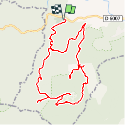
Ruta Senderismo de 13,9 km a descubrir en Provenza-Alpes-Costa Azul, Alpes Marítimos, Mandelieu-la-Napoule. Esta ruta ha sido propuesta por tracegps.
Descripción
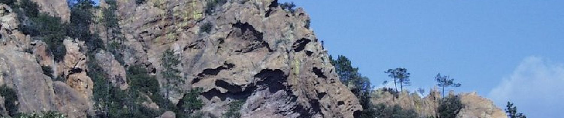
Randonnée au départ du cimetière. 14 km pour un dénivelé de 700 m. Très beau panorama (à ne pas manquer) au sommet du mont Pelet (439m).
Localización
País:
France
Región :
Provenza-Alpes-Costa Azul
Departamento/provincia :
Alpes Marítimos
Municipio :
Mandelieu-la-Napoule
Localidad:
Unknown
Salida:(Dec)
Salida:(UTM)
330474 ; 4821225 (32T) N.
Comentarios
Excursiones cerca
![Excursión Senderismo Mandelieu-la-Napoule - Mont Saint Martin - Photo](https://media.geolcdn.com/t/375/260/ext.jpg?maxdim=2&url=https%3A%2F%2Fservices.sitytrail.com%2FGeolivesWS%2FDownloadMedia.ashx%3FTrailID%3D203071%26Media%3Dfix__20130706124443.jpg)
![Senderismo Senderismo](https://static1.geolcdn.com/sitytour/trail-icons/101.png)
Mont Saint Martin
Senderismo
Fácil
(1)
Mandelieu-la-Napoule,
Provenza-Alpes-Costa Azul,
Alpes Marítimos,
France
![](/images/other/stat-length.png)
9 km | 14,2 km-effort
3h 0min
![](https://static1.geolcdn.com/siteimages/upload/files/16400158638029165_repeat_loop_refresh_sync_direction_icon.png)
Sí
![Excursión Senderismo Saint-Raphaël - SityTrail - ND - Aiguille - Photo](https://media.geolcdn.com/t/375/260/ext.jpg?maxdim=2&url=https%3A%2F%2Fstatic1.geolcdn.com%2Fsiteimages%2Fupload%2Ffiles%2F1553511878bg_sport_marche.png)
![Senderismo Senderismo](https://static1.geolcdn.com/sitytour/trail-icons/101.png)
SityTrail - ND - Aiguille
Senderismo
Muy difícil
(1)
Saint-Raphaël,
Provenza-Alpes-Costa Azul,
Var,
France
![](/images/other/stat-length.png)
18,1 km | 29 km-effort
6h 40min
![](https://static1.geolcdn.com/siteimages/upload/files/16400158638029165_repeat_loop_refresh_sync_direction_icon.png)
Sí
![Excursión A pie Théoule-sur-Mer - Tracé Rocher des Monges par col de Théoule - Photo](https://media.geolcdn.com/t/375/260/ext.jpg?maxdim=2&url=https%3A%2F%2Fstatic1.geolcdn.com%2Fsiteimages%2Fupload%2Ffiles%2F1545311037marcheuse_200dpi.jpg)
![A pie A pie](https://static1.geolcdn.com/sitytour/trail-icons/100.png)
Tracé Rocher des Monges par col de Théoule
A pie
Muy fácil
(1)
Théoule-sur-Mer,
Provenza-Alpes-Costa Azul,
Alpes Marítimos,
France
![](/images/other/stat-length.png)
7,2 km | 11,2 km-effort
Desconocido
![](https://static1.geolcdn.com/siteimages/upload/files/16400158638029165_repeat_loop_refresh_sync_direction_icon.png)
Sí
![Excursión Senderismo Théoule-sur-Mer - Théoule-sur-mer - Grosses Grues - Photo](https://media.geolcdn.com/t/375/260/ext.jpg?maxdim=2&url=https%3A%2F%2Fservices.sitytrail.com%2FGeolivesWS%2FDownloadMedia.ashx%3FTrailID%3D435398%26Media%3Dfix__20150608121929.jpg)
![Senderismo Senderismo](https://static1.geolcdn.com/sitytour/trail-icons/101.png)
Théoule-sur-mer - Grosses Grues
Senderismo
Medio
Théoule-sur-Mer,
Provenza-Alpes-Costa Azul,
Alpes Marítimos,
France
![](/images/other/stat-length.png)
14,7 km | 23 km-effort
4h 30min
![](https://static1.geolcdn.com/siteimages/upload/files/16400158638029165_repeat_loop_refresh_sync_direction_icon.png)
Sí
![Excursión Senderismo Mandelieu-la-Napoule - Grand Duc Alternatif - Photo](https://media.geolcdn.com/t/375/260/ext.jpg?maxdim=2&url=https%3A%2F%2Fstatic1.geolcdn.com%2Fsiteimages%2Fupload%2Ffiles%2F1553511878bg_sport_marche.png)
![Senderismo Senderismo](https://static1.geolcdn.com/sitytour/trail-icons/101.png)
Grand Duc Alternatif
Senderismo
Muy fácil
(1)
Mandelieu-la-Napoule,
Provenza-Alpes-Costa Azul,
Alpes Marítimos,
France
![](/images/other/stat-length.png)
6,4 km | 9,1 km-effort
2h 0min
![](https://static1.geolcdn.com/siteimages/upload/files/16400158638029165_repeat_loop_refresh_sync_direction_icon.png)
Sí
![Excursión Senderismo Mandelieu-la-Napoule -](https://media.geolcdn.com/t/375/260/b86348bf-abb5-455a-82e4-681ad648fdf1.jpg&format=jpg&maxdim=2)
![Senderismo Senderismo](https://static1.geolcdn.com/sitytour/trail-icons/101.png)
"Les oeufs de bouc"
Senderismo
Medio
Mandelieu-la-Napoule,
Provenza-Alpes-Costa Azul,
Alpes Marítimos,
France
![](/images/other/stat-length.png)
14,5 km | 22 km-effort
6h 42min
![](https://static1.geolcdn.com/siteimages/upload/files/16400158638029165_repeat_loop_refresh_sync_direction_icon.png)
Sí
![Excursión Senderismo Mandelieu-la-Napoule - Grand Duc - Photo](https://media.geolcdn.com/t/375/260/bb4952b6-32f3-40dd-b274-07cfc3d80de4.jpg&format=jpg&maxdim=2)
![Senderismo Senderismo](https://static1.geolcdn.com/sitytour/trail-icons/101.png)
Grand Duc
Senderismo
Medio
Mandelieu-la-Napoule,
Provenza-Alpes-Costa Azul,
Alpes Marítimos,
France
![](/images/other/stat-length.png)
8,9 km | 12,5 km-effort
2h 47min
![](https://static1.geolcdn.com/siteimages/upload/files/16400158638029165_repeat_loop_refresh_sync_direction_icon.png)
Sí
![Excursión Senderismo Mandelieu-la-Napoule - châteaux de la Napoule - Photo](https://media.geolcdn.com/t/375/260/0390d912-0cc3-4a3a-a76c-b7a4f5d42e4b.jpg&format=jpg&maxdim=2)
![Senderismo Senderismo](https://static1.geolcdn.com/sitytour/trail-icons/101.png)
châteaux de la Napoule
Senderismo
Fácil
Mandelieu-la-Napoule,
Provenza-Alpes-Costa Azul,
Alpes Marítimos,
France
![](/images/other/stat-length.png)
5,6 km | 7,8 km-effort
2h 23min
![](https://static1.geolcdn.com/siteimages/upload/files/16400158638029165_repeat_loop_refresh_sync_direction_icon.png)
Sí
![Senderismo Senderismo](https://static1.geolcdn.com/sitytour/trail-icons/101.png)
Théoule - Col de Théoule - ND d'Afrique - Pointe de L'Aiguille
Senderismo
Fácil
Théoule-sur-Mer,
Provenza-Alpes-Costa Azul,
Alpes Marítimos,
France
![](/images/other/stat-length.png)
9,9 km | 14,9 km-effort
3h 23min
![](https://static1.geolcdn.com/siteimages/upload/files/16400158638029165_repeat_loop_refresh_sync_direction_icon.png)
Sí