![](/images/other/stat-length.png)
![Excursión Senderismo Vireux-Molhain - Le Camp Romain du Mont Vireux - Photo](https://media.geolcdn.com/t/1900/400/ext.pjpeg?maxdim=2&url=https%3A%2F%2Fservices.sitytrail.com%2FGeolivesWS%2FDownloadMedia.ashx%3FTrailID%3D191467%26Media%3D15059_5.jpg)
Le Camp Romain du Mont Vireux
tracegps
Usuario
![Longitud](/images/other/stat-length.png)
![Altitud máxima](https://static1.geolcdn.com/siteimages/upload/files/1508320355ic_sort_altitude_max_24dp.png)
![Desnivel positivo](https://static1.geolcdn.com/siteimages/upload/files/1508320355ic_sort_den_pos_24dp.png)
![Km-Effort](/images/other/stat-length.png)
![Altitud mínima](https://static1.geolcdn.com/siteimages/upload/files/1508320355ic_sort_altitude_min_24dp.png)
![Desnivel negativo](https://static1.geolcdn.com/siteimages/upload/files/1508320355ic_sort_den_neg_24dp.png)
![Boucle](https://static1.geolcdn.com/siteimages/upload/files/16400158638029165_repeat_loop_refresh_sync_direction_icon.png)
![Senderismo](https://static1.geolcdn.com/sitytour/trail-icons/101.png)
1h00
Dificultad : Fácil
![Escanee este código QR para abrir la excursión en la aplicación SityTrail](https://capi.geolives.com/qq0zvz2zws4bq2lad0pu/sitytour/trails/191467/qr.png?size=200)
Aplicación GPS de excursión GRATIS
A propósito
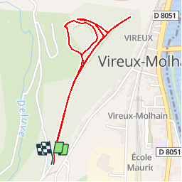
Ruta Senderismo de 2,3 km a descubrir en Gran Este, Ardenas, Vireux-Molhain. Esta ruta ha sido propuesta por tracegps.
Descripción
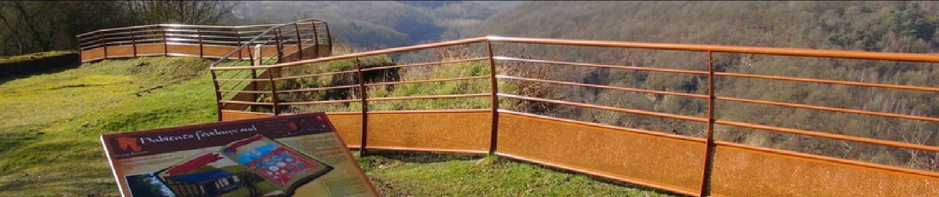
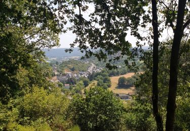
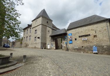
A la confluence de deux vallées, le Viroin et la Meuse, Vireux-Molhain a toujours occupé une place stratégique pour le contrôle militaire de la région. Dès le IIIe siècle, les romains implantent un camp militaire sur les hauteurs de Molhain, au bord de cet éperon rocheux dominant la vallée. Le site de la fortification de hauteur a récemment fait l'objet d'un réaménagement complet en vue d'une plus grande accessibilité et d'une meilleure lisibilité pour le public. Les travaux ont été menés à l'initiative et avec le financement de la communauté de communes "Ardennes Rives de Meuse". De cette ancienne fortification, défendue sur ses quatre côtés par un mur épais, restent visibles les deux tours d'angle de l'enceinte, un four à pain, un foyer circulaire et un cimetière. De nombreux vestiges médiévaux sont également encore visibles. Sur le Mont Vireux , empruntez les traces des légionnaires qui défendaient la Gaule Romaine contre les premières invasions germaniques au IIIe siècle. Sur les lieux vous découvrirez un parfait tableau où se mélange patrimoine et nature. Autres point d'intérêt : le point de vue dominant la vallée de la Meuse et celle du Viroin. ® Départ : Rue Mont Vireux (parking).
Localización
Comentarios
Excursiones cerca
![Excursión Senderismo Viroinval - RB-Na-12 Ed4 Balade franco-belge chez Toine Culot - Photo](https://media.geolcdn.com/t/375/260/ext.jpg?maxdim=2&url=https%3A%2F%2Fservices.sitytrail.com%2FGeolivesWS%2FDownloadMedia.ashx%3FTrailID%3D794212%26Media%3D5fba0928-65b8-4f08-8244-3dd1e2295f4a.jpg)
![Senderismo Senderismo](https://static1.geolcdn.com/sitytour/trail-icons/101.png)
Senderismo
![](/images/other/stat-length.png)
![](https://static1.geolcdn.com/siteimages/upload/files/16400158638029165_repeat_loop_refresh_sync_direction_icon.png)
![Excursión Senderismo Viroinval - Mazée, sur le sentier des Douaniers - Photo](https://media.geolcdn.com/t/375/260/e6a3fc86-55fd-4ddf-a6e6-df3228867288.jpg&format=jpg&maxdim=2)
![Senderismo Senderismo](https://static1.geolcdn.com/sitytour/trail-icons/101.png)
Senderismo
![](/images/other/stat-length.png)
![](https://static1.geolcdn.com/siteimages/upload/files/16400158638029165_repeat_loop_refresh_sync_direction_icon.png)
![Excursión Senderismo Vireux-Molhain - Balade Franco-Belge - De Vireux-Molhain à Mazée - Photo](https://media.geolcdn.com/t/375/260/ext.jpg?maxdim=2&url=https%3A%2F%2Fservices.sitytrail.com%2FGeolivesWS%2FDownloadMedia.ashx%3FTrailID%3D191490%26Media%3D15083_5.jpg)
![Senderismo Senderismo](https://static1.geolcdn.com/sitytour/trail-icons/101.png)
Senderismo
![](/images/other/stat-length.png)
![](https://static1.geolcdn.com/siteimages/upload/files/16400158638029165_repeat_loop_refresh_sync_direction_icon.png)
![Excursión Senderismo Vireux-Molhain - Du Mont Vireux au château de Hierges - Photo](https://media.geolcdn.com/t/375/260/ext.jpg?maxdim=2&url=https%3A%2F%2Fservices.sitytrail.com%2FGeolivesWS%2FDownloadMedia.ashx%3FTrailID%3D108904%26Media%3D2563_6.jpg)
![Senderismo Senderismo](https://static1.geolcdn.com/sitytour/trail-icons/101.png)
Senderismo
![](/images/other/stat-length.png)
![](https://static1.geolcdn.com/siteimages/upload/files/16400158638029165_repeat_loop_refresh_sync_direction_icon.png)
![Excursión Senderismo Vireux-Molhain - Du Mont Vireux au château de Hierges - Photo](https://media.geolcdn.com/t/375/260/ext.jpg?maxdim=2&url=https%3A%2F%2Fstatic1.geolcdn.com%2Fsiteimages%2Fupload%2Ffiles%2F1553511878bg_sport_marche.png)
![Senderismo Senderismo](https://static1.geolcdn.com/sitytour/trail-icons/101.png)
Senderismo
![](/images/other/stat-length.png)
![](https://static1.geolcdn.com/siteimages/upload/files/16400158638029165_repeat_loop_refresh_sync_direction_icon.png)
![Senderismo Senderismo](https://static1.geolcdn.com/sitytour/trail-icons/101.png)
Senderismo
![](/images/other/stat-length.png)
![](https://static1.geolcdn.com/siteimages/upload/files/16400158638029165_repeat_loop_refresh_sync_direction_icon.png)
![Excursión A pie Viroinval - La Villa Gallo-Romaine - Photo](https://media.geolcdn.com/t/375/260/0fbc23cb-6394-4025-9f50-97c9c9ed0621.jpeg&format=jpg&maxdim=2)
![A pie A pie](https://static1.geolcdn.com/sitytour/trail-icons/100.png)
A pie
![](/images/other/stat-length.png)
![](https://static1.geolcdn.com/siteimages/upload/files/16400158638029165_repeat_loop_refresh_sync_direction_icon.png)
![Excursión A pie Viroinval - Pré Aigret - Photo](https://media.geolcdn.com/t/375/260/0fbc23cb-6394-4025-9f50-97c9c9ed0621.jpeg&format=jpg&maxdim=2)
![A pie A pie](https://static1.geolcdn.com/sitytour/trail-icons/100.png)
![Excursión A pie Viroinval - Les Rivelottes - Photo](https://media.geolcdn.com/t/375/260/0fbc23cb-6394-4025-9f50-97c9c9ed0621.jpeg&format=jpg&maxdim=2)
![A pie A pie](https://static1.geolcdn.com/sitytour/trail-icons/100.png)