![](/images/other/stat-length.png)
![Excursión Bici de montaña Tréauville - Balade hivernale canton des Pieux - Diélette - Photo](https://media.geolcdn.com/t/1900/400/ext.pjpeg?maxdim=2&url=https%3A%2F%2Fservices.sitytrail.com%2FGeolivesWS%2FDownloadMedia.ashx%3FTrailID%3D191408%26Media%3D14987_1.jpg)
Balade hivernale canton des Pieux - Diélette
tracegps
Usuario
![Longitud](/images/other/stat-length.png)
Longitud
25 km
![Altitud máxima](https://static1.geolcdn.com/siteimages/upload/files/1508320355ic_sort_altitude_max_24dp.png)
Altitud máxima
129 m
![Desnivel positivo](https://static1.geolcdn.com/siteimages/upload/files/1508320355ic_sort_den_pos_24dp.png)
Desnivel positivo
377 m
![Km-Effort](/images/other/stat-length.png)
Km-Effort
30 km
![Altitud mínima](https://static1.geolcdn.com/siteimages/upload/files/1508320355ic_sort_altitude_min_24dp.png)
Altitud mínima
1 m
![Desnivel negativo](https://static1.geolcdn.com/siteimages/upload/files/1508320355ic_sort_den_neg_24dp.png)
Desnivel negativo
375 m
![Boucle](https://static1.geolcdn.com/siteimages/upload/files/16400158638029165_repeat_loop_refresh_sync_direction_icon.png)
Boucle
Sí
Fecha de creación :
2016-03-09 00:00:00.0
Última modificación :
2016-03-09 00:00:00.0
![Bici de montaña](https://static1.geolcdn.com/sitytour/trail-icons/202.png)
1h45
Dificultad : Medio
![Escanee este código QR para abrir la excursión en la aplicación SityTrail](https://capi.geolives.com/qq0zvz2zws4bq2lad0pu/sitytour/trails/191408/qr.png?size=200)
Aplicación GPS de excursión GRATIS
A propósito
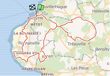
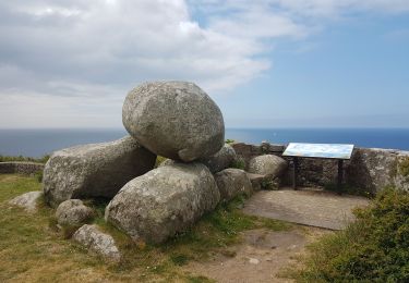
Ruta Bici de montaña de 25 km a descubrir en Normandía, Mancha, Tréauville. Esta ruta ha sido propuesta por tracegps.
Descripción
Un parcours qui limite les chasses boueuses, je n’aime pas la boue... Bref, un parcours de remise en forme. Bien sûr, il y a plein de variantes à partir de ce tracé et ça se fait trankilou en 1h45. Amusez vous bien !
Localización
País:
France
Región :
Normandía
Departamento/provincia :
Mancha
Municipio :
Tréauville
Localidad:
Unknown
Salida:(Dec)
Salida:(UTM)
582644 ; 5489585 (30U) N.
Comentarios
Excursiones cerca
![Excursión Senderismo Les Pieux - Entre terre et mer - Les Pieux - Photo](https://media.geolcdn.com/t/375/260/ext.jpg?maxdim=2&url=https%3A%2F%2Fservices.sitytrail.com%2FGeolivesWS%2FDownloadMedia.ashx%3FTrailID%3D173114%26Media%3D14665_6.jpg)
![Senderismo Senderismo](https://static1.geolcdn.com/sitytour/trail-icons/101.png)
Entre terre et mer - Les Pieux
Senderismo
Medio
(2)
Les Pieux,
Normandía,
Mancha,
France
![](/images/other/stat-length.png)
23 km | 28 km-effort
6h 0min
![](https://static1.geolcdn.com/siteimages/upload/files/16400158638029165_repeat_loop_refresh_sync_direction_icon.png)
Sí
![Excursión Senderismo La Hague - ioupi biville 01 - Photo](https://media.geolcdn.com/t/375/260/ext.jpg?maxdim=2&url=https%3A%2F%2Fstatic1.geolcdn.com%2Fsiteimages%2Fupload%2Ffiles%2F1553511878bg_sport_marche.png)
![Senderismo Senderismo](https://static1.geolcdn.com/sitytour/trail-icons/101.png)
ioupi biville 01
Senderismo
Fácil
(1)
La Hague,
Normandía,
Mancha,
France
![](/images/other/stat-length.png)
9,5 km | 11,3 km-effort
2h 11min
![](https://static1.geolcdn.com/siteimages/upload/files/16400158638029165_repeat_loop_refresh_sync_direction_icon.png)
Sí
![Excursión Senderismo Flamanville - Flamanville - Photo](https://media.geolcdn.com/t/375/260/0e1b6508-1f38-4364-b546-937920ff6bcb.jpg&format=jpg&maxdim=2)
![Senderismo Senderismo](https://static1.geolcdn.com/sitytour/trail-icons/101.png)
Flamanville
Senderismo
Medio
Flamanville,
Normandía,
Mancha,
France
![](/images/other/stat-length.png)
9,6 km | 12 km-effort
1h 58min
![](https://static1.geolcdn.com/siteimages/upload/files/16400158638029165_repeat_loop_refresh_sync_direction_icon.png)
Sí
![Excursión Senderismo Héauville - Béquille - blockhaus-plage Dielette port et retour - Photo](https://media.geolcdn.com/t/375/260/24a1d21a-2f16-4a52-90ca-70465c1624dd.jpg&format=jpg&maxdim=2)
![Senderismo Senderismo](https://static1.geolcdn.com/sitytour/trail-icons/101.png)
Béquille - blockhaus-plage Dielette port et retour
Senderismo
Fácil
Héauville,
Normandía,
Mancha,
France
![](/images/other/stat-length.png)
11,8 km | 13,5 km-effort
3h 10min
![](https://static1.geolcdn.com/siteimages/upload/files/16400158638029165_repeat_loop_refresh_sync_direction_icon.png)
No
![Excursión Senderismo Flamanville - Tour du cap de Flamanville - Photo](https://media.geolcdn.com/t/375/260/d462f6fc-820d-477d-8bd6-c4583a3ed315.jpg&format=jpg&maxdim=2)
![Senderismo Senderismo](https://static1.geolcdn.com/sitytour/trail-icons/101.png)
Tour du cap de Flamanville
Senderismo
Difícil
Flamanville,
Normandía,
Mancha,
France
![](/images/other/stat-length.png)
11,5 km | 14,6 km-effort
4h 0min
![](https://static1.geolcdn.com/siteimages/upload/files/16400158638029165_repeat_loop_refresh_sync_direction_icon.png)
Sí
![Excursión Bici de montaña Flamanville - Rando des Caps 2013 - 65 km - Flamanville - Photo](https://media.geolcdn.com/t/375/260/ext.jpg?maxdim=2&url=https%3A%2F%2Fservices.sitytrail.com%2FGeolivesWS%2FDownloadMedia.ashx%3FTrailID%3D215249%26Media%3D15453_4.jpg)
![Bici de montaña Bici de montaña](https://static1.geolcdn.com/sitytour/trail-icons/202.png)
Rando des Caps 2013 - 65 km - Flamanville
Bici de montaña
Difícil
Flamanville,
Normandía,
Mancha,
France
![](/images/other/stat-length.png)
60 km | 73 km-effort
3h 30min
![](https://static1.geolcdn.com/siteimages/upload/files/16400158638029165_repeat_loop_refresh_sync_direction_icon.png)
Sí
![Excursión Bici de montaña Flamanville - Rando des Caps 2013 - Flamanville - Photo](https://media.geolcdn.com/t/375/260/ext.jpg?maxdim=2&url=https%3A%2F%2Fservices.sitytrail.com%2FGeolivesWS%2FDownloadMedia.ashx%3FTrailID%3D214893%26Media%3D15444_3.jpg)
![Bici de montaña Bici de montaña](https://static1.geolcdn.com/sitytour/trail-icons/202.png)
Rando des Caps 2013 - Flamanville
Bici de montaña
Difícil
Flamanville,
Normandía,
Mancha,
France
![](/images/other/stat-length.png)
41 km | 48 km-effort
2h 45min
![](https://static1.geolcdn.com/siteimages/upload/files/16400158638029165_repeat_loop_refresh_sync_direction_icon.png)
Sí
![Excursión Carrera Les Pieux - Entre terre et mer - Les Pieux - Photo](https://media.geolcdn.com/t/375/260/ext.jpg?maxdim=2&url=https%3A%2F%2Fservices.sitytrail.com%2FGeolivesWS%2FDownloadMedia.ashx%3FTrailID%3D173115%26Media%3D14665_6.jpg)
![Carrera Carrera](https://static1.geolcdn.com/sitytour/trail-icons/103.png)
Entre terre et mer - Les Pieux
Carrera
Difícil
Les Pieux,
Normandía,
Mancha,
France
![](/images/other/stat-length.png)
23 km | 28 km-effort
3h 0min
![](https://static1.geolcdn.com/siteimages/upload/files/16400158638029165_repeat_loop_refresh_sync_direction_icon.png)
Sí
![Excursión Senderismo Flamanville - 21 Aout Flamanville plage du sciotot boucle terre et mer - Photo](https://media.geolcdn.com/t/375/260/ext.jpg?maxdim=2&url=https%3A%2F%2Fstatic1.geolcdn.com%2Fsiteimages%2Fupload%2Ffiles%2F1553511878bg_sport_marche.png)
![Senderismo Senderismo](https://static1.geolcdn.com/sitytour/trail-icons/101.png)
21 Aout Flamanville plage du sciotot boucle terre et mer
Senderismo
Muy difícil
Flamanville,
Normandía,
Mancha,
France
![](/images/other/stat-length.png)
22 km | 27 km-effort
5h 26min
![](https://static1.geolcdn.com/siteimages/upload/files/16400158638029165_repeat_loop_refresh_sync_direction_icon.png)
Sí