![](/images/other/stat-length.png)
![Excursión Senderismo Istres - Entre ville et nature - Istres - Photo](https://media.geolcdn.com/t/1900/400/ext.pjpeg?maxdim=2&url=https%3A%2F%2Fservices.sitytrail.com%2FGeolivesWS%2FDownloadMedia.ashx%3FTrailID%3D191380%26Media%3D14948_6.jpg)
Entre ville et nature - Istres
tracegps
Usuario
![Longitud](/images/other/stat-length.png)
![Altitud máxima](https://static1.geolcdn.com/siteimages/upload/files/1508320355ic_sort_altitude_max_24dp.png)
![Desnivel positivo](https://static1.geolcdn.com/siteimages/upload/files/1508320355ic_sort_den_pos_24dp.png)
![Km-Effort](/images/other/stat-length.png)
![Altitud mínima](https://static1.geolcdn.com/siteimages/upload/files/1508320355ic_sort_altitude_min_24dp.png)
![Desnivel negativo](https://static1.geolcdn.com/siteimages/upload/files/1508320355ic_sort_den_neg_24dp.png)
![Boucle](https://static1.geolcdn.com/siteimages/upload/files/16400158638029165_repeat_loop_refresh_sync_direction_icon.png)
![Senderismo](https://static1.geolcdn.com/sitytour/trail-icons/101.png)
4h00
Dificultad : Difícil
![Escanee este código QR para abrir la excursión en la aplicación SityTrail](https://capi.geolives.com/qq0zvz2zws4bq2lad0pu/sitytour/trails/191380/qr.png?size=200)
Aplicación GPS de excursión GRATIS
A propósito
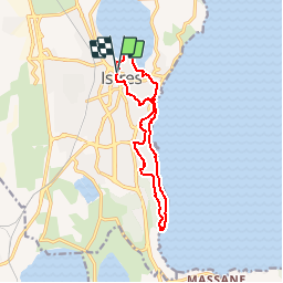
Ruta Senderismo de 12,3 km a descubrir en Provenza-Alpes-Costa Azul, Bocas del Ródano, Istres. Esta ruta ha sido propuesta por tracegps.
Descripción
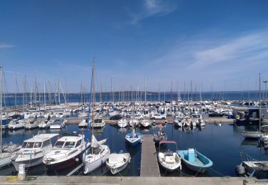
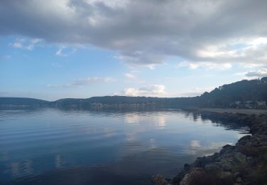
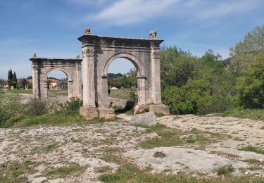
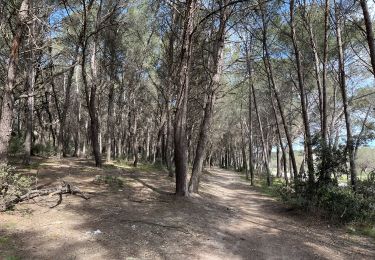
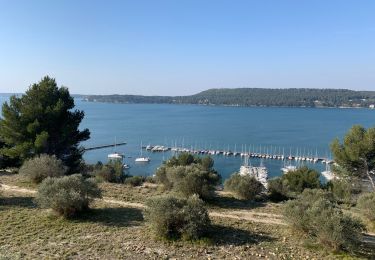
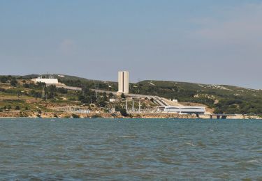
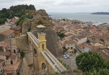
Circuit proposé? et au départ de l'Office de Tourisme d'Istres, 30 allée Jean Jaurès. Avez-vous souvent l’occasion lors d’une randonnée de mélanger patrimoine urbain et nature ? C’est ce que vous propose ce circuit insolite. Parcourez le centre historique et la ville pour plonger dans l’ambiance typique des villages provençaux. Découvrez aussi l’étang de Berre sous différents angles de vues. Surplombez le depuis les belvédères. Laissez glisser votre regard sur la plus grande mer intérieure d’Europe et son histoire complexe. Longez le littoral et profitez des criques préservées. Un rendez-vous à ne pas manquer !
Localización
Comentarios
Excursiones cerca
![Excursión A pie Istres - Entre ville et nature (Istres) - Photo](https://media.geolcdn.com/t/375/260/c6b4632a-eacc-47f8-8cb4-22741d911e31.jpeg&format=jpg&maxdim=2)
![A pie A pie](https://static1.geolcdn.com/sitytour/trail-icons/100.png)
A pie
![](/images/other/stat-length.png)
![](https://static1.geolcdn.com/siteimages/upload/files/16400158638029165_repeat_loop_refresh_sync_direction_icon.png)
![Excursión Senderismo Istres - Miramas Istres GR 2013 ALLER - Photo](https://media.geolcdn.com/t/375/260/ext.jpg?maxdim=2&url=https%3A%2F%2Fstatic1.geolcdn.com%2Fsiteimages%2Fupload%2Ffiles%2F1553511878bg_sport_marche.png)
![Senderismo Senderismo](https://static1.geolcdn.com/sitytour/trail-icons/101.png)
Senderismo
![](/images/other/stat-length.png)
![](https://static1.geolcdn.com/siteimages/upload/files/16400158638029165_repeat_loop_refresh_sync_direction_icon.png)
![Excursión Senderismo Istres - Le Ranquet-Istres 30.11.24 - Photo](https://media.geolcdn.com/t/375/260/edae3387-dbd2-44f3-a355-b8e1e68c6a61.jpg&format=jpg&maxdim=2)
![Senderismo Senderismo](https://static1.geolcdn.com/sitytour/trail-icons/101.png)
Senderismo
![](/images/other/stat-length.png)
![](https://static1.geolcdn.com/siteimages/upload/files/16400158638029165_repeat_loop_refresh_sync_direction_icon.png)
![Excursión Senderismo Saint-Chamas - St Chamas la Touloubre - Photo](https://media.geolcdn.com/t/375/260/f9f7571a-d63b-4c1d-b704-b5de87e678de.jpg&format=jpg&maxdim=2)
![Senderismo Senderismo](https://static1.geolcdn.com/sitytour/trail-icons/101.png)
Senderismo
![](/images/other/stat-length.png)
![](https://static1.geolcdn.com/siteimages/upload/files/16400158638029165_repeat_loop_refresh_sync_direction_icon.png)
![Excursión Senderismo Istres - Martigues entre les étangs de Citis et Lavalduc - Photo](https://media.geolcdn.com/t/375/260/3676fb10-77ad-438e-9273-065789ad9a3e.jpg&format=jpg&maxdim=2)
![Senderismo Senderismo](https://static1.geolcdn.com/sitytour/trail-icons/101.png)
Senderismo
![](/images/other/stat-length.png)
![](https://static1.geolcdn.com/siteimages/upload/files/16400158638029165_repeat_loop_refresh_sync_direction_icon.png)
![Excursión Senderismo Saint-Chamas - St chamas - Photo](https://media.geolcdn.com/t/375/260/4cbc1327-bf0c-4677-b2ac-6b2dc9c3ea9b.jpg&format=jpg&maxdim=2)
![Senderismo Senderismo](https://static1.geolcdn.com/sitytour/trail-icons/101.png)
Senderismo
![](/images/other/stat-length.png)
![](https://static1.geolcdn.com/siteimages/upload/files/16400158638029165_repeat_loop_refresh_sync_direction_icon.png)
![Excursión A pie Saint-Chamas - La petite Camargue - Photo](https://media.geolcdn.com/t/375/260/a1645164-0975-4adb-8824-f0171283f613.jpeg&format=jpg&maxdim=2)
![A pie A pie](https://static1.geolcdn.com/sitytour/trail-icons/100.png)
A pie
![](/images/other/stat-length.png)
![](https://static1.geolcdn.com/siteimages/upload/files/16400158638029165_repeat_loop_refresh_sync_direction_icon.png)
![Excursión Senderismo Berre-l'Étang - St Chamas variante patrimoine - Photo](https://media.geolcdn.com/t/375/260/9d09f0ff-03c0-4c52-a69c-b23e93dcf329.jpg&format=jpg&maxdim=2)
![Senderismo Senderismo](https://static1.geolcdn.com/sitytour/trail-icons/101.png)
Senderismo
![](/images/other/stat-length.png)
![](https://static1.geolcdn.com/siteimages/upload/files/16400158638029165_repeat_loop_refresh_sync_direction_icon.png)
![Excursión Senderismo Berre-l'Étang - chamas .Miramas. - Photo](https://media.geolcdn.com/t/375/260/002892a4-8f8d-4fe9-9171-0940ca663d27.jpg&format=jpg&maxdim=2)
![Senderismo Senderismo](https://static1.geolcdn.com/sitytour/trail-icons/101.png)
Senderismo
![](/images/other/stat-length.png)
![](https://static1.geolcdn.com/siteimages/upload/files/16400158638029165_repeat_loop_refresh_sync_direction_icon.png)
très agréable