![](/images/other/stat-length.png)
![Excursión Senderismo Lachapelle-aux-Pots - Lachapelle-aux-Pots - le bocage brayon 12 - Photo](https://media.geolcdn.com/t/1900/400/ext.pjpeg?maxdim=2&url=https%3A%2F%2Fstatic1.geolcdn.com%2Fsiteimages%2Fupload%2Ffiles%2F1553511878bg_sport_marche.png)
Lachapelle-aux-Pots - le bocage brayon 12
marcel.F
Usuario
![Longitud](/images/other/stat-length.png)
Longitud
11,9 km
![Altitud máxima](https://static1.geolcdn.com/siteimages/upload/files/1508320355ic_sort_altitude_max_24dp.png)
Altitud máxima
181 m
![Desnivel positivo](https://static1.geolcdn.com/siteimages/upload/files/1508320355ic_sort_den_pos_24dp.png)
Desnivel positivo
211 m
![Km-Effort](/images/other/stat-length.png)
Km-Effort
14,7 km
![Altitud mínima](https://static1.geolcdn.com/siteimages/upload/files/1508320355ic_sort_altitude_min_24dp.png)
Altitud mínima
95 m
![Desnivel negativo](https://static1.geolcdn.com/siteimages/upload/files/1508320355ic_sort_den_neg_24dp.png)
Desnivel negativo
211 m
![Boucle](https://static1.geolcdn.com/siteimages/upload/files/16400158638029165_repeat_loop_refresh_sync_direction_icon.png)
Boucle
Sí
Fecha de creación :
2014-12-10 00:00:00.0
Última modificación :
2014-12-10 00:00:00.0
![Senderismo](https://static1.geolcdn.com/sitytour/trail-icons/101.png)
3h10
Dificultad : Medio
![Escanee este código QR para abrir la excursión en la aplicación SityTrail](https://capi.geolives.com/qq0zvz2zws4bq2lad0pu/sitytour/trails/185529/qr.png?size=200)
Aplicación GPS de excursión GRATIS
A propósito
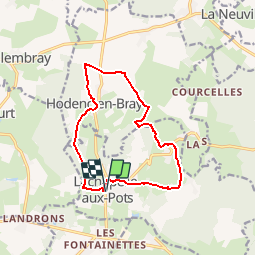
Ruta Senderismo de 11,9 km a descubrir en Alta Francia, Oise, Lachapelle-aux-Pots. Esta ruta ha sido propuesta por marcel.F.
Descripción
Boucle longue au départ du parking de la mairie de Lachapelle-aux-Pots
via Hodenc-en-Bray
Localización
País:
France
Región :
Alta Francia
Departamento/provincia :
Oise
Municipio :
Lachapelle-aux-Pots
Localidad:
Unknown
Salida:(Dec)
Salida:(UTM)
420383 ; 5477738 (31U) N.
Comentarios
Excursiones cerca
![Excursión Bici de montaña Lachapelle-aux-Pots - ACTIVE LOG 003 - Photo](https://media.geolcdn.com/t/375/260/ext.jpg?maxdim=2&url=https%3A%2F%2Fstatic1.geolcdn.com%2Fsiteimages%2Fupload%2Ffiles%2F1524743154velo.jpg)
![Bici de montaña Bici de montaña](https://static1.geolcdn.com/sitytour/trail-icons/202.png)
ACTIVE LOG 003
Bici de montaña
Medio
(1)
Lachapelle-aux-Pots,
Alta Francia,
Oise,
France
![](/images/other/stat-length.png)
19,1 km | 24 km-effort
1h 39min
![](https://static1.geolcdn.com/siteimages/upload/files/16400158638029165_repeat_loop_refresh_sync_direction_icon.png)
Sí
![Excursión Bici de montaña Pierrefitte-en-Beauvaisis - Grand tour - Photo](https://media.geolcdn.com/t/375/260/ext.jpg?maxdim=2&url=https%3A%2F%2Fstatic1.geolcdn.com%2Fsiteimages%2Fupload%2Ffiles%2F1524743154velo.jpg)
![Bici de montaña Bici de montaña](https://static1.geolcdn.com/sitytour/trail-icons/202.png)
Grand tour
Bici de montaña
(1)
Pierrefitte-en-Beauvaisis,
Alta Francia,
Oise,
France
![](/images/other/stat-length.png)
30 km | 35 km-effort
1h 44min
![](https://static1.geolcdn.com/siteimages/upload/files/16400158638029165_repeat_loop_refresh_sync_direction_icon.png)
Sí
![Excursión Senderismo Senantes - Senantes - Photo](https://media.geolcdn.com/t/375/260/f6921859-4933-4cab-b0ea-93545be25606.jpg&format=jpg&maxdim=2)
![Senderismo Senderismo](https://static1.geolcdn.com/sitytour/trail-icons/101.png)
![Excursión Senderismo Savignies - savignies - Photo](https://media.geolcdn.com/t/375/260/ext.jpg?maxdim=2&url=https%3A%2F%2Fstatic1.geolcdn.com%2Fsiteimages%2Fupload%2Ffiles%2F1553511878bg_sport_marche.png)
![Senderismo Senderismo](https://static1.geolcdn.com/sitytour/trail-icons/101.png)
![Excursión Senderismo Lachapelle-aux-Pots - Lachapelle-aux-pots - Héricourt - La Frénoye - Armentières - Photo](https://media.geolcdn.com/t/375/260/ext.jpg?maxdim=2&url=https%3A%2F%2Fstatic1.geolcdn.com%2Fsiteimages%2Fupload%2Ffiles%2F1553511878bg_sport_marche.png)
![Senderismo Senderismo](https://static1.geolcdn.com/sitytour/trail-icons/101.png)
Lachapelle-aux-pots - Héricourt - La Frénoye - Armentières
Senderismo
Difícil
Lachapelle-aux-Pots,
Alta Francia,
Oise,
France
![](/images/other/stat-length.png)
10,7 km | 13,7 km-effort
3h 6min
![](https://static1.geolcdn.com/siteimages/upload/files/16400158638029165_repeat_loop_refresh_sync_direction_icon.png)
Sí
![Excursión Senderismo Lachapelle-aux-Pots - Lachapelle aux pots - Armentières 11 km - Photo](https://media.geolcdn.com/t/375/260/ext.jpg?maxdim=2&url=https%3A%2F%2Fstatic1.geolcdn.com%2Fsiteimages%2Fupload%2Ffiles%2F1553511878bg_sport_marche.png)
![Senderismo Senderismo](https://static1.geolcdn.com/sitytour/trail-icons/101.png)
Lachapelle aux pots - Armentières 11 km
Senderismo
Difícil
Lachapelle-aux-Pots,
Alta Francia,
Oise,
France
![](/images/other/stat-length.png)
10,6 km | 13,5 km-effort
3h 4min
![](https://static1.geolcdn.com/siteimages/upload/files/16400158638029165_repeat_loop_refresh_sync_direction_icon.png)
Sí
![Excursión Senderismo Lachapelle-aux-Pots - Lachapelle aux Pots - Rando santé 1 - Photo](https://media.geolcdn.com/t/375/260/ext.jpg?maxdim=2&url=https%3A%2F%2Fstatic1.geolcdn.com%2Fsiteimages%2Fupload%2Ffiles%2F1553511878bg_sport_marche.png)
![Senderismo Senderismo](https://static1.geolcdn.com/sitytour/trail-icons/101.png)
Lachapelle aux Pots - Rando santé 1
Senderismo
Medio
Lachapelle-aux-Pots,
Alta Francia,
Oise,
France
![](/images/other/stat-length.png)
5,6 km | 6,4 km-effort
1h 24min
![](https://static1.geolcdn.com/siteimages/upload/files/16400158638029165_repeat_loop_refresh_sync_direction_icon.png)
Sí
![Excursión Senderismo Lachapelle-aux-Pots - Lachapelle-aux-Pots - autour de la Crapaudière vers 2 - Photo](https://media.geolcdn.com/t/375/260/ext.jpg?maxdim=2&url=https%3A%2F%2Fstatic1.geolcdn.com%2Fsiteimages%2Fupload%2Ffiles%2F1553511878bg_sport_marche.png)
![Senderismo Senderismo](https://static1.geolcdn.com/sitytour/trail-icons/101.png)
Lachapelle-aux-Pots - autour de la Crapaudière vers 2
Senderismo
Fácil
Lachapelle-aux-Pots,
Alta Francia,
Oise,
France
![](/images/other/stat-length.png)
9,9 km | 11,5 km-effort
2h 32min
![](https://static1.geolcdn.com/siteimages/upload/files/16400158638029165_repeat_loop_refresh_sync_direction_icon.png)
Sí
![Excursión Senderismo Lachapelle-aux-Pots - Lachapelle-aux-Pots - autour de la Crapaudière - Photo](https://media.geolcdn.com/t/375/260/ext.jpg?maxdim=2&url=https%3A%2F%2Fstatic1.geolcdn.com%2Fsiteimages%2Fupload%2Ffiles%2F1553511878bg_sport_marche.png)
![Senderismo Senderismo](https://static1.geolcdn.com/sitytour/trail-icons/101.png)
Lachapelle-aux-Pots - autour de la Crapaudière
Senderismo
Fácil
Lachapelle-aux-Pots,
Alta Francia,
Oise,
France
![](/images/other/stat-length.png)
9,4 km | 10,9 km-effort
2h 25min
![](https://static1.geolcdn.com/siteimages/upload/files/16400158638029165_repeat_loop_refresh_sync_direction_icon.png)
Sí
beaucoup trop ombragé