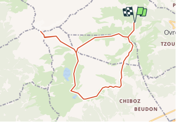
![](/images/other/stat-length.png)
![Excursión Otra actividad Leytron - Dt-Morcles et Tour du Chavalard (2''968 m) - Photo](https://media.geolcdn.com/t/1900/400/ext.pjpeg?maxdim=2&url=https%3A%2F%2Fstatic1.geolcdn.com%2Fsiteimages%2Fupload%2Ffiles%2F1545311037marcheuse_200dpi.jpg)
Dt-Morcles et Tour du Chavalard (2''968 m)
Romrando
Usuario
![Longitud](/images/other/stat-length.png)
![Altitud máxima](https://static1.geolcdn.com/siteimages/upload/files/1508320355ic_sort_altitude_max_24dp.png)
![Desnivel positivo](https://static1.geolcdn.com/siteimages/upload/files/1508320355ic_sort_den_pos_24dp.png)
![Km-Effort](/images/other/stat-length.png)
![Altitud mínima](https://static1.geolcdn.com/siteimages/upload/files/1508320355ic_sort_altitude_min_24dp.png)
![Desnivel negativo](https://static1.geolcdn.com/siteimages/upload/files/1508320355ic_sort_den_neg_24dp.png)
![Boucle](https://static1.geolcdn.com/siteimages/upload/files/16400158638029165_repeat_loop_refresh_sync_direction_icon.png)
![Otra actividad](https://static1.geolcdn.com/sitytour/trail-icons/900.png)
--
Dificultad : Desconocido
![Escanee este código QR para abrir la excursión en la aplicación SityTrail](https://capi.geolives.com/qq0zvz2zws4bq2lad0pu/sitytour/trails/18519/qr.png?size=200)
Aplicación GPS de excursión GRATIS
A propósito
Ruta Otra actividad de 18,5 km a descubrir en Vallés, Martigny, Leytron. Esta ruta ha sido propuesta por Romrando.
Descripción
Source:geocities.com/romrando - 26.7.05
Paysage très varié et aride vers le sommet. Vue spectaculaire sur le bas Valais.
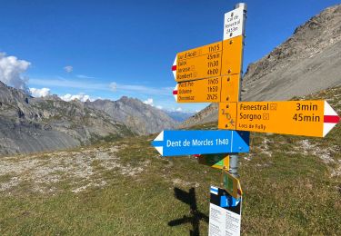
Itinéraire : D''Ovronnaz par le télésiège à Bougnone. Gagner par le flanc vers le sud le Petit Pré. Toujours vers le sud descendre quelque peu (sans aller au fond du vallon) mais prendre à droite un sentier qui rejoint plus ou moins horizontalement par les flancs l''alpage de "L''Erié" (possibilité de rejoindre cet endroit en voiture depuis Ovronnaz). Toujours horizontalement on contourne le Grand Chavalard par le sud pour atteindre le lac de Fully. Gagner le col de Fenestral et sa cabane (ouverte et à disposion toute l''année, gardée parfois).
Contourner un ressaut rocheux par L''W puis gagner une vaste combe. Suivre un sentier pas toujours bien marqué qui amène sous l''arête sud de la Dent de Morcles. Franchir quelques ressauts faciles et gagner le sommet.
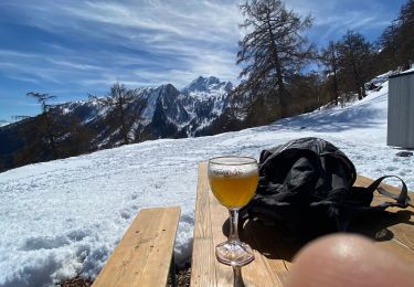
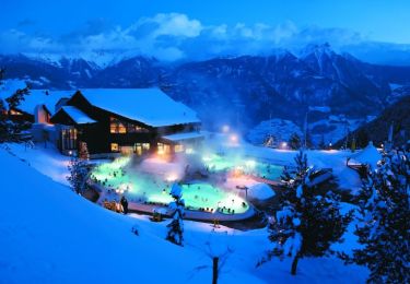
Descente par le Fenestral puis le grand plateau d''Euloi et retour sur Ovronnaz (à pied si l''on est trop tard pour le télésiège). Les bains thermaux concluent très agréablement la journée.
Localización
Comentarios
Excursiones cerca
![Excursión A pie Fully - Tour du Grand Chavalard - Photo](https://media.geolcdn.com/t/375/260/dev_67507fd3-861a-4ef5-97f2-010a7f511665.jpeg&format=jpg&maxdim=2)
![A pie A pie](https://static1.geolcdn.com/sitytour/trail-icons/100.png)
A pie
![](/images/other/stat-length.png)
![](https://static1.geolcdn.com/siteimages/upload/files/16400158638029165_repeat_loop_refresh_sync_direction_icon.png)
![Excursión Marcha nórdica Leytron - Ovronaz - Loutze - Ovronaz - Photo](https://media.geolcdn.com/t/375/260/ext.jpg?maxdim=2&url=https%3A%2F%2Fservices.sitytrail.com%2FGeolivesWS%2FDownloadMedia.ashx%3FTrailID%3D246200%26Media%3D20140201124820.jpg)
![Marcha nórdica Marcha nórdica](https://static1.geolcdn.com/sitytour/trail-icons/102.png)
Marcha nórdica
![](/images/other/stat-length.png)
![](https://static1.geolcdn.com/siteimages/upload/files/16400158638029165_repeat_loop_refresh_sync_direction_icon.png)
![Excursión Senderismo Leytron - Cabane Rambert - Photo](https://media.geolcdn.com/t/375/260/ext.jpg?maxdim=2&url=https%3A%2F%2Fservices.sitytrail.com%2FGeolivesWS%2FDownloadMedia.ashx%3FTrailID%3D209855%26Media%3D20130803134530.jpg)
![Senderismo Senderismo](https://static1.geolcdn.com/sitytour/trail-icons/101.png)
Senderismo
![](/images/other/stat-length.png)
![](https://static1.geolcdn.com/siteimages/upload/files/16400158638029165_repeat_loop_refresh_sync_direction_icon.png)
![Excursión Senderismo Leytron - 0vronnaz cabane FENESTRAL - Photo](https://media.geolcdn.com/t/375/260/9e828b15-70d6-4c01-9d2a-591b66af477f.jpg&format=jpg&maxdim=2)
![Senderismo Senderismo](https://static1.geolcdn.com/sitytour/trail-icons/101.png)
Senderismo
![](/images/other/stat-length.png)
![](https://static1.geolcdn.com/siteimages/upload/files/16400158638029165_repeat_loop_refresh_sync_direction_icon.png)
![Excursión Senderismo Chamoson - Ovronnaz - Photo](https://media.geolcdn.com/t/375/260/0b175b2c-bdb1-4f39-8772-d1c6dc09dbdc.jpg&format=jpg&maxdim=2)
![Senderismo Senderismo](https://static1.geolcdn.com/sitytour/trail-icons/101.png)
Senderismo
![](/images/other/stat-length.png)
![](https://static1.geolcdn.com/siteimages/upload/files/16400158638029165_repeat_loop_refresh_sync_direction_icon.png)
![Excursión Senderismo Leytron - Tour d'Ovronaz - Route des bains - Photo](https://media.geolcdn.com/t/375/260/ext.jpg?maxdim=2&url=https%3A%2F%2Fservices.sitytrail.com%2FGeolivesWS%2FDownloadMedia.ashx%3FTrailID%3D596427%26Media%3D3babb666-a844-4fe9-a5e0-8ddcda1a2c0c.jpg)
![Senderismo Senderismo](https://static1.geolcdn.com/sitytour/trail-icons/101.png)
Senderismo
![](/images/other/stat-length.png)
![](https://static1.geolcdn.com/siteimages/upload/files/16400158638029165_repeat_loop_refresh_sync_direction_icon.png)
![Excursión Bici de montaña Leytron - Bike32926 - Photo](https://media.geolcdn.com/t/375/260/ext.jpg?maxdim=2&url=https%3A%2F%2Fstatic1.geolcdn.com%2Fsiteimages%2Fupload%2Ffiles%2F1524743154velo.jpg)
![Bici de montaña Bici de montaña](https://static1.geolcdn.com/sitytour/trail-icons/202.png)
Bici de montaña
![](/images/other/stat-length.png)
![](https://static1.geolcdn.com/siteimages/upload/files/16400158638029165_repeat_loop_refresh_sync_direction_icon.png)
![Excursión Bicicleta Saillon - Martigny -Sion iii - Photo](https://media.geolcdn.com/t/375/260/ext.jpg?maxdim=2&url=https%3A%2F%2Fstatic1.geolcdn.com%2Fsiteimages%2Fupload%2Ffiles%2F1524743154velo.jpg)
![Bicicleta Bicicleta](https://static1.geolcdn.com/sitytour/trail-icons/200.png)
Bicicleta
![](/images/other/stat-length.png)
![](https://static1.geolcdn.com/siteimages/upload/files/16400158638029165_repeat_loop_refresh_sync_direction_icon.png)
![Excursión Raquetas de nieve Leytron - Ovronnaz - J1 - Tour du Grand Chateau - Photo](https://media.geolcdn.com/t/375/260/ext.jpg?maxdim=2&url=https%3A%2F%2Fstatic1.geolcdn.com%2Fsiteimages%2Fupload%2Ffiles%2F1524743153raquette.jpg)
![Raquetas de nieve Raquetas de nieve](https://static1.geolcdn.com/sitytour/trail-icons/504.png)
Raquetas de nieve
![](/images/other/stat-length.png)
![](https://static1.geolcdn.com/siteimages/upload/files/16400158638029165_repeat_loop_refresh_sync_direction_icon.png)