![](/images/other/stat-length.png)
![Excursión Senderismo Amfreville-la-Mi-Voie - Amfreville la-mi-voie (2) - Photo](https://media.geolcdn.com/t/1900/400/ext.pjpeg?maxdim=2&url=https%3A%2F%2Fstatic1.geolcdn.com%2Fsiteimages%2Fupload%2Ffiles%2F1553511878bg_sport_marche.png)
Amfreville la-mi-voie (2)
randovivi
Usuario
![Longitud](/images/other/stat-length.png)
Longitud
9,3 km
![Altitud máxima](https://static1.geolcdn.com/siteimages/upload/files/1508320355ic_sort_altitude_max_24dp.png)
Altitud máxima
156 m
![Desnivel positivo](https://static1.geolcdn.com/siteimages/upload/files/1508320355ic_sort_den_pos_24dp.png)
Desnivel positivo
198 m
![Km-Effort](/images/other/stat-length.png)
Km-Effort
11,9 km
![Altitud mínima](https://static1.geolcdn.com/siteimages/upload/files/1508320355ic_sort_altitude_min_24dp.png)
Altitud mínima
8 m
![Desnivel negativo](https://static1.geolcdn.com/siteimages/upload/files/1508320355ic_sort_den_neg_24dp.png)
Desnivel negativo
198 m
![Boucle](https://static1.geolcdn.com/siteimages/upload/files/16400158638029165_repeat_loop_refresh_sync_direction_icon.png)
Boucle
Sí
Fecha de creación :
2016-03-09 00:00:00.0
Última modificación :
2016-03-09 00:00:00.0
![Senderismo](https://static1.geolcdn.com/sitytour/trail-icons/101.png)
2h34
Dificultad : Medio
![Escanee este código QR para abrir la excursión en la aplicación SityTrail](https://capi.geolives.com/qq0zvz2zws4bq2lad0pu/sitytour/trails/175308/qr.png?size=200)
Aplicación GPS de excursión GRATIS
A propósito
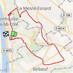
Ruta Senderismo de 9,3 km a descubrir en Normandía, Sena-Marítimo, Amfreville-la-Mi-Voie. Esta ruta ha sido propuesta por randovivi.
Descripción
Elle démarre par une bonne côte. Prendre les bâtons.Par la suite c''est plat ou de la descente.
Localización
País:
France
Región :
Normandía
Departamento/provincia :
Sena-Marítimo
Municipio :
Amfreville-la-Mi-Voie
Localidad:
Unknown
Salida:(Dec)
Salida:(UTM)
363942 ; 5473541 (31U) N.
Comentarios
Excursiones cerca
![Senderismo Senderismo](https://static1.geolcdn.com/sitytour/trail-icons/101.png)
076-34-le tour de Darnétal 13km 875-557
Senderismo
Medio
(1)
Darnétal,
Normandía,
Sena-Marítimo,
France
![](/images/other/stat-length.png)
9,8 km | 13,1 km-effort
3h 32min
![](https://static1.geolcdn.com/siteimages/upload/files/16400158638029165_repeat_loop_refresh_sync_direction_icon.png)
Sí
![Excursión Senderismo Ruan - 076-102--Bonsecours Darnetal par St Hilaire 13km- - Photo](https://media.geolcdn.com/t/375/260/df16cd3f-22de-4a98-ae5c-66d89f1fbe2e.jpg&format=jpg&maxdim=2)
![Senderismo Senderismo](https://static1.geolcdn.com/sitytour/trail-icons/101.png)
076-102--Bonsecours Darnetal par St Hilaire 13km-
Senderismo
Medio
(1)
Ruan,
Normandía,
Sena-Marítimo,
France
![](/images/other/stat-length.png)
13,1 km | 16 km-effort
21min
![](https://static1.geolcdn.com/siteimages/upload/files/16400158638029165_repeat_loop_refresh_sync_direction_icon.png)
Sí
![Excursión Senderismo Saint-Étienne-du-Rouvray - Forêt St. EtienneDu Rouvray P2 (86) - Photo](https://media.geolcdn.com/t/375/260/ext.jpg?maxdim=2&url=https%3A%2F%2Fstatic1.geolcdn.com%2Fsiteimages%2Fupload%2Ffiles%2F1553511878bg_sport_marche.png)
![Senderismo Senderismo](https://static1.geolcdn.com/sitytour/trail-icons/101.png)
Forêt St. EtienneDu Rouvray P2 (86)
Senderismo
Muy fácil
(1)
Saint-Étienne-du-Rouvray,
Normandía,
Sena-Marítimo,
France
![](/images/other/stat-length.png)
9,7 km | 10,7 km-effort
2h 23min
![](https://static1.geolcdn.com/siteimages/upload/files/16400158638029165_repeat_loop_refresh_sync_direction_icon.png)
Sí
![Excursión Senderismo Ruan - Découverte du Vieux Rouen - Photo](https://media.geolcdn.com/t/375/260/07f58fb9-e0a2-467d-b259-7f5f14d6fd45.jpg&format=jpg&maxdim=2)
![Senderismo Senderismo](https://static1.geolcdn.com/sitytour/trail-icons/101.png)
Découverte du Vieux Rouen
Senderismo
Medio
Ruan,
Normandía,
Sena-Marítimo,
France
![](/images/other/stat-length.png)
9,6 km | 10,6 km-effort
2h 23min
![](https://static1.geolcdn.com/siteimages/upload/files/16400158638029165_repeat_loop_refresh_sync_direction_icon.png)
Sí
![Senderismo Senderismo](https://static1.geolcdn.com/sitytour/trail-icons/101.png)
20240108-Darnetal
Senderismo
Medio
Darnétal,
Normandía,
Sena-Marítimo,
France
![](/images/other/stat-length.png)
10,1 km | 13,4 km-effort
3h 10min
![](https://static1.geolcdn.com/siteimages/upload/files/16400158638029165_repeat_loop_refresh_sync_direction_icon.png)
Sí
![Excursión Senderismo Quévreville-la-Poterie - 20240104-Quevreville la Potterie - Photo](https://media.geolcdn.com/t/375/260/0b8d8346-6b3b-4e80-8d5c-b85557b11606.jpg&format=jpg&maxdim=2)
![Senderismo Senderismo](https://static1.geolcdn.com/sitytour/trail-icons/101.png)
20240104-Quevreville la Potterie
Senderismo
Medio
Quévreville-la-Poterie,
Normandía,
Sena-Marítimo,
France
![](/images/other/stat-length.png)
9,2 km | 11,2 km-effort
2h 43min
![](https://static1.geolcdn.com/siteimages/upload/files/16400158638029165_repeat_loop_refresh_sync_direction_icon.png)
Sí
![Excursión Senderismo Quévreville-la-Poterie - 20231219-quevreville noel - Photo](https://media.geolcdn.com/t/375/260/9039af00-539b-4ef5-83fe-9bd657e6d749.jpg&format=jpg&maxdim=2)
![Senderismo Senderismo](https://static1.geolcdn.com/sitytour/trail-icons/101.png)
20231219-quevreville noel
Senderismo
Medio
Quévreville-la-Poterie,
Normandía,
Sena-Marítimo,
France
![](/images/other/stat-length.png)
10,3 km | 12,6 km-effort
2h 55min
![](https://static1.geolcdn.com/siteimages/upload/files/16400158638029165_repeat_loop_refresh_sync_direction_icon.png)
Sí
![Senderismo Senderismo](https://static1.geolcdn.com/sitytour/trail-icons/101.png)
20231109-Rouen
Senderismo
Fácil
Ruan,
Normandía,
Sena-Marítimo,
France
![](/images/other/stat-length.png)
3,2 km | 3,6 km-effort
57min
![](https://static1.geolcdn.com/siteimages/upload/files/16400158638029165_repeat_loop_refresh_sync_direction_icon.png)
Sí
![Senderismo Senderismo](https://static1.geolcdn.com/sitytour/trail-icons/101.png)
20230520-Amfreville la Mi Voie
Senderismo
Medio
Amfreville-la-Mi-Voie,
Normandía,
Sena-Marítimo,
France
![](/images/other/stat-length.png)
10,8 km | 13,9 km-effort
3h 4min
![](https://static1.geolcdn.com/siteimages/upload/files/16400158638029165_repeat_loop_refresh_sync_direction_icon.png)
Sí
ras
très beau circuit bravo à l'auteur