![](/images/other/stat-length.png)
![Excursión Senderismo Saint-Pierre-d'Entremont - La crête du Grand Manti par le Pas de la Mort - Photo](https://media.geolcdn.com/t/1900/400/ext.pjpeg?maxdim=2&url=https%3A%2F%2Fservices.sitytrail.com%2FGeolivesWS%2FDownloadMedia.ashx%3FTrailID%3D173034%26Media%3D14545_1.jpg)
La crête du Grand Manti par le Pas de la Mort
tracegps
Usuario
![Longitud](/images/other/stat-length.png)
![Altitud máxima](https://static1.geolcdn.com/siteimages/upload/files/1508320355ic_sort_altitude_max_24dp.png)
![Desnivel positivo](https://static1.geolcdn.com/siteimages/upload/files/1508320355ic_sort_den_pos_24dp.png)
![Km-Effort](/images/other/stat-length.png)
![Altitud mínima](https://static1.geolcdn.com/siteimages/upload/files/1508320355ic_sort_altitude_min_24dp.png)
![Desnivel negativo](https://static1.geolcdn.com/siteimages/upload/files/1508320355ic_sort_den_neg_24dp.png)
![Boucle](https://static1.geolcdn.com/siteimages/upload/files/16400158638029165_repeat_loop_refresh_sync_direction_icon.png)
![Senderismo](https://static1.geolcdn.com/sitytour/trail-icons/101.png)
6h45
Dificultad : Difícil
![Escanee este código QR para abrir la excursión en la aplicación SityTrail](https://capi.geolives.com/qq0zvz2zws4bq2lad0pu/sitytour/trails/173034/qr.png?size=200)
Aplicación GPS de excursión GRATIS
A propósito
Ruta Senderismo de 9,4 km a descubrir en Auvergne-Rhône-Alpes, Saboya, Saint-Pierre-d'Entremont. Esta ruta ha sido propuesta por tracegps.
Descripción
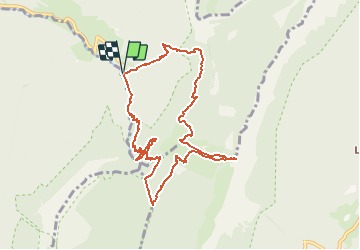
Chartreuse Orientale. Depuis le parking du Cirque de Saint-Même, le Pas de la Mort est un passage logique, pour atteindre l'Alpette des Dames et de là gravir la croupe herbeuse caractéristique jusqu'à la crête du Grand Manti vers 1800 mètres. La descente par le Habert de la Dame va chercher le beau Chemin de Tracarta qui ramène à la Fontaine de Rigne Bâton. Plus bas sur le chemin des Varvats, un vieux sentier raide et aventureux, dévale les pentes soutenues, jusqu'au point de départ. Description complète sur sentier-nature.com : La crête du Grand Manti par le Pas de la Mort Avertissement [Franchissement 2/3 ; Exposition 2/3 ; Orientation 1/3]. Certains passages de cet itinéraire de montagne sont escarpés et/ou exposés, il est déconseillé aux enfants non accompagnés et aux personnes sujettes au vertige. Pour votre sécurité, nous vous invitons à respecter les règles suivantes : être bien chaussé, ne pas s'engager par mauvais temps, ne pas s'écarter de l'itinéraire ni des sentiers. Pour assurer les moins expérimentés, une corde d'une vingtaine de mètres peut être utile. Il apparaît souhaitable de réaliser cette course par temps sec. Cet itinéraire ce déroule tout ou partie dans la Réserve Naturelle des Hauts de Chartreuse qui a pour mission d'étudier et de gérer ce territoire afin que les diverses activités qui s'y exercent (élevage, exploitation forestière, randonnée, etc.) soient compatibles avec la préservation de la faune, de la flore et du paysage.
Localización
Comentarios
Excursiones cerca
![Excursión Senderismo Saint-Pierre-d'Entremont - chartreuse varvats fouda blanc pinet - Photo](https://media.geolcdn.com/t/375/260/3ade212f-cb78-41d4-b551-255bd725eded.jpg&format=jpg&maxdim=2)
![Senderismo Senderismo](https://static1.geolcdn.com/sitytour/trail-icons/101.png)
Senderismo
![](/images/other/stat-length.png)
![](https://static1.geolcdn.com/siteimages/upload/files/16400158638029165_repeat_loop_refresh_sync_direction_icon.png)
![Excursión Senderismo Saint-Pierre-d'Entremont - Le Grand Som 2026m, depuis Saint-Philibert - Photo](https://media.geolcdn.com/t/375/260/ext.jpg?maxdim=2&url=https%3A%2F%2Fservices.sitytrail.com%2FGeolivesWS%2FDownloadMedia.ashx%3FTrailID%3D107472%26Media%3D12415_1.jpg)
![Senderismo Senderismo](https://static1.geolcdn.com/sitytour/trail-icons/101.png)
Senderismo
![](/images/other/stat-length.png)
![](https://static1.geolcdn.com/siteimages/upload/files/16400158638029165_repeat_loop_refresh_sync_direction_icon.png)
![Excursión Senderismo Sainte-Marie-du-Mont - Les Belles Ombres - Sangle et Rochers - Sainte Marie du Mont - Photo](https://media.geolcdn.com/t/375/260/ext.jpg?maxdim=2&url=https%3A%2F%2Fservices.sitytrail.com%2FGeolivesWS%2FDownloadMedia.ashx%3FTrailID%3D106447%26Media%3D10957_1.jpg)
![Senderismo Senderismo](https://static1.geolcdn.com/sitytour/trail-icons/101.png)
Senderismo
![](/images/other/stat-length.png)
![](https://static1.geolcdn.com/siteimages/upload/files/16400158638029165_repeat_loop_refresh_sync_direction_icon.png)
![Excursión Raquetas de nieve Saint-Pierre-d'Entremont - La Croix de l'Alpe depuis les Varvats - Photo](https://media.geolcdn.com/t/375/260/ext.jpg?maxdim=2&url=https%3A%2F%2Fservices.sitytrail.com%2FGeolivesWS%2FDownloadMedia.ashx%3FTrailID%3D103120%26Media%3D4867_1.jpg)
![Raquetas de nieve Raquetas de nieve](https://static1.geolcdn.com/sitytour/trail-icons/504.png)
Raquetas de nieve
![](/images/other/stat-length.png)
![](https://static1.geolcdn.com/siteimages/upload/files/16400158638029165_repeat_loop_refresh_sync_direction_icon.png)
![Excursión Senderismo Saint-Pierre-d'Entremont - Roche Veyrand par les Clapiers, 1429m - Photo](https://media.geolcdn.com/t/375/260/ext.jpg?maxdim=2&url=https%3A%2F%2Fservices.sitytrail.com%2FGeolivesWS%2FDownloadMedia.ashx%3FTrailID%3D101734%26Media%3D1981_1.jpg)
![Senderismo Senderismo](https://static1.geolcdn.com/sitytour/trail-icons/101.png)
Senderismo
![](/images/other/stat-length.png)
![](https://static1.geolcdn.com/siteimages/upload/files/16400158638029165_repeat_loop_refresh_sync_direction_icon.png)
![Excursión Senderismo Saint-Vincent-de-Mercuze - 38 cascades d alloix - Photo](https://media.geolcdn.com/t/375/260/ac959965-e9e6-43ac-868c-d1afc5ef4777.jpg&format=jpg&maxdim=2)
![Senderismo Senderismo](https://static1.geolcdn.com/sitytour/trail-icons/101.png)
Senderismo
![](/images/other/stat-length.png)
![](https://static1.geolcdn.com/siteimages/upload/files/16400158638029165_repeat_loop_refresh_sync_direction_icon.png)
![Excursión Senderismo Sainte-Marie-du-Mont - Passage de la Rousse - Photo](https://media.geolcdn.com/t/375/260/3d59ba9c-1b18-4c8b-84d9-d9ac619ac9d2.jpg&format=jpg&maxdim=2)
![Senderismo Senderismo](https://static1.geolcdn.com/sitytour/trail-icons/101.png)
Senderismo
![](/images/other/stat-length.png)
![](https://static1.geolcdn.com/siteimages/upload/files/16400158638029165_repeat_loop_refresh_sync_direction_icon.png)
![Excursión Senderismo Sainte-Marie-du-Mont - Rocher de Belle ombre et ses arches - Photo](https://media.geolcdn.com/t/375/260/d41d4591-aff2-44cd-b615-de2c0388e17f.jpg&format=jpg&maxdim=2)
![Senderismo Senderismo](https://static1.geolcdn.com/sitytour/trail-icons/101.png)
Senderismo
![](/images/other/stat-length.png)
![](https://static1.geolcdn.com/siteimages/upload/files/16400158638029165_repeat_loop_refresh_sync_direction_icon.png)
![Excursión Senderismo Saint-Vincent-de-Mercuze - Grande cascade de Montalieu - Photo](https://media.geolcdn.com/t/375/260/ext.jpg?maxdim=2&url=https%3A%2F%2Fstatic1.geolcdn.com%2Fsiteimages%2Fupload%2Ffiles%2F1553511878bg_sport_marche.png)
![Senderismo Senderismo](https://static1.geolcdn.com/sitytour/trail-icons/101.png)
Senderismo
![](/images/other/stat-length.png)
![](https://static1.geolcdn.com/siteimages/upload/files/16400158638029165_repeat_loop_refresh_sync_direction_icon.png)