![](/images/other/stat-length.png)
![Excursión Senderismo Ghisoni - Punta a a Cappella - Photo](https://media.geolcdn.com/t/1900/400/ext.pjpeg?maxdim=2&url=https%3A%2F%2Fservices.sitytrail.com%2FGeolivesWS%2FDownloadMedia.ashx%3FTrailID%3D172934%26Media%3D14410_6.jpg)
Punta a a Cappella
tracegps
Usuario
![Longitud](/images/other/stat-length.png)
![Altitud máxima](https://static1.geolcdn.com/siteimages/upload/files/1508320355ic_sort_altitude_max_24dp.png)
![Desnivel positivo](https://static1.geolcdn.com/siteimages/upload/files/1508320355ic_sort_den_pos_24dp.png)
![Km-Effort](/images/other/stat-length.png)
![Altitud mínima](https://static1.geolcdn.com/siteimages/upload/files/1508320355ic_sort_altitude_min_24dp.png)
![Desnivel negativo](https://static1.geolcdn.com/siteimages/upload/files/1508320355ic_sort_den_neg_24dp.png)
![Boucle](https://static1.geolcdn.com/siteimages/upload/files/16400158638029165_repeat_loop_refresh_sync_direction_icon.png)
![Senderismo](https://static1.geolcdn.com/sitytour/trail-icons/101.png)
8h00
Dificultad : Medio
![Escanee este código QR para abrir la excursión en la aplicación SityTrail](https://capi.geolives.com/qq0zvz2zws4bq2lad0pu/sitytour/trails/172934/qr.png?size=200)
Aplicación GPS de excursión GRATIS
A propósito
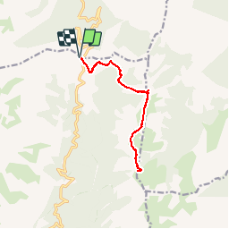
Ruta Senderismo de 13,7 km a descubrir en Córcega, Alta Córcega, Ghisoni. Esta ruta ha sido propuesta por tracegps.
Descripción
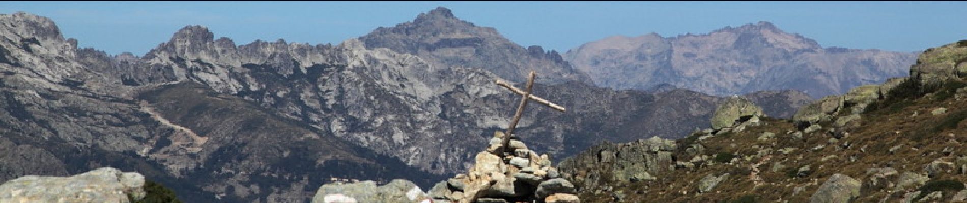
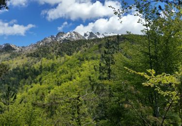
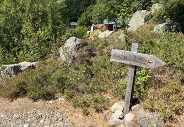
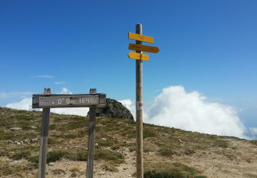
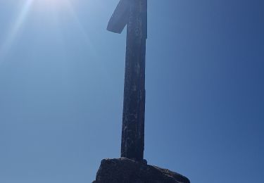
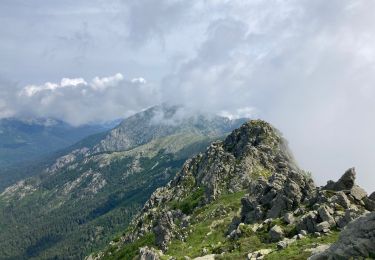
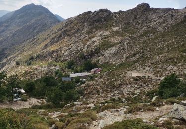
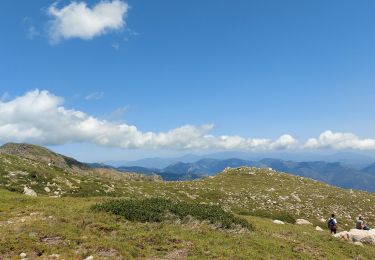
Avec ses 2041 mètres d'altitude, Punta a a Cappella est le point culminant du chaînon dominant la micro-région du Fiumorbo sur la cote Est de la Corse. Ce sommet offre un panorama exceptionnel, non seulement sur la côte, mais aussi sur Monte Renoso et les massifs qui entourent ce dernier et sur de nombreux sommets plus éloignés. A l'exception de l'ascension finale, le cheminement emprunte le GR20 et ne présente donc aucune difficulté d'orientation tout en proposant un environnement agréable et varié. Ce sommet mériterait de faire partie des grandes classiques parmi les randonnées en Corse. D'autres photos et le récit de la randonnée ICI .
Localización
Comentarios
Excursiones cerca
![Excursión Senderismo Ghisoni - Ballade col de Verde - Photo](https://media.geolcdn.com/t/375/260/ext.jpg?maxdim=2&url=https%3A%2F%2Fservices.sitytrail.com%2FGeolivesWS%2FDownloadMedia.ashx%3FTrailID%3D744648%26Media%3Dfix__20170502131131.jpg)
![Senderismo Senderismo](https://static1.geolcdn.com/sitytour/trail-icons/101.png)
Senderismo
![](/images/other/stat-length.png)
![](https://static1.geolcdn.com/siteimages/upload/files/16400158638029165_repeat_loop_refresh_sync_direction_icon.png)
![Excursión Senderismo Palneca - Col de Verde usciulu - Photo](https://media.geolcdn.com/t/375/260/301cd8a5-6815-4753-af34-c00c3e606eef.jpg&format=jpg&maxdim=2)
![Senderismo Senderismo](https://static1.geolcdn.com/sitytour/trail-icons/101.png)
Senderismo
![](/images/other/stat-length.png)
![](https://static1.geolcdn.com/siteimages/upload/files/16400158638029165_repeat_loop_refresh_sync_direction_icon.png)
![Excursión Senderismo Palneca - 4 eta gr 20 Col de veldre - Campanelle Ghisoni - Photo](https://media.geolcdn.com/t/375/260/d73dd86c-631f-4221-a7b2-80803b3374d4.jpg&format=jpg&maxdim=2)
![Senderismo Senderismo](https://static1.geolcdn.com/sitytour/trail-icons/101.png)
Senderismo
![](/images/other/stat-length.png)
![](https://static1.geolcdn.com/siteimages/upload/files/16400158638029165_repeat_loop_refresh_sync_direction_icon.png)
![Excursión Senderismo Ghisoni - Punta della Cappella - Photo](https://media.geolcdn.com/t/375/260/b0627339-bfc3-48ce-9e26-aff4c52887b6.jpg&format=jpg&maxdim=2)
![Senderismo Senderismo](https://static1.geolcdn.com/sitytour/trail-icons/101.png)
Senderismo
![](/images/other/stat-length.png)
![](https://static1.geolcdn.com/siteimages/upload/files/16400158638029165_repeat_loop_refresh_sync_direction_icon.png)
![Excursión Senderismo Ghisoni - Punta della Capella - Photo](https://media.geolcdn.com/t/375/260/43f42ff0-4eb4-49e1-9226-6a10021577d7.jpg&format=jpg&maxdim=2)
![Senderismo Senderismo](https://static1.geolcdn.com/sitytour/trail-icons/101.png)
Senderismo
![](/images/other/stat-length.png)
![](https://static1.geolcdn.com/siteimages/upload/files/16400158638029165_repeat_loop_refresh_sync_direction_icon.png)
![Excursión Vía ferrata Palneca - San Pietro di Verde-Usciolu - Photo](https://media.geolcdn.com/t/375/260/ext.jpg?maxdim=2&url=https%3A%2F%2Fstatic1.geolcdn.com%2Fsiteimages%2Fupload%2Ffiles%2F1545311037marcheuse_200dpi.jpg)
![Vía ferrata Vía ferrata](https://static1.geolcdn.com/sitytour/trail-icons/902.png)
Vía ferrata
![](/images/other/stat-length.png)
![](https://static1.geolcdn.com/siteimages/upload/files/16400158638029165_repeat_loop_refresh_sync_direction_icon.png)
![Excursión Senderismo Palneca - Refuge Ociolu - refuge de Croci - Photo](https://media.geolcdn.com/t/375/260/a6277725-171e-41ee-94d1-f0665e362f84.jpg&format=jpg&maxdim=2)
![Senderismo Senderismo](https://static1.geolcdn.com/sitytour/trail-icons/101.png)
Senderismo
![](/images/other/stat-length.png)
![](https://static1.geolcdn.com/siteimages/upload/files/16400158638029165_repeat_loop_refresh_sync_direction_icon.png)
![Excursión Senderismo Palneca - GR20 Corse étape 12 - Photo](https://media.geolcdn.com/t/375/260/bdd30a52-dbc4-4710-adad-9564b2b81567.jpg&format=jpg&maxdim=2)
![Senderismo Senderismo](https://static1.geolcdn.com/sitytour/trail-icons/101.png)
Senderismo
![](/images/other/stat-length.png)
![](https://static1.geolcdn.com/siteimages/upload/files/16400158638029165_repeat_loop_refresh_sync_direction_icon.png)
![Excursión Senderismo Ghisoni - Lac de Rina - Photo](https://media.geolcdn.com/t/375/260/838c6d6b-4d89-436b-83d0-814ad5e01bc5.jpg&format=jpg&maxdim=2)
![Senderismo Senderismo](https://static1.geolcdn.com/sitytour/trail-icons/101.png)
Senderismo
![](/images/other/stat-length.png)
![](https://static1.geolcdn.com/siteimages/upload/files/16400158638029165_repeat_loop_refresh_sync_direction_icon.png)