![](/images/other/stat-length.png)
![Excursión Senderismo Brion - De La Chaldette à Fournels - Photo](https://media.geolcdn.com/t/1900/400/ext.pjpeg?maxdim=2&url=https%3A%2F%2Fservices.sitytrail.com%2FGeolivesWS%2FDownloadMedia.ashx%3FTrailID%3D172922%26Media%3D14390_4.jpg)
De La Chaldette à Fournels
tracegps
Usuario
![Longitud](/images/other/stat-length.png)
Longitud
14,8 km
![Altitud máxima](https://static1.geolcdn.com/siteimages/upload/files/1508320355ic_sort_altitude_max_24dp.png)
Altitud máxima
1161 m
![Desnivel positivo](https://static1.geolcdn.com/siteimages/upload/files/1508320355ic_sort_den_pos_24dp.png)
Desnivel positivo
349 m
![Km-Effort](/images/other/stat-length.png)
Km-Effort
19,6 km
![Altitud mínima](https://static1.geolcdn.com/siteimages/upload/files/1508320355ic_sort_altitude_min_24dp.png)
Altitud mínima
941 m
![Desnivel negativo](https://static1.geolcdn.com/siteimages/upload/files/1508320355ic_sort_den_neg_24dp.png)
Desnivel negativo
407 m
![Boucle](https://static1.geolcdn.com/siteimages/upload/files/16400158638029165_repeat_loop_refresh_sync_direction_icon.png)
Boucle
No
Fecha de creación :
2014-12-10 00:00:00.0
Última modificación :
2014-12-10 00:00:00.0
![Senderismo](https://static1.geolcdn.com/sitytour/trail-icons/101.png)
3h16
Dificultad : Difícil
![Escanee este código QR para abrir la excursión en la aplicación SityTrail](https://capi.geolives.com/qq0zvz2zws4bq2lad0pu/sitytour/trails/172922/qr.png?size=200)
Aplicación GPS de excursión GRATIS
A propósito
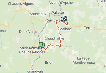
Ruta Senderismo de 14,8 km a descubrir en Occitania, Lozère, Brion. Esta ruta ha sido propuesta por tracegps.
Descripción
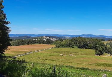
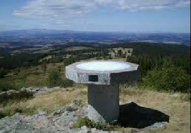
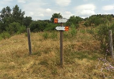
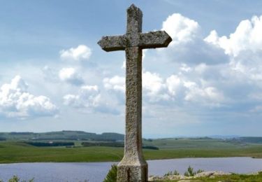
Départ du centre de La Chaldette. On débute par la montée à Reyrac. Passage près de la roche du Cheylaret, du village du même nom où se trouve un panneau expliquant les utilités du mobilier rural. On continue par la forêt jusqu'à Fournels.
Localización
País:
France
Región :
Occitania
Departamento/provincia :
Lozère
Municipio :
Brion
Localidad:
Unknown
Salida:(Dec)
Salida:(UTM)
503549 ; 4957715 (31T) N.
Comentarios
Excursiones cerca
![Excursión Senderismo Brion - Ussels Veyres Luxal - Photo](https://media.geolcdn.com/t/375/260/8a168454-3d88-4877-a192-36f206d6cec4.jpg&format=jpg&maxdim=2)
![Senderismo Senderismo](https://static1.geolcdn.com/sitytour/trail-icons/101.png)
Ussels Veyres Luxal
Senderismo
Medio
Brion,
Occitania,
Lozère,
France
![](/images/other/stat-length.png)
18,4 km | 24 km-effort
4h 55min
![](https://static1.geolcdn.com/siteimages/upload/files/16400158638029165_repeat_loop_refresh_sync_direction_icon.png)
Sí
![Excursión Senderismo Brion - chaldette termes - Photo](https://media.geolcdn.com/t/375/260/2dde7403-42bc-4118-abad-e778b513b691.jpg&format=jpg&maxdim=2)
![Senderismo Senderismo](https://static1.geolcdn.com/sitytour/trail-icons/101.png)
![Excursión Senderismo Brion - La chaldette - Photo](https://media.geolcdn.com/t/375/260/4f2e1336-1b40-4d1d-94fc-05aa2e8e5ce4.jpg&format=jpg&maxdim=2)
![Senderismo Senderismo](https://static1.geolcdn.com/sitytour/trail-icons/101.png)
![Excursión Senderismo Brion - LA CHALDETTE 48 - Le Fau - Le Truc du Cheylaret - Reyrac - Photo](https://media.geolcdn.com/t/375/260/ext.jpg?maxdim=2&url=https%3A%2F%2Fservices.sitytrail.com%2FGeolivesWS%2FDownloadMedia.ashx%3FTrailID%3D443955%26Media%3D20150711173422.jpg)
![Senderismo Senderismo](https://static1.geolcdn.com/sitytour/trail-icons/101.png)
LA CHALDETTE 48 - Le Fau - Le Truc du Cheylaret - Reyrac
Senderismo
Medio
(1)
Brion,
Occitania,
Lozère,
France
![](/images/other/stat-length.png)
10,5 km | 13,9 km-effort
2h 44min
![](https://static1.geolcdn.com/siteimages/upload/files/16400158638029165_repeat_loop_refresh_sync_direction_icon.png)
Sí
![Excursión Senderismo Brion - la chaldette - termes - Photo](https://media.geolcdn.com/t/375/260/10974816-103e-4962-8997-c049dab312fc.jpg&format=jpg&maxdim=2)
![Senderismo Senderismo](https://static1.geolcdn.com/sitytour/trail-icons/101.png)
la chaldette - termes
Senderismo
Medio
Brion,
Occitania,
Lozère,
France
![](/images/other/stat-length.png)
26 km | 35 km-effort
5h 57min
![](https://static1.geolcdn.com/siteimages/upload/files/16400158638029165_repeat_loop_refresh_sync_direction_icon.png)
No
![Excursión Senderismo Deux-Verges - Le Puy de la Tuile - Photo](https://media.geolcdn.com/t/375/260/8c8e0d8f-973f-4cd5-97ab-09ffcd850d61.jpg&format=jpg&maxdim=2)
![Senderismo Senderismo](https://static1.geolcdn.com/sitytour/trail-icons/101.png)
Le Puy de la Tuile
Senderismo
Medio
Deux-Verges,
Auvergne-Rhône-Alpes,
Cantal,
France
![](/images/other/stat-length.png)
8,9 km | 12,5 km-effort
3h 0min
![](https://static1.geolcdn.com/siteimages/upload/files/16400158638029165_repeat_loop_refresh_sync_direction_icon.png)
Sí
![Excursión Senderismo Brion - la chaldette - termes - Photo](https://media.geolcdn.com/t/375/260/ext.jpg?maxdim=2&url=https%3A%2F%2Fservices.sitytrail.com%2FGeolivesWS%2FDownloadMedia.ashx%3FTrailID%3D447033%26Media%3Dfix__20150718125204.jpg)
![Senderismo Senderismo](https://static1.geolcdn.com/sitytour/trail-icons/101.png)
la chaldette - termes
Senderismo
Muy fácil
Brion,
Occitania,
Lozère,
France
![](/images/other/stat-length.png)
29 km | 39 km-effort
7h 1min
![](https://static1.geolcdn.com/siteimages/upload/files/16400158638029165_repeat_loop_refresh_sync_direction_icon.png)
No
![Senderismo Senderismo](https://static1.geolcdn.com/sitytour/trail-icons/101.png)
Jeudi 9 mai
Senderismo
Muy difícil
Brion,
Occitania,
Lozère,
France
![](/images/other/stat-length.png)
19 km | 24 km-effort
5h 27min
![](https://static1.geolcdn.com/siteimages/upload/files/16400158638029165_repeat_loop_refresh_sync_direction_icon.png)
No
![Excursión Senderismo Brion - Le Puech de Brion - Photo](https://media.geolcdn.com/t/375/260/ext.jpg?maxdim=2&url=https%3A%2F%2Fstatic1.geolcdn.com%2Fsiteimages%2Fupload%2Ffiles%2F1553511878bg_sport_marche.png)
![Senderismo Senderismo](https://static1.geolcdn.com/sitytour/trail-icons/101.png)
Le Puech de Brion
Senderismo
Fácil
Brion,
Occitania,
Lozère,
France
![](/images/other/stat-length.png)
7,4 km | 10,1 km-effort
1h 56min
![](https://static1.geolcdn.com/siteimages/upload/files/16400158638029165_repeat_loop_refresh_sync_direction_icon.png)
Sí