![](/images/other/stat-length.png)
![Excursión Senderismo Val-Cenis - Mont Froid - Lanslebourg-Mont-Cenis - Photo](https://media.geolcdn.com/t/1900/400/ext.pjpeg?maxdim=2&url=https%3A%2F%2Fservices.sitytrail.com%2FGeolivesWS%2FDownloadMedia.ashx%3FTrailID%3D172808%26Media%3D14238_5.jpg)
Mont Froid - Lanslebourg-Mont-Cenis
tracegps
Usuario
![Longitud](/images/other/stat-length.png)
![Altitud máxima](https://static1.geolcdn.com/siteimages/upload/files/1508320355ic_sort_altitude_max_24dp.png)
![Desnivel positivo](https://static1.geolcdn.com/siteimages/upload/files/1508320355ic_sort_den_pos_24dp.png)
![Km-Effort](/images/other/stat-length.png)
![Altitud mínima](https://static1.geolcdn.com/siteimages/upload/files/1508320355ic_sort_altitude_min_24dp.png)
![Desnivel negativo](https://static1.geolcdn.com/siteimages/upload/files/1508320355ic_sort_den_neg_24dp.png)
![Boucle](https://static1.geolcdn.com/siteimages/upload/files/16400158638029165_repeat_loop_refresh_sync_direction_icon.png)
![Senderismo](https://static1.geolcdn.com/sitytour/trail-icons/101.png)
4h30
Dificultad : Difícil
![Escanee este código QR para abrir la excursión en la aplicación SityTrail](https://capi.geolives.com/qq0zvz2zws4bq2lad0pu/sitytour/trails/172808/qr.png?size=200)
Aplicación GPS de excursión GRATIS
A propósito
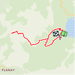
Ruta Senderismo de 16,4 km a descubrir en Auvergne-Rhône-Alpes, Saboya, Val-Cenis. Esta ruta ha sido propuesta por tracegps.
Descripción
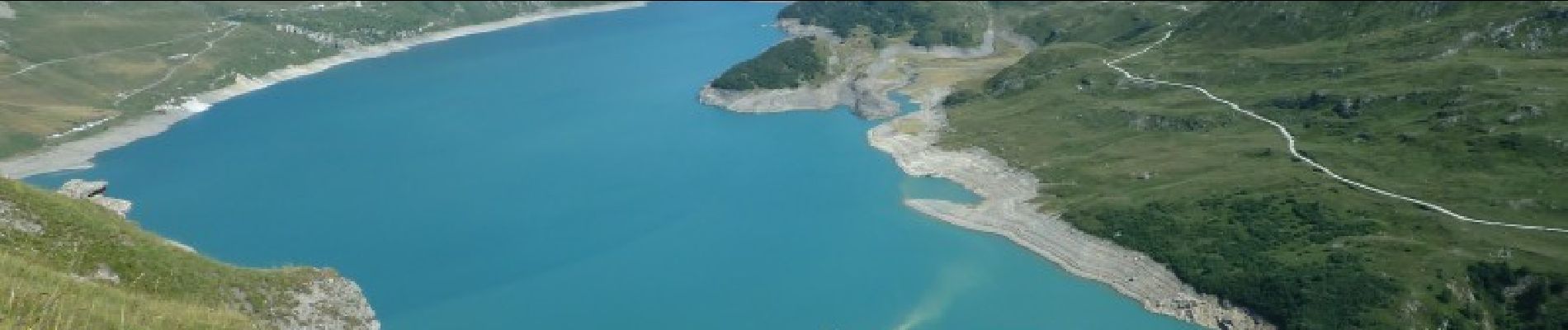
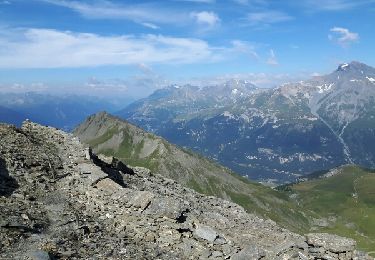
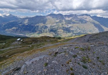
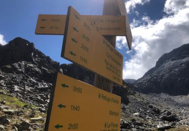
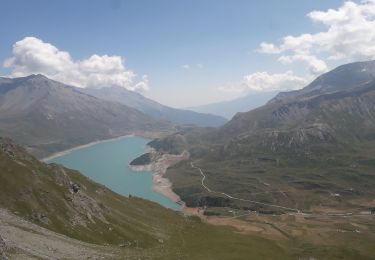
La haute-Maurienne, c’est aussi l’histoire militaire des pierres fortes. Le Mont Froid en fait partie, d’autant plus qu’il s’agit d’une construction française, réputée pour être la plus haute. Si les ruines qui demeurent aujourd’hui ne renseignement que peu sur le génie militaire, elles demeurent un indicateur de premier ordre dans le choix des randonnées : là où il y a une place forte d’altitude il y a souvent un superbe panorama… C’est précisément le cas du Mont Froid (2822 m), qui révèle à la fois une magnifique vigie sur le secteur du Mont Cenis et une vue plongeante sur Modane ou Sollières. Outre la vue, cette randonnée, même si sa longueur n’est pas à négliger, offre un paysage verdoyant aux croupes arrondies et apaisantes, de quoi se changer du caractère purement montagnard de certains autres itinéraires aux mêmes mensurations. Autre avantage, elle se déroule entièrement sur un bon sentier, la rendant ainsi accessible au plus grand nombre. La trace proposée part de la Chapelle Ste- Barthélémy. Il est possible de partir du refuge du Petit mont Cenis pour faire plus court. Afin de réaliser un semblant de boucle, le retour forme un crochet dont l’avantage est de découvrir petit à petit un splendide panorama en balcon sur le lac. La partie du sentier en pointillé sur la carte IGN ne pose aucun souci. Pour l’orientation, il n’y a rien de particulier à signaler, sinon suivre les chemins.
Localización
Comentarios
Excursiones cerca
![Excursión Senderismo Val-Cenis - signal du Petit Mont-Cenis Cenis - Photo](https://media.geolcdn.com/t/375/260/ext.jpg?maxdim=2&url=https%3A%2F%2Fservices.sitytrail.com%2FGeolivesWS%2FDownloadMedia.ashx%3FTrailID%3D615956%26Media%3Dfix__20160817102723.jpg)
![Senderismo Senderismo](https://static1.geolcdn.com/sitytour/trail-icons/101.png)
Senderismo
![](/images/other/stat-length.png)
![](https://static1.geolcdn.com/siteimages/upload/files/16400158638029165_repeat_loop_refresh_sync_direction_icon.png)
![Excursión Senderismo Val-Cenis - Lac de Savinne - Photo](https://media.geolcdn.com/t/375/260/ext.jpg?maxdim=2&url=https%3A%2F%2Fstatic1.geolcdn.com%2Fsiteimages%2Fupload%2Ffiles%2F1553511878bg_sport_marche.png)
![Senderismo Senderismo](https://static1.geolcdn.com/sitytour/trail-icons/101.png)
Senderismo
![](/images/other/stat-length.png)
![](https://static1.geolcdn.com/siteimages/upload/files/16400158638029165_repeat_loop_refresh_sync_direction_icon.png)
![Excursión sport Val-Cenis - L’ancien fort de la Turra - Photo](https://media.geolcdn.com/t/375/260/2f372af5-3d13-4f3d-be22-d2d73efaca61.jpg&format=jpg&maxdim=2)
sport
![](/images/other/stat-length.png)
![](https://static1.geolcdn.com/siteimages/upload/files/16400158638029165_repeat_loop_refresh_sync_direction_icon.png)
![Excursión Senderismo Val-Cenis - Montcenis lac fort de la Tura - Photo](https://media.geolcdn.com/t/375/260/03903eba-f11b-41f0-bc93-d99cacc6c53d.jpg&format=jpg&maxdim=2)
![Senderismo Senderismo](https://static1.geolcdn.com/sitytour/trail-icons/101.png)
Senderismo
![](/images/other/stat-length.png)
![](https://static1.geolcdn.com/siteimages/upload/files/16400158638029165_repeat_loop_refresh_sync_direction_icon.png)
![Excursión Senderismo Val-Cenis - Col de la Met et Lac de l'Arcelle au départ du télésiège de Solert - Photo](https://media.geolcdn.com/t/375/260/fc51f4c9-cabd-4b7a-83d2-604413b6e3fa.jpg&format=jpg&maxdim=2)
![Senderismo Senderismo](https://static1.geolcdn.com/sitytour/trail-icons/101.png)
Senderismo
![](/images/other/stat-length.png)
![](https://static1.geolcdn.com/siteimages/upload/files/16400158638029165_repeat_loop_refresh_sync_direction_icon.png)
![Excursión Senderismo Val-Cenis - Refuge du petit Mont-Cenis - Col de Bellecombe - Photo](https://media.geolcdn.com/t/375/260/6ef1a6b7-2407-4d68-aa00-60607ba7429d.jpg&format=jpg&maxdim=2)
![Senderismo Senderismo](https://static1.geolcdn.com/sitytour/trail-icons/101.png)
Senderismo
![](/images/other/stat-length.png)
![](https://static1.geolcdn.com/siteimages/upload/files/16400158638029165_repeat_loop_refresh_sync_direction_icon.png)
![Excursión Senderismo Val-Cenis - Le Fort de la Turra - Photo](https://media.geolcdn.com/t/375/260/fb7e4b15-499e-46a6-93e3-9848cd5c0804.jpg&format=jpg&maxdim=2)
![Senderismo Senderismo](https://static1.geolcdn.com/sitytour/trail-icons/101.png)
Senderismo
![](/images/other/stat-length.png)
![](https://static1.geolcdn.com/siteimages/upload/files/16400158638029165_repeat_loop_refresh_sync_direction_icon.png)
![Excursión Senderismo Val-Cenis - Col agnel puis Lac d'Ambin Bramans - Photo](https://media.geolcdn.com/t/375/260/1745d82d-7eda-48ff-b6de-c3bab13e3684.jpg&format=jpg&maxdim=2)
![Senderismo Senderismo](https://static1.geolcdn.com/sitytour/trail-icons/101.png)
Senderismo
![](/images/other/stat-length.png)
![](https://static1.geolcdn.com/siteimages/upload/files/16400158638029165_repeat_loop_refresh_sync_direction_icon.png)
![Excursión Senderismo Val-Cenis - fort de la Turra - col de la Beccia - Photo](https://media.geolcdn.com/t/375/260/519bc2cf-9575-4c95-8b89-a32fb03a43b6.jpg&format=jpg&maxdim=2)
![Senderismo Senderismo](https://static1.geolcdn.com/sitytour/trail-icons/101.png)
Senderismo
![](/images/other/stat-length.png)
![](https://static1.geolcdn.com/siteimages/upload/files/16400158638029165_repeat_loop_refresh_sync_direction_icon.png)