![](/images/other/stat-length.png)
![Excursión Senderismo Eyzahut - Tour du Pays de Dieulefit - Eyzahut à Le Poët-Laval - Photo](https://media.geolcdn.com/t/1900/400/ext.pjpeg?maxdim=2&url=https%3A%2F%2Fservices.sitytrail.com%2FGeolivesWS%2FDownloadMedia.ashx%3FTrailID%3D172802%26Media%3D14232_5.jpg)
Tour du Pays de Dieulefit - Eyzahut à Le Poët-Laval
tracegps
Usuario
![Longitud](/images/other/stat-length.png)
![Altitud máxima](https://static1.geolcdn.com/siteimages/upload/files/1508320355ic_sort_altitude_max_24dp.png)
![Desnivel positivo](https://static1.geolcdn.com/siteimages/upload/files/1508320355ic_sort_den_pos_24dp.png)
![Km-Effort](/images/other/stat-length.png)
![Altitud mínima](https://static1.geolcdn.com/siteimages/upload/files/1508320355ic_sort_altitude_min_24dp.png)
![Desnivel negativo](https://static1.geolcdn.com/siteimages/upload/files/1508320355ic_sort_den_neg_24dp.png)
![Boucle](https://static1.geolcdn.com/siteimages/upload/files/16400158638029165_repeat_loop_refresh_sync_direction_icon.png)
![Senderismo](https://static1.geolcdn.com/sitytour/trail-icons/101.png)
2h15
Dificultad : Medio
![Escanee este código QR para abrir la excursión en la aplicación SityTrail](https://capi.geolives.com/qq0zvz2zws4bq2lad0pu/sitytour/trails/172802/qr.png?size=200)
Aplicación GPS de excursión GRATIS
A propósito
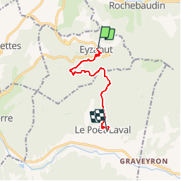
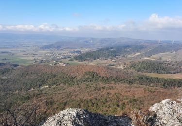
Ruta Senderismo de 7,1 km a descubrir en Auvergne-Rhône-Alpes, Drôme, Eyzahut. Esta ruta ha sido propuesta por tracegps.
Descripción
Neuvième et dernière étape: les 7 kilomètres restant vous font grimper la Montagne du Poët jusqu'à 820m, il ne reste plus qu'à descendre pour rejoindre Poët-Laval. Retrouvez le plan global du circuit sur le site de la Communauté de Communes du pays de Dieulefit.
Localización
Comentarios
Excursiones cerca
![Excursión Senderismo Charols - 2022-10-01_18h01m37_13052196 - Photo](https://media.geolcdn.com/t/375/260/44333c54-0203-4720-b217-7a484d4324d6.jpg&format=jpg&maxdim=2)
![Senderismo Senderismo](https://static1.geolcdn.com/sitytour/trail-icons/101.png)
Senderismo
![](/images/other/stat-length.png)
![](https://static1.geolcdn.com/siteimages/upload/files/16400158638029165_repeat_loop_refresh_sync_direction_icon.png)
![Excursión Senderismo Pont-de-Barret - Pont-de-Barret 7km5 - Photo](https://media.geolcdn.com/t/375/260/bd4539ba-b505-451b-88b8-8a669ff8e607.jpg&format=jpg&maxdim=2)
![Senderismo Senderismo](https://static1.geolcdn.com/sitytour/trail-icons/101.png)
Senderismo
![](/images/other/stat-length.png)
![](https://static1.geolcdn.com/siteimages/upload/files/16400158638029165_repeat_loop_refresh_sync_direction_icon.png)
![Excursión A pie Eyzahut - SityTrail - Boucle 1 - Photo](https://media.geolcdn.com/t/375/260/18dbfece-5a68-4dfb-9f06-5bb6196c6685.jpg&format=jpg&maxdim=2)
![A pie A pie](https://static1.geolcdn.com/sitytour/trail-icons/100.png)
A pie
![](/images/other/stat-length.png)
![](https://static1.geolcdn.com/siteimages/upload/files/16400158638029165_repeat_loop_refresh_sync_direction_icon.png)
![Excursión Senderismo Dieulefit - 26 dieulefit chap st Maurice vitrouilleres - Photo](https://media.geolcdn.com/t/375/260/9032ba92-359b-417c-8863-3a326ab807ba.jpg&format=jpg&maxdim=2)
![Senderismo Senderismo](https://static1.geolcdn.com/sitytour/trail-icons/101.png)
Senderismo
![](/images/other/stat-length.png)
![](https://static1.geolcdn.com/siteimages/upload/files/16400158638029165_repeat_loop_refresh_sync_direction_icon.png)
![Excursión Senderismo Le Poët-Laval - Poët-Laval Les vitrouilléres (La Dame Blanche) 9km. - Photo](https://media.geolcdn.com/t/375/260/aa6f7aee-41bd-433a-b904-1eda7a964ff6.jpg&format=jpg&maxdim=2)
![Senderismo Senderismo](https://static1.geolcdn.com/sitytour/trail-icons/101.png)
Senderismo
![](/images/other/stat-length.png)
![](https://static1.geolcdn.com/siteimages/upload/files/16400158638029165_repeat_loop_refresh_sync_direction_icon.png)
![Excursión Senderismo Le Poët-Laval - Le Poet Laval : Le Trou du Furet 6km5 - Photo](https://media.geolcdn.com/t/375/260/e856c3d2-cc59-44f2-9430-12ee63613b6b.jpg&format=jpg&maxdim=2)
![Senderismo Senderismo](https://static1.geolcdn.com/sitytour/trail-icons/101.png)
Senderismo
![](/images/other/stat-length.png)
![](https://static1.geolcdn.com/siteimages/upload/files/16400158638029165_repeat_loop_refresh_sync_direction_icon.png)
![Excursión Senderismo Rochebaudin - Rochebaudin-Trou du Furet-Serre Gros 16km - Photo](https://media.geolcdn.com/t/375/260/dc7160ec-c951-47bb-8de8-e15fab760352.jpg&format=jpg&maxdim=2)
![Senderismo Senderismo](https://static1.geolcdn.com/sitytour/trail-icons/101.png)
Senderismo
![](/images/other/stat-length.png)
![](https://static1.geolcdn.com/siteimages/upload/files/16400158638029165_repeat_loop_refresh_sync_direction_icon.png)
![Excursión Senderismo Dieulefit - 2022-09-03_11h50m30_Chapelle St Maurice 10km.gpx (3).xml - Photo](https://media.geolcdn.com/t/375/260/70a2cb51-e6fc-4007-ba36-e4a050e05f72.jpg&format=jpg&maxdim=2)
![Senderismo Senderismo](https://static1.geolcdn.com/sitytour/trail-icons/101.png)
Senderismo
![](/images/other/stat-length.png)
![](https://static1.geolcdn.com/siteimages/upload/files/16400158638029165_repeat_loop_refresh_sync_direction_icon.png)
![Excursión Senderismo Manas - SityTrail - Puy St Martin La Pigne-Saudon 8,5km - Photo](https://media.geolcdn.com/t/375/260/aabcc6ea-3a3d-45fe-9e4a-f6a7c1e309c7.jpg&format=jpg&maxdim=2)
![Senderismo Senderismo](https://static1.geolcdn.com/sitytour/trail-icons/101.png)
Senderismo
![](/images/other/stat-length.png)
![](https://static1.geolcdn.com/siteimages/upload/files/16400158638029165_repeat_loop_refresh_sync_direction_icon.png)