![](/images/other/stat-length.png)
![Excursión Senderismo Saint-Colomban-des-Villards - Cols de la Croix et du Sambuis - Photo](https://media.geolcdn.com/t/1900/400/ext.pjpeg?maxdim=2&url=https%3A%2F%2Fservices.sitytrail.com%2FGeolivesWS%2FDownloadMedia.ashx%3FTrailID%3D172739%26Media%3D14139_5.jpg)
Cols de la Croix et du Sambuis
tracegps
Usuario
![Longitud](/images/other/stat-length.png)
![Altitud máxima](https://static1.geolcdn.com/siteimages/upload/files/1508320355ic_sort_altitude_max_24dp.png)
![Desnivel positivo](https://static1.geolcdn.com/siteimages/upload/files/1508320355ic_sort_den_pos_24dp.png)
![Km-Effort](/images/other/stat-length.png)
![Altitud mínima](https://static1.geolcdn.com/siteimages/upload/files/1508320355ic_sort_altitude_min_24dp.png)
![Desnivel negativo](https://static1.geolcdn.com/siteimages/upload/files/1508320355ic_sort_den_neg_24dp.png)
![Boucle](https://static1.geolcdn.com/siteimages/upload/files/16400158638029165_repeat_loop_refresh_sync_direction_icon.png)
![Senderismo](https://static1.geolcdn.com/sitytour/trail-icons/101.png)
4h00
Dificultad : Difícil
![Escanee este código QR para abrir la excursión en la aplicación SityTrail](https://capi.geolives.com/qq0zvz2zws4bq2lad0pu/sitytour/trails/172739/qr.png?size=200)
Aplicación GPS de excursión GRATIS
A propósito
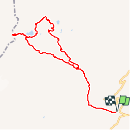
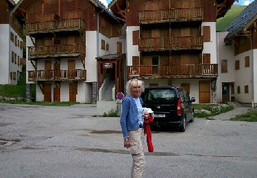
Ruta Senderismo de 10,8 km a descubrir en Auvergne-Rhône-Alpes, Saboya, Saint-Colomban-des-Villards. Esta ruta ha sido propuesta por tracegps.
Descripción
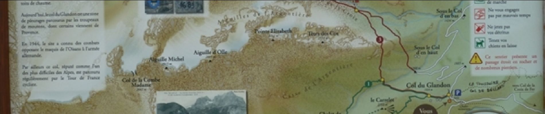
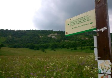
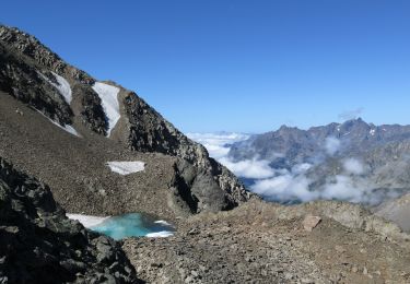
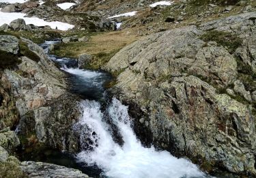
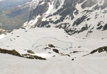
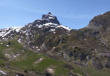
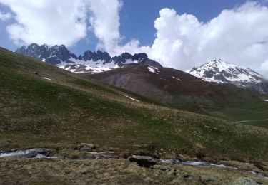
La montée au col de la Croix (en aller-retour – 9kms / 800 de D ) est une grande classique pour marcheur, sans difficulté à l’exception de la raide remontée du (et dans !) le torrent vers l’altitude 2280 m. De bonnes chaussures imperméables ne saurait être que conseillées mais ça ne pose techniquement pas de problème. Depuis le parking du col du Glandon, le sentier est bien marqué, indiqué (et fréquenté... ) Après la remontée de ce qui est quasiment une cascade on arrive dans une sorte de cuvette où demeure un névé. Soit le contourner par la droite, soit -plus simple- le traverser en partant légèrement sur la droite. On retrouve dans les deux cas le chemin du ressaut final qui mène au lac. Du lac, il serait dommage de ne pas poursuivre jusqu’au col, avec ses marques de l’ancienne frontière avec la Savoie, sa vue plongeante sur les massifs de Belledonne et de la Chartreuse. Un bouquetin nous y regardait d’un peu plus haut. Plutôt que de redescendre par le même chemin, on pourra suivre la trace qui se laisse deviner au milieu de quelques cairns à l’est du lac de la Croix pour rejoindre le col du Sambuis, beaucoup plus tranquille, puis redescendre en reprenant la trace qui monte à la cime du Sambuis (en pointillés sur le panneau d’information du parking) à l’extrémité sud-est petit lac en contre bas du col. Il convient d’être bien attentif aux cairns dans quelques pierriers. On rejoint le sentier principal et sa foule vers l’alt. 2045m.
Localización
Comentarios
Excursiones cerca
![Excursión Senderismo Saint-Colomban-des-Villards - Lac de l'âne départ pont du Rieu-claret - Photo](https://media.geolcdn.com/t/375/260/da43fabe-f484-4e32-b936-8fd9ca7d3840.jpg&format=jpg&maxdim=2)
![Senderismo Senderismo](https://static1.geolcdn.com/sitytour/trail-icons/101.png)
Senderismo
![](/images/other/stat-length.png)
![](https://static1.geolcdn.com/siteimages/upload/files/16400158638029165_repeat_loop_refresh_sync_direction_icon.png)
![Excursión Senderismo Saint-Sorlin-d'Arves - Les Prés Plans - Photo](https://media.geolcdn.com/t/375/260/ext.jpg?maxdim=2&url=https%3A%2F%2Fservices.sitytrail.com%2FGeolivesWS%2FDownloadMedia.ashx%3FTrailID%3D319006%26Media%3Dfix__20140626140927.jpg)
![Senderismo Senderismo](https://static1.geolcdn.com/sitytour/trail-icons/101.png)
Senderismo
![](/images/other/stat-length.png)
![](https://static1.geolcdn.com/siteimages/upload/files/16400158638029165_repeat_loop_refresh_sync_direction_icon.png)
![Excursión Marcha nórdica Saint-Sorlin-d'Arves - La Balme - Photo](https://media.geolcdn.com/t/375/260/ext.jpg?maxdim=2&url=https%3A%2F%2Fservices.sitytrail.com%2FGeolivesWS%2FDownloadMedia.ashx%3FTrailID%3D319005%26Media%3Dfix__20140624124356.jpg)
![Marcha nórdica Marcha nórdica](https://static1.geolcdn.com/sitytour/trail-icons/102.png)
Marcha nórdica
![](/images/other/stat-length.png)
![](https://static1.geolcdn.com/siteimages/upload/files/16400158638029165_repeat_loop_refresh_sync_direction_icon.png)
![Senderismo Senderismo](https://static1.geolcdn.com/sitytour/trail-icons/101.png)
Senderismo
![](/images/other/stat-length.png)
![](https://static1.geolcdn.com/siteimages/upload/files/16400158638029165_repeat_loop_refresh_sync_direction_icon.png)
![Excursión Esquí de fondo Saint-Colomban-des-Villards - col de la combe, sous aiguille d'olle - Photo](https://media.geolcdn.com/t/375/260/c1d7429c-86e7-4e29-ae26-be2b5cfcf032.jpg&format=jpg&maxdim=2)
![Esquí de fondo Esquí de fondo](https://static1.geolcdn.com/sitytour/trail-icons/503.png)
Esquí de fondo
![](/images/other/stat-length.png)
![](https://static1.geolcdn.com/siteimages/upload/files/16400158638029165_repeat_loop_refresh_sync_direction_icon.png)
![Excursión Esquí de fondo Saint-Colomban-des-Villards - Sous la selle du Puy gris - Photo](https://media.geolcdn.com/t/375/260/baabb621-fdb8-4d11-983c-fff2e275ca53.jpg&format=jpg&maxdim=2)
![Esquí de fondo Esquí de fondo](https://static1.geolcdn.com/sitytour/trail-icons/503.png)
Esquí de fondo
![](/images/other/stat-length.png)
![](https://static1.geolcdn.com/siteimages/upload/files/16400158638029165_repeat_loop_refresh_sync_direction_icon.png)
![Excursión Esquí de fondo Saint-Colomban-des-Villards - Bec d'arguille - Photo](https://media.geolcdn.com/t/375/260/04f722e3-8045-48e3-9fe8-9ee83d084610.jpg&format=jpg&maxdim=2)
![Esquí de fondo Esquí de fondo](https://static1.geolcdn.com/sitytour/trail-icons/503.png)
Esquí de fondo
![](/images/other/stat-length.png)
![](https://static1.geolcdn.com/siteimages/upload/files/16400158638029165_repeat_loop_refresh_sync_direction_icon.png)
![Excursión Esquí de fondo Saint-Colomban-des-Villards - Cime du Sambuy et col de la croix - Photo](https://media.geolcdn.com/t/375/260/6bf938f5-7e9f-4863-acb7-59f7ca62c43e.jpg&format=jpg&maxdim=2)
![Esquí de fondo Esquí de fondo](https://static1.geolcdn.com/sitytour/trail-icons/503.png)
Esquí de fondo
![](/images/other/stat-length.png)
![](https://static1.geolcdn.com/siteimages/upload/files/16400158638029165_repeat_loop_refresh_sync_direction_icon.png)
![Excursión Esquí de fondo Saint-Colomban-des-Villards - Aiguille de Laysse, et Dôme de la Cochette descente Ouest - Photo](https://media.geolcdn.com/t/375/260/3d336035-8ca4-4b8b-b9fd-38b21f0e429c.jpg&format=jpg&maxdim=2)
![Esquí de fondo Esquí de fondo](https://static1.geolcdn.com/sitytour/trail-icons/503.png)
Esquí de fondo
![](/images/other/stat-length.png)
![](https://static1.geolcdn.com/siteimages/upload/files/16400158638029165_repeat_loop_refresh_sync_direction_icon.png)