![](/images/other/stat-length.png)
![Excursión Senderismo Morzine - Les Hauts-Forts, Col de l'Encarnette, 2359m - Photo](https://media.geolcdn.com/t/1900/400/ext.pjpeg?maxdim=2&url=https%3A%2F%2Fservices.sitytrail.com%2FGeolivesWS%2FDownloadMedia.ashx%3FTrailID%3D172633%26Media%3D14002_1.jpg)
Les Hauts-Forts, Col de l'Encarnette, 2359m
tracegps
Usuario
![Longitud](/images/other/stat-length.png)
![Altitud máxima](https://static1.geolcdn.com/siteimages/upload/files/1508320355ic_sort_altitude_max_24dp.png)
![Desnivel positivo](https://static1.geolcdn.com/siteimages/upload/files/1508320355ic_sort_den_pos_24dp.png)
![Km-Effort](/images/other/stat-length.png)
![Altitud mínima](https://static1.geolcdn.com/siteimages/upload/files/1508320355ic_sort_altitude_min_24dp.png)
![Desnivel negativo](https://static1.geolcdn.com/siteimages/upload/files/1508320355ic_sort_den_neg_24dp.png)
![Boucle](https://static1.geolcdn.com/siteimages/upload/files/16400158638029165_repeat_loop_refresh_sync_direction_icon.png)
![Senderismo](https://static1.geolcdn.com/sitytour/trail-icons/101.png)
7h30
Dificultad : Difícil
![Escanee este código QR para abrir la excursión en la aplicación SityTrail](https://capi.geolives.com/qq0zvz2zws4bq2lad0pu/sitytour/trails/172633/qr.png?size=200)
Aplicación GPS de excursión GRATIS
A propósito
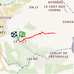
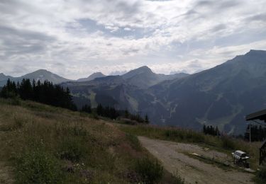
Ruta Senderismo de 9,1 km a descubrir en Auvergne-Rhône-Alpes, Alta Saboya, Morzine. Esta ruta ha sido propuesta por tracegps.
Descripción
Chablais. Le paysage de la randonnée soutenue et plutôt sauvage, dans l'environnement des stations de Morzine et d'Avoriaz, ne souffre pas de la proximité des remontées mécanique. Le départ est fixé au Crêt, petit hameau de Morzine. Dans la forêt, la montée est rude par Bramaturtaz pour déboucher dans l'alpage du Plan de Zore. L'ascension plus raisonnable du Col de Pic à Talon débouche sur l'arête des Hauts-Forts qui par le Col des Chalettes et la traversée exposée du Col de l'Encarnette va conduire jusqu'au sommet. Le retour se fait par le même itinéraire. Description complète sur sentier-nature.com : Les Hauts-Forts, Col de l'Encarnette, 2359m Avertissement [Franchissement 1/3 ; Exposition 2/3 ; Pénibilité 2/3]. Certains passages de cet itinéraire de montagne sont escarpés et/ou très exposés, il est déconseillé aux enfants non accompagnés et aux personnes sujettes au vertige. Pour votre sécurité, nous vous invitons à respecter les règles suivantes : être bien chaussé, ne pas s'engager par mauvais temps, ne pas s'écarter de l'itinéraire ni des sentiers.
Localización
Comentarios
Excursiones cerca
![Excursión Senderismo Morzine - d'Avoriaz aux Mines d'or par le col du Fornet et le col de Cou - Photo](https://media.geolcdn.com/t/375/260/ext.jpg?maxdim=2&url=https%3A%2F%2Fservices.sitytrail.com%2FGeolivesWS%2FDownloadMedia.ashx%3FTrailID%3D804915%26Media%3D20170807144141.jpg)
![Senderismo Senderismo](https://static1.geolcdn.com/sitytour/trail-icons/101.png)
Senderismo
![](/images/other/stat-length.png)
![](https://static1.geolcdn.com/siteimages/upload/files/16400158638029165_repeat_loop_refresh_sync_direction_icon.png)
![Excursión Senderismo Morzine - balade des crêtes : Avoriaz . belvédère du lac de Montriond . croix des combes . Avoriaz - Photo](https://media.geolcdn.com/t/375/260/f4d442e1-fe36-4b17-a99a-0349118a63ec.jpg&format=jpg&maxdim=2)
![Senderismo Senderismo](https://static1.geolcdn.com/sitytour/trail-icons/101.png)
Senderismo
![](/images/other/stat-length.png)
![](https://static1.geolcdn.com/siteimages/upload/files/16400158638029165_repeat_loop_refresh_sync_direction_icon.png)
![Excursión Senderismo Verchaix - col de joux plane - Photo](https://media.geolcdn.com/t/375/260/f5f22de2-b8d8-4ec7-857b-352656491634.jpg&format=jpg&maxdim=2)
![Senderismo Senderismo](https://static1.geolcdn.com/sitytour/trail-icons/101.png)
Senderismo
![](/images/other/stat-length.png)
![](https://static1.geolcdn.com/siteimages/upload/files/16400158638029165_repeat_loop_refresh_sync_direction_icon.png)
![Excursión Senderismo Samoëns - La tête de Bostan - Photo](https://media.geolcdn.com/t/375/260/c42830f7-a262-4abd-8f00-d269896222b2.jpg&format=jpg&maxdim=2)
![Senderismo Senderismo](https://static1.geolcdn.com/sitytour/trail-icons/101.png)
Senderismo
![](/images/other/stat-length.png)
![](https://static1.geolcdn.com/siteimages/upload/files/16400158638029165_repeat_loop_refresh_sync_direction_icon.png)
![Excursión Senderismo Morzine - Arête de super Morzine - Photo](https://media.geolcdn.com/t/375/260/2f97f0ba-3061-4f5a-be28-27baf6b86989.jpg&format=jpg&maxdim=2)
![Senderismo Senderismo](https://static1.geolcdn.com/sitytour/trail-icons/101.png)
Senderismo
![](/images/other/stat-length.png)
![](https://static1.geolcdn.com/siteimages/upload/files/16400158638029165_repeat_loop_refresh_sync_direction_icon.png)
![Excursión Senderismo Morzine - morzine la cime de Nyon - Photo](https://media.geolcdn.com/t/375/260/9cf9770f-202e-49ec-8ef9-b204d4b5c2e6.jpg&format=jpg&maxdim=2)
![Senderismo Senderismo](https://static1.geolcdn.com/sitytour/trail-icons/101.png)
Senderismo
![](/images/other/stat-length.png)
![](https://static1.geolcdn.com/siteimages/upload/files/16400158638029165_repeat_loop_refresh_sync_direction_icon.png)
![Excursión Senderismo Les Gets - morzine col du mont chery - Photo](https://media.geolcdn.com/t/375/260/15b7d016-07a2-4cc1-9bc8-ccf4c00982d5.jpg&format=jpg&maxdim=2)
![Senderismo Senderismo](https://static1.geolcdn.com/sitytour/trail-icons/101.png)
Senderismo
![](/images/other/stat-length.png)
![](https://static1.geolcdn.com/siteimages/upload/files/16400158638029165_repeat_loop_refresh_sync_direction_icon.png)
![Excursión Marcha nórdica Morzine - Tour pleney - Photo](https://media.geolcdn.com/t/375/260/53078271-973f-4f11-9197-b26f9521b4b9.jpg&format=jpg&maxdim=2)
![Marcha nórdica Marcha nórdica](https://static1.geolcdn.com/sitytour/trail-icons/102.png)
Marcha nórdica
![](/images/other/stat-length.png)
![](https://static1.geolcdn.com/siteimages/upload/files/16400158638029165_repeat_loop_refresh_sync_direction_icon.png)
![Excursión Senderismo Morzine - 74-Avoriaz-cretes-belvedere-10km-360 - Photo](https://media.geolcdn.com/t/375/260/25538cc4-cfbb-49c4-b268-c30134a766c6.jpg&format=jpg&maxdim=2)
![Senderismo Senderismo](https://static1.geolcdn.com/sitytour/trail-icons/101.png)
Senderismo
![](/images/other/stat-length.png)
![](https://static1.geolcdn.com/siteimages/upload/files/16400158638029165_repeat_loop_refresh_sync_direction_icon.png)
Col de cou