![](/images/other/stat-length.png)
![Excursión Senderismo Draillant - Le Mont Forchat, 1539m - Habère Lullin - Photo](https://media.geolcdn.com/t/1900/400/ext.pjpeg?maxdim=2&url=https%3A%2F%2Fservices.sitytrail.com%2FGeolivesWS%2FDownloadMedia.ashx%3FTrailID%3D172431%26Media%3D13776_1.jpg)
Le Mont Forchat, 1539m - Habère Lullin
tracegps
Usuario
![Longitud](/images/other/stat-length.png)
![Altitud máxima](https://static1.geolcdn.com/siteimages/upload/files/1508320355ic_sort_altitude_max_24dp.png)
![Desnivel positivo](https://static1.geolcdn.com/siteimages/upload/files/1508320355ic_sort_den_pos_24dp.png)
![Km-Effort](/images/other/stat-length.png)
![Altitud mínima](https://static1.geolcdn.com/siteimages/upload/files/1508320355ic_sort_altitude_min_24dp.png)
![Desnivel negativo](https://static1.geolcdn.com/siteimages/upload/files/1508320355ic_sort_den_neg_24dp.png)
![Boucle](https://static1.geolcdn.com/siteimages/upload/files/16400158638029165_repeat_loop_refresh_sync_direction_icon.png)
![Senderismo](https://static1.geolcdn.com/sitytour/trail-icons/101.png)
3h15
Dificultad : Medio
![Escanee este código QR para abrir la excursión en la aplicación SityTrail](https://capi.geolives.com/qq0zvz2zws4bq2lad0pu/sitytour/trails/172431/qr.png?size=200)
Aplicación GPS de excursión GRATIS
A propósito
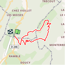
Ruta Senderismo de 7,4 km a descubrir en Auvergne-Rhône-Alpes, Alta Saboya, Draillant. Esta ruta ha sido propuesta por tracegps.
Descripción
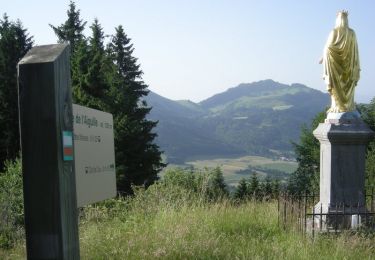
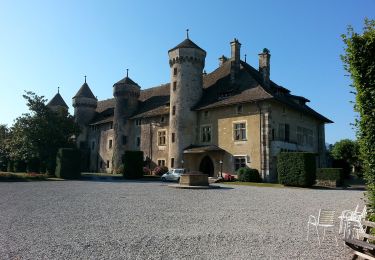
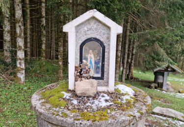
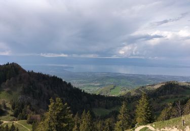
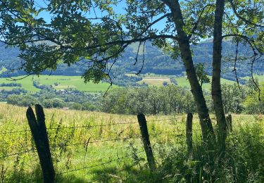
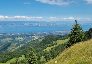
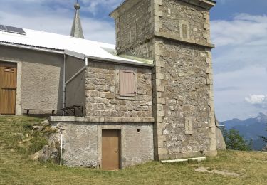
Chablais. Point de vue remarquable pour son étendue, le Mont Forchat permet une randonnée courte et facile au départ du Col des Moises. Un bon chemin en lacets, monte à l'ombre de la forêt suivre les clairières d'une crête issue du sommet de Très-la-Paraz. Une courte traversée mène ensuite au Col de l'Encrenaz au pied du versant Ouest du Mont Forchat. Un raidillon dépose au pied de la statue de Saint François-de-Salle érigée au sommet. Le panorama grandiose s'étend sur 360° du Jura au Chablais en passant par le Lac Léman, le Mont Blanc au loin, les Aravis, etc. La descente agréable passe près du hameau de Très-le-Mont, pour trouver dans l'alpage un sentier aventureux à travers les Moises, qui rejoint l'itinéraire de montée à une dizaine de minutes du point de départ. Description complète sur sentier-nature.com : Le Mont Forchat, 1539m Avertissement [Pénibilité 1/3]. Certains passages de cet itinéraire de montagne sont escarpés et/ou très exposés, il est déconseillé aux enfants non accompagnés et aux personnes sujettes au vertige. Pour votre sécurité, nous vous invitons à respecter les règles suivantes : être bien chaussé, ne pas s'engager par mauvais temps, ne pas s'écarter de l'itinéraire ni des sentiers.
Localización
Comentarios
Excursiones cerca
![Excursión Senderismo Habère-Poche - Mont Forchat - Habère Poche - Ramble - Photo](https://media.geolcdn.com/t/375/260/ext.jpg?maxdim=2&url=https%3A%2F%2Fservices.sitytrail.com%2FGeolivesWS%2FDownloadMedia.ashx%3FTrailID%3D172416%26Media%3D13761_5.jpg)
![Senderismo Senderismo](https://static1.geolcdn.com/sitytour/trail-icons/101.png)
Senderismo
![](/images/other/stat-length.png)
![](https://static1.geolcdn.com/siteimages/upload/files/16400158638029165_repeat_loop_refresh_sync_direction_icon.png)
![Excursión Senderismo Habère-Poche - Le mont forchat - Photo](https://media.geolcdn.com/t/375/260/d1f9b614-5785-4475-8cf0-6084676ee891.jpg&format=jpg&maxdim=2)
![Senderismo Senderismo](https://static1.geolcdn.com/sitytour/trail-icons/101.png)
Senderismo
![](/images/other/stat-length.png)
![](https://static1.geolcdn.com/siteimages/upload/files/16400158638029165_repeat_loop_refresh_sync_direction_icon.png)
![Excursión Moto Orcier - GTA 2018 - ETAPE 11 - Photo](https://media.geolcdn.com/t/375/260/2a7aaed3-856b-42de-90e6-a00ec91059f1.jpg&format=jpg&maxdim=2)
![Moto Moto](https://static1.geolcdn.com/sitytour/trail-icons/402.png)
Moto
![](/images/other/stat-length.png)
![](https://static1.geolcdn.com/siteimages/upload/files/16400158638029165_repeat_loop_refresh_sync_direction_icon.png)
![Excursión Senderismo Draillant - Col des moises et les oratoires - Photo](https://media.geolcdn.com/t/375/260/a746741a-197b-4a4a-9dd8-912077d649b4.jpg&format=jpg&maxdim=2)
![Senderismo Senderismo](https://static1.geolcdn.com/sitytour/trail-icons/101.png)
Senderismo
![](/images/other/stat-length.png)
![](https://static1.geolcdn.com/siteimages/upload/files/16400158638029165_repeat_loop_refresh_sync_direction_icon.png)
![Excursión Senderismo Lullin - Le Mont Forchat au départ du col des Arses - Photo](https://media.geolcdn.com/t/375/260/3fbdd79e-d823-48e5-90a1-97164a0c391f.jpg&format=jpg&maxdim=2)
![Senderismo Senderismo](https://static1.geolcdn.com/sitytour/trail-icons/101.png)
Senderismo
![](/images/other/stat-length.png)
![](https://static1.geolcdn.com/siteimages/upload/files/16400158638029165_repeat_loop_refresh_sync_direction_icon.png)
![Excursión Senderismo Habère-Poche - Rando VV - Photo](https://media.geolcdn.com/t/375/260/7fe2c61a-dc73-4adf-84ab-0d17c6f1e5aa.jpg&format=jpg&maxdim=2)
![Senderismo Senderismo](https://static1.geolcdn.com/sitytour/trail-icons/101.png)
Senderismo
![](/images/other/stat-length.png)
![](https://static1.geolcdn.com/siteimages/upload/files/16400158638029165_repeat_loop_refresh_sync_direction_icon.png)
![Excursión Senderismo Lullin - M'ONT FORCHAT 5 JUILLET 2022 - Photo](https://media.geolcdn.com/t/375/260/90bd507d-5c01-46af-abb8-3d0e5a4c4710.jpg&format=jpg&maxdim=2)
![Senderismo Senderismo](https://static1.geolcdn.com/sitytour/trail-icons/101.png)
Senderismo
![](/images/other/stat-length.png)
![](https://static1.geolcdn.com/siteimages/upload/files/16400158638029165_repeat_loop_refresh_sync_direction_icon.png)
![Excursión Senderismo Lullin - col du fey - Photo](https://media.geolcdn.com/t/375/260/f802031c-a51d-48d3-aa86-1f9e33063c55.jpg&format=jpg&maxdim=2)
![Senderismo Senderismo](https://static1.geolcdn.com/sitytour/trail-icons/101.png)
Senderismo
![](/images/other/stat-length.png)
![](https://static1.geolcdn.com/siteimages/upload/files/16400158638029165_repeat_loop_refresh_sync_direction_icon.png)
![Excursión Senderismo Sciez - forêt de sciez - Photo](https://media.geolcdn.com/t/375/260/14484a79-25d9-4f5a-aa75-0571dc6aeefc.jpg&format=jpg&maxdim=2)
![Senderismo Senderismo](https://static1.geolcdn.com/sitytour/trail-icons/101.png)
Senderismo
![](/images/other/stat-length.png)
![](https://static1.geolcdn.com/siteimages/upload/files/16400158638029165_repeat_loop_refresh_sync_direction_icon.png)
est-ce une rando courte et facile ou esarpée et déconseillée..... Il faudrait choisir !
imposible de lire carte