![](/images/other/stat-length.png)
![Excursión Senderismo Labenne - Marais d'Orx et alentours - Photo](https://media.geolcdn.com/t/1900/400/ext.pjpeg?maxdim=2&url=https%3A%2F%2Fservices.sitytrail.com%2FGeolivesWS%2FDownloadMedia.ashx%3FTrailID%3D172398%26Media%3D13745_4.jpg)
Marais d'Orx et alentours
tracegps
Usuario
![Longitud](/images/other/stat-length.png)
Longitud
15,5 km
![Altitud máxima](https://static1.geolcdn.com/siteimages/upload/files/1508320355ic_sort_altitude_max_24dp.png)
Altitud máxima
56 m
![Desnivel positivo](https://static1.geolcdn.com/siteimages/upload/files/1508320355ic_sort_den_pos_24dp.png)
Desnivel positivo
158 m
![Km-Effort](/images/other/stat-length.png)
Km-Effort
17,6 km
![Altitud mínima](https://static1.geolcdn.com/siteimages/upload/files/1508320355ic_sort_altitude_min_24dp.png)
Altitud mínima
-2 m
![Desnivel negativo](https://static1.geolcdn.com/siteimages/upload/files/1508320355ic_sort_den_neg_24dp.png)
Desnivel negativo
150 m
![Boucle](https://static1.geolcdn.com/siteimages/upload/files/16400158638029165_repeat_loop_refresh_sync_direction_icon.png)
Boucle
Sí
Fecha de creación :
2014-12-10 00:00:00.0
Última modificación :
2014-12-10 00:00:00.0
![Senderismo](https://static1.geolcdn.com/sitytour/trail-icons/101.png)
3h30
Dificultad : Medio
![Escanee este código QR para abrir la excursión en la aplicación SityTrail](https://capi.geolives.com/qq0zvz2zws4bq2lad0pu/sitytour/trails/172398/qr.png?size=200)
Aplicación GPS de excursión GRATIS
A propósito
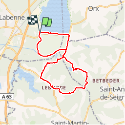
Ruta Senderismo de 15,5 km a descubrir en Nueva Aquitania, Landas, Labenne. Esta ruta ha sido propuesta por tracegps.
Descripción
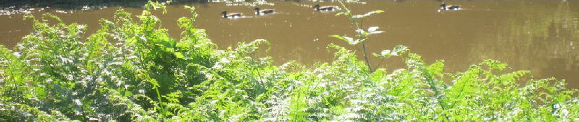
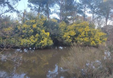
Une randonnée agréable notamment autour du marais (faune principalement). Un détour par les alentours avec un peu de route mais très sympathique. Si vous êtes photos, prenez un petit téléobjectif (70-200).
Localización
País:
France
Región :
Nueva Aquitania
Departamento/provincia :
Landas
Municipio :
Labenne
Localidad:
Unknown
Salida:(Dec)
Salida:(UTM)
628507 ; 4827510 (30T) N.
Comentarios
Excursiones cerca
![Excursión Senderismo Capbreton - Capbreton le boudigaut la chapelle - Photo](https://media.geolcdn.com/t/375/260/0f280e2b-cfd3-47c7-9425-b7e5235e1ad5.jpg&format=jpg&maxdim=2)
![Senderismo Senderismo](https://static1.geolcdn.com/sitytour/trail-icons/101.png)
Capbreton le boudigaut la chapelle
Senderismo
Medio
Capbreton,
Nueva Aquitania,
Landas,
France
![](/images/other/stat-length.png)
9,8 km | 10,6 km-effort
2h 24min
![](https://static1.geolcdn.com/siteimages/upload/files/16400158638029165_repeat_loop_refresh_sync_direction_icon.png)
Sí
![Excursión Senderismo Ondres - Pinède ondres - Photo](https://media.geolcdn.com/t/375/260/ext.jpg?maxdim=2&url=https%3A%2F%2Fstatic1.geolcdn.com%2Fsiteimages%2Fupload%2Ffiles%2F1553511878bg_sport_marche.png)
![Senderismo Senderismo](https://static1.geolcdn.com/sitytour/trail-icons/101.png)
Pinède ondres
Senderismo
Fácil
(2)
Ondres,
Nueva Aquitania,
Landas,
France
![](/images/other/stat-length.png)
9,1 km | 10,1 km-effort
2h 14min
![](https://static1.geolcdn.com/siteimages/upload/files/16400158638029165_repeat_loop_refresh_sync_direction_icon.png)
Sí
![Excursión A pie Labenne - Pinède Ondres Jaune - Photo](https://media.geolcdn.com/t/375/260/b4b1e7a3-b617-4f71-bdd9-7457a045d6c9.jpeg&format=jpg&maxdim=2)
![A pie A pie](https://static1.geolcdn.com/sitytour/trail-icons/100.png)
Pinède Ondres Jaune
A pie
Fácil
Labenne,
Nueva Aquitania,
Landas,
France
![](/images/other/stat-length.png)
5,4 km | 6,1 km-effort
1h 22min
![](https://static1.geolcdn.com/siteimages/upload/files/16400158638029165_repeat_loop_refresh_sync_direction_icon.png)
No
![Excursión Bici de montaña Bénesse-Maremne - Tour benesse - Photo](https://media.geolcdn.com/t/375/260/5c70f6a6-62fc-4eb2-a177-d0b0bc0632ff.jpg&format=jpg&maxdim=2)
![Bici de montaña Bici de montaña](https://static1.geolcdn.com/sitytour/trail-icons/202.png)
Tour benesse
Bici de montaña
Fácil
Bénesse-Maremne,
Nueva Aquitania,
Landas,
France
![](/images/other/stat-length.png)
26 km | 29 km-effort
2h 23min
![](https://static1.geolcdn.com/siteimages/upload/files/16400158638029165_repeat_loop_refresh_sync_direction_icon.png)
Sí
![Excursión Senderismo Ondres - Ondres nord 5.1 - Photo](https://media.geolcdn.com/t/375/260/ext.jpg?maxdim=2&url=https%3A%2F%2Fstatic1.geolcdn.com%2Fsiteimages%2Fupload%2Ffiles%2F1553511878bg_sport_marche.png)
![Senderismo Senderismo](https://static1.geolcdn.com/sitytour/trail-icons/101.png)
Ondres nord 5.1
Senderismo
Muy fácil
Ondres,
Nueva Aquitania,
Landas,
France
![](/images/other/stat-length.png)
9,1 km | 9,8 km-effort
3h 10min
![](https://static1.geolcdn.com/siteimages/upload/files/16400158638029165_repeat_loop_refresh_sync_direction_icon.png)
Sí
![Excursión Bicicleta Ondres - Ondres Hossegor - Photo](https://media.geolcdn.com/t/375/260/ext.jpg?maxdim=2&url=https%3A%2F%2Fstatic1.geolcdn.com%2Fsiteimages%2Fupload%2Ffiles%2F1524743154velo.jpg)
![Bicicleta Bicicleta](https://static1.geolcdn.com/sitytour/trail-icons/200.png)
Ondres Hossegor
Bicicleta
Muy fácil
Ondres,
Nueva Aquitania,
Landas,
France
![](/images/other/stat-length.png)
38 km | 42 km-effort
3h 21min
![](https://static1.geolcdn.com/siteimages/upload/files/16400158638029165_repeat_loop_refresh_sync_direction_icon.png)
Sí
![Excursión Senderismo Ondres - Ondres 1.2 - Photo](https://media.geolcdn.com/t/375/260/ext.jpg?maxdim=2&url=https%3A%2F%2Fstatic1.geolcdn.com%2Fsiteimages%2Fupload%2Ffiles%2F1553511878bg_sport_marche.png)
![Senderismo Senderismo](https://static1.geolcdn.com/sitytour/trail-icons/101.png)
Ondres 1.2
Senderismo
Muy fácil
Ondres,
Nueva Aquitania,
Landas,
France
![](/images/other/stat-length.png)
8,8 km | 9,7 km-effort
2h 30min
![](https://static1.geolcdn.com/siteimages/upload/files/16400158638029165_repeat_loop_refresh_sync_direction_icon.png)
Sí
![Excursión Senderismo Ondres - Ondres Mardi 1 - Photo](https://media.geolcdn.com/t/375/260/ext.jpg?maxdim=2&url=https%3A%2F%2Fstatic1.geolcdn.com%2Fsiteimages%2Fupload%2Ffiles%2F1553511878bg_sport_marche.png)
![Senderismo Senderismo](https://static1.geolcdn.com/sitytour/trail-icons/101.png)
Ondres Mardi 1
Senderismo
Muy fácil
Ondres,
Nueva Aquitania,
Landas,
France
![](/images/other/stat-length.png)
7,9 km | 8,7 km-effort
2h 27min
![](https://static1.geolcdn.com/siteimages/upload/files/16400158638029165_repeat_loop_refresh_sync_direction_icon.png)
Sí
![Excursión Senderismo Ondres - Ondres nord 5.1 - Photo](https://media.geolcdn.com/t/375/260/ext.jpg?maxdim=2&url=https%3A%2F%2Fstatic1.geolcdn.com%2Fsiteimages%2Fupload%2Ffiles%2F1553511878bg_sport_marche.png)
![Senderismo Senderismo](https://static1.geolcdn.com/sitytour/trail-icons/101.png)
Ondres nord 5.1
Senderismo
Muy fácil
Ondres,
Nueva Aquitania,
Landas,
France
![](/images/other/stat-length.png)
9,1 km | 9,8 km-effort
3h 10min
![](https://static1.geolcdn.com/siteimages/upload/files/16400158638029165_repeat_loop_refresh_sync_direction_icon.png)
Sí