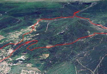
![](/images/other/stat-length.png)
![Excursión Bici de montaña Rougiers - Gorges du Caramy - Rougiers - Photo](https://media.geolcdn.com/t/1900/400/ext.pjpeg?maxdim=2&url=https%3A%2F%2Fservices.sitytrail.com%2FGeolivesWS%2FDownloadMedia.ashx%3FTrailID%3D172387%26Media%3D13735_1.jpg)
Gorges du Caramy - Rougiers
tracegps
Usuario
![Longitud](/images/other/stat-length.png)
![Altitud máxima](https://static1.geolcdn.com/siteimages/upload/files/1508320355ic_sort_altitude_max_24dp.png)
![Desnivel positivo](https://static1.geolcdn.com/siteimages/upload/files/1508320355ic_sort_den_pos_24dp.png)
![Km-Effort](/images/other/stat-length.png)
![Altitud mínima](https://static1.geolcdn.com/siteimages/upload/files/1508320355ic_sort_altitude_min_24dp.png)
![Desnivel negativo](https://static1.geolcdn.com/siteimages/upload/files/1508320355ic_sort_den_neg_24dp.png)
![Boucle](https://static1.geolcdn.com/siteimages/upload/files/16400158638029165_repeat_loop_refresh_sync_direction_icon.png)
![Bici de montaña](https://static1.geolcdn.com/sitytour/trail-icons/202.png)
4h00
Dificultad : Medio
![Escanee este código QR para abrir la excursión en la aplicación SityTrail](https://capi.geolives.com/qq0zvz2zws4bq2lad0pu/sitytour/trails/172387/qr.png?size=200)
Aplicación GPS de excursión GRATIS
A propósito
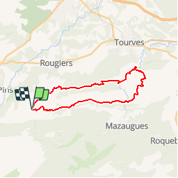
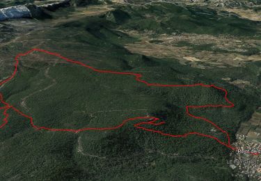
Ruta Bici de montaña de 25 km a descubrir en Provenza-Alpes-Costa Azul, Var, Rougiers. Esta ruta ha sido propuesta por tracegps.
Descripción
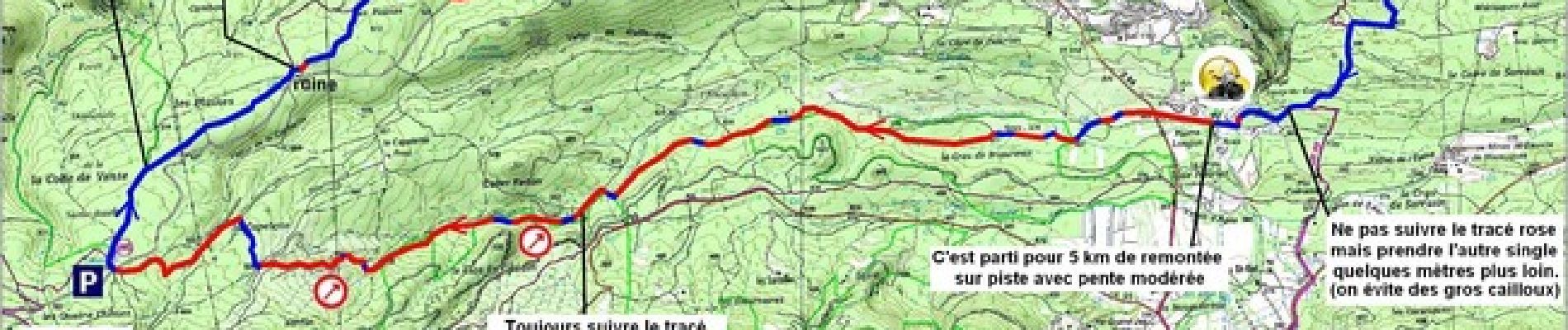
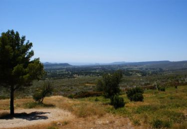
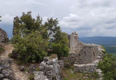
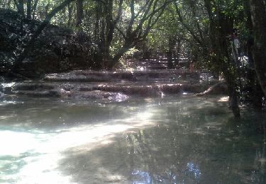
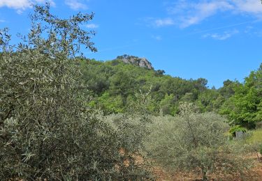
Encore un très joli endroit pour une virée VTT. Notez que le parcours suit pratiquement tout le long un tracé de points roses. Je pense qu'il doit s'agir d'un balisage d'une rando organisée par le club de Rougiers ou de Mazaugues, mais ce n'est qu'une supposition. En tous cas c'est bien pratique et ça facilite grandement la navigation. Dans le Caramy je conseille de poser les vélos quelques minutes et d'aller faire un saut jusqu'à la source La Figuière. En fin de printemps, début d'été, c'est le royaume de libellules bleu acier. Il y en a vraiment beaucoup et c'est un ravissant spectacle. Toute la partie qui mène au pont romain de Cassède laisse entrevoir le cours d'eau entre les arbres et c'est très bucolique. On peut faire la pause ici et en profiter pour se baigner. Surtout que dès le pont franchi on est dans l'ambiance du retour : ça monte raide ! Le départ se fait de l'aire de pique nique des 4 chênes : Après l'Hôtellerie de la Sainte Baume continuer la route. Au premier embranchement rester à droite (direction Mazaugues). A la prochaine bifurcation tourner à gauche (il n'y a aucun panneau mais ça va vers Rougiers). Rouler 1,7 km et se garer au niveau de l'aire de pique-nique avec la grande mare (qui en été est à sec). Attention, du 21 juin au 30 septembre 2012 l'accès aux massifs forestiers du Var est réglementé. Le niveau de danger du jour est défini la veille pour le lendemain à partir de 19h00 et consultable ICI. Bonne randonnée. Vos commentaires et remarques diverses sont les bienvenus. Pour zoomer sur l'image, cliquer sur ce LIEN. (Puis vous activerez le zoom en cliquant sur la loupe avec le signe plus.)
Localización
Comentarios
Excursiones cerca
![Excursión Senderismo Nans-les-Pins - Le baou des glacières - Photo](https://media.geolcdn.com/t/375/260/ext.jpg?maxdim=2&url=https%3A%2F%2Fservices.sitytrail.com%2FGeolivesWS%2FDownloadMedia.ashx%3FTrailID%3D356935%26Media%3Dfix__20141025130409.jpg)
![Senderismo Senderismo](https://static1.geolcdn.com/sitytour/trail-icons/101.png)
Senderismo
![](/images/other/stat-length.png)
![](https://static1.geolcdn.com/siteimages/upload/files/16400158638029165_repeat_loop_refresh_sync_direction_icon.png)
![Excursión Senderismo Rougiers - SityTrail - Rougiers, Piégu, la fontaine de la Guillandière, le Castrum - Photo](https://media.geolcdn.com/t/375/260/81ba1a87-303b-4205-b673-8a1be5b2eb7f.jpg&format=jpg&maxdim=2)
![Senderismo Senderismo](https://static1.geolcdn.com/sitytour/trail-icons/101.png)
Senderismo
![](/images/other/stat-length.png)
![](https://static1.geolcdn.com/siteimages/upload/files/16400158638029165_repeat_loop_refresh_sync_direction_icon.png)
![Excursión Bici de montaña Rougiers - Crêtes de la Sainte Baume et d'Agnis, l'intégrale à VTT - Photo](https://media.geolcdn.com/t/375/260/ext.jpg?maxdim=2&url=https%3A%2F%2Fservices.sitytrail.com%2FGeolivesWS%2FDownloadMedia.ashx%3FTrailID%3D105166%26Media%3D8794_3.jpg)
![Bici de montaña Bici de montaña](https://static1.geolcdn.com/sitytour/trail-icons/202.png)
Bici de montaña
![](/images/other/stat-length.png)
![](https://static1.geolcdn.com/siteimages/upload/files/16400158638029165_repeat_loop_refresh_sync_direction_icon.png)
![Excursión Senderismo Nans-les-Pins - La Croix des Glacières, Sainte-Baume - Photo](https://media.geolcdn.com/t/375/260/ext.jpg?maxdim=2&url=https%3A%2F%2Fservices.sitytrail.com%2FGeolivesWS%2FDownloadMedia.ashx%3FTrailID%3D107654%26Media%3D12647_1.jpg)
![Senderismo Senderismo](https://static1.geolcdn.com/sitytour/trail-icons/101.png)
Senderismo
![](/images/other/stat-length.png)
![](https://static1.geolcdn.com/siteimages/upload/files/16400158638029165_repeat_loop_refresh_sync_direction_icon.png)
![Excursión Senderismo Plan-d'Aups-Sainte-Baume - Sainte Baume par le sentier Marcel d'Estruch - Photo](https://media.geolcdn.com/t/375/260/39d64878-6331-46dd-a0a2-1e73bc67147d.jpg&format=jpg&maxdim=2)
![Senderismo Senderismo](https://static1.geolcdn.com/sitytour/trail-icons/101.png)
Senderismo
![](/images/other/stat-length.png)
![](https://static1.geolcdn.com/siteimages/upload/files/16400158638029165_repeat_loop_refresh_sync_direction_icon.png)
![Excursión Senderismo Rougiers - chapelle et ancien castrum de Saint-Jean - Photo](https://media.geolcdn.com/t/375/260/ext.jpg?maxdim=2&url=https%3A%2F%2Fservices.sitytrail.com%2FGeolivesWS%2FDownloadMedia.ashx%3FTrailID%3D979441%26Media%3Dfix__20180603133323.jpg)
![Senderismo Senderismo](https://static1.geolcdn.com/sitytour/trail-icons/101.png)
Senderismo
![](/images/other/stat-length.png)
![](https://static1.geolcdn.com/siteimages/upload/files/16400158638029165_repeat_loop_refresh_sync_direction_icon.png)
![Excursión Senderismo Nans-les-Pins - les sources de l'huveaune - Photo](https://media.geolcdn.com/t/375/260/ext.jpg?maxdim=2&url=https%3A%2F%2Fservices.sitytrail.com%2FGeolivesWS%2FDownloadMedia.ashx%3FTrailID%3D422210%26Media%3Dfix__20150517145253.jpg)
![Senderismo Senderismo](https://static1.geolcdn.com/sitytour/trail-icons/101.png)
Senderismo
![](/images/other/stat-length.png)
![](https://static1.geolcdn.com/siteimages/upload/files/16400158638029165_repeat_loop_refresh_sync_direction_icon.png)
![Excursión Senderismo Nans-les-Pins - SityTrail - La source de L' huveaune - Vieux nans - grottes - Photo](https://media.geolcdn.com/t/375/260/3fd1d961-d5dd-4429-8f4c-6edd67157481.jpg&format=jpg&maxdim=2)
![Senderismo Senderismo](https://static1.geolcdn.com/sitytour/trail-icons/101.png)
Senderismo
![](/images/other/stat-length.png)
![](https://static1.geolcdn.com/siteimages/upload/files/16400158638029165_repeat_loop_refresh_sync_direction_icon.png)
![Excursión Senderismo Nans-les-Pins - De Nans les pins vers les sources de l'Huveaune - Photo](https://media.geolcdn.com/t/375/260/76803597-2545-40c2-adab-0fe4b317a116.jpg&format=jpg&maxdim=2)
![Senderismo Senderismo](https://static1.geolcdn.com/sitytour/trail-icons/101.png)
Senderismo
![](/images/other/stat-length.png)
![](https://static1.geolcdn.com/siteimages/upload/files/16400158638029165_repeat_loop_refresh_sync_direction_icon.png)