![](/images/other/stat-length.png)
![Excursión Senderismo Bâgé-Dommartin - DOMMARTIN: Circuit Épaisse - Photo](https://media.geolcdn.com/t/1900/400/ext.pjpeg?maxdim=2&url=https%3A%2F%2Fstatic1.geolcdn.com%2Fsiteimages%2Fupload%2Ffiles%2F1553511878bg_sport_marche.png)
DOMMARTIN: Circuit Épaisse
robertdurand
Usuario
![Longitud](/images/other/stat-length.png)
Longitud
16,1 km
![Altitud máxima](https://static1.geolcdn.com/siteimages/upload/files/1508320355ic_sort_altitude_max_24dp.png)
Altitud máxima
219 m
![Desnivel positivo](https://static1.geolcdn.com/siteimages/upload/files/1508320355ic_sort_den_pos_24dp.png)
Desnivel positivo
142 m
![Km-Effort](/images/other/stat-length.png)
Km-Effort
18 km
![Altitud mínima](https://static1.geolcdn.com/siteimages/upload/files/1508320355ic_sort_altitude_min_24dp.png)
Altitud mínima
187 m
![Desnivel negativo](https://static1.geolcdn.com/siteimages/upload/files/1508320355ic_sort_den_neg_24dp.png)
Desnivel negativo
142 m
![Boucle](https://static1.geolcdn.com/siteimages/upload/files/16400158638029165_repeat_loop_refresh_sync_direction_icon.png)
Boucle
Sí
Fecha de creación :
2014-12-10 00:00:00.0
Última modificación :
2014-12-10 00:00:00.0
![Senderismo](https://static1.geolcdn.com/sitytour/trail-icons/101.png)
4h08
Dificultad : Medio
![Escanee este código QR para abrir la excursión en la aplicación SityTrail](https://capi.geolives.com/qq0zvz2zws4bq2lad0pu/sitytour/trails/165561/qr.png?size=200)
Aplicación GPS de excursión GRATIS
A propósito
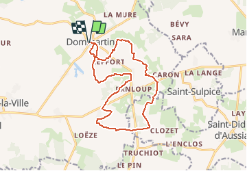
Ruta Senderismo de 16,1 km a descubrir en Auvergne-Rhône-Alpes, Ain, Bâgé-Dommartin. Esta ruta ha sido propuesta por robertdurand.
Descripción
Randonnées au Pays de Bâgé: le Circuit Épaisse vous pemettra de cheminer au cœur du bocage bressan et de ses fermes à pans de bois, puis de longer le domaine de la commanderie des Hospitaliers d'ÉPAISSE.
Localización
País:
France
Región :
Auvergne-Rhône-Alpes
Departamento/provincia :
Ain
Municipio :
Bâgé-Dommartin
Localidad:
Unknown
Salida:(Dec)
Salida:(UTM)
653061 ; 5133425 (31T) N.
Comentarios
Excursiones cerca
![Excursión Senderismo Chevroux - Chevroux - Photo](https://media.geolcdn.com/t/375/260/ext.jpg?maxdim=2&url=https%3A%2F%2Fstatic1.geolcdn.com%2Fsiteimages%2Fupload%2Ffiles%2F1553511878bg_sport_marche.png)
![Senderismo Senderismo](https://static1.geolcdn.com/sitytour/trail-icons/101.png)
Chevroux
Senderismo
Medio
Chevroux,
Auvergne-Rhône-Alpes,
Ain,
France
![](/images/other/stat-length.png)
6,7 km | 7,4 km-effort
1h 36min
![](https://static1.geolcdn.com/siteimages/upload/files/16400158638029165_repeat_loop_refresh_sync_direction_icon.png)
Sí
![Excursión Senderismo Saint-Sulpice - Ballades des Papilles 2013à St Didier D'Aussiat - Photo](https://media.geolcdn.com/t/375/260/ext.jpg?maxdim=2&url=https%3A%2F%2Fstatic1.geolcdn.com%2Fsiteimages%2Fupload%2Ffiles%2F1553511878bg_sport_marche.png)
![Senderismo Senderismo](https://static1.geolcdn.com/sitytour/trail-icons/101.png)
Ballades des Papilles 2013à St Didier D'Aussiat
Senderismo
Medio
Saint-Sulpice,
Auvergne-Rhône-Alpes,
Ain,
France
![](/images/other/stat-length.png)
15,7 km | 17,9 km-effort
3h 55min
![](https://static1.geolcdn.com/siteimages/upload/files/16400158638029165_repeat_loop_refresh_sync_direction_icon.png)
Sí
![Excursión Senderismo Bâgé-Dommartin - DOMMARTIN: Circuit Épaisse - Photo](https://media.geolcdn.com/t/375/260/ext.jpg?maxdim=2&url=https%3A%2F%2Fstatic1.geolcdn.com%2Fsiteimages%2Fupload%2Ffiles%2F1553511878bg_sport_marche.png)
![Senderismo Senderismo](https://static1.geolcdn.com/sitytour/trail-icons/101.png)
DOMMARTIN: Circuit Épaisse
Senderismo
Medio
Bâgé-Dommartin,
Auvergne-Rhône-Alpes,
Ain,
France
![](/images/other/stat-length.png)
16,1 km | 18 km-effort
4h 8min
![](https://static1.geolcdn.com/siteimages/upload/files/16400158638029165_repeat_loop_refresh_sync_direction_icon.png)
Sí
![Excursión Senderismo Bâgé-Dommartin - Dommartin: le Circuit des Nénuphars - Photo](https://media.geolcdn.com/t/375/260/ext.jpg?maxdim=2&url=https%3A%2F%2Fstatic1.geolcdn.com%2Fsiteimages%2Fupload%2Ffiles%2F1553511878bg_sport_marche.png)
![Senderismo Senderismo](https://static1.geolcdn.com/sitytour/trail-icons/101.png)
Dommartin: le Circuit des Nénuphars
Senderismo
Muy fácil
Bâgé-Dommartin,
Auvergne-Rhône-Alpes,
Ain,
France
![](/images/other/stat-length.png)
6,5 km | 7,2 km-effort
1h 36min
![](https://static1.geolcdn.com/siteimages/upload/files/16400158638029165_repeat_loop_refresh_sync_direction_icon.png)
Sí
![Excursión Senderismo Bâgé-Dommartin - DOMMARTIN: Circuit de la Pérouse - Photo](https://media.geolcdn.com/t/375/260/ext.jpg?maxdim=2&url=https%3A%2F%2Fstatic1.geolcdn.com%2Fsiteimages%2Fupload%2Ffiles%2F1553511878bg_sport_marche.png)
![Senderismo Senderismo](https://static1.geolcdn.com/sitytour/trail-icons/101.png)
DOMMARTIN: Circuit de la Pérouse
Senderismo
Fácil
Bâgé-Dommartin,
Auvergne-Rhône-Alpes,
Ain,
France
![](/images/other/stat-length.png)
7,7 km | 8,7 km-effort
1h 55min
![](https://static1.geolcdn.com/siteimages/upload/files/16400158638029165_repeat_loop_refresh_sync_direction_icon.png)
Sí
![Excursión Senderismo Bâgé-le-Châtel - Bâgé-la Ville: Pailladières - Photo](https://media.geolcdn.com/t/375/260/ext.jpg?maxdim=2&url=https%3A%2F%2Fstatic1.geolcdn.com%2Fsiteimages%2Fupload%2Ffiles%2F1553511878bg_sport_marche.png)
![Senderismo Senderismo](https://static1.geolcdn.com/sitytour/trail-icons/101.png)
Bâgé-la Ville: Pailladières
Senderismo
Difícil
Bâgé-le-Châtel,
Auvergne-Rhône-Alpes,
Ain,
France
![](/images/other/stat-length.png)
27 km | 30 km-effort
7h 2min
![](https://static1.geolcdn.com/siteimages/upload/files/16400158638029165_repeat_loop_refresh_sync_direction_icon.png)
Sí
![Excursión Senderismo Bâgé-le-Châtel - Bâgé-le Chatel: les 3 Châteaux - Photo](https://media.geolcdn.com/t/375/260/ext.jpg?maxdim=2&url=https%3A%2F%2Fstatic1.geolcdn.com%2Fsiteimages%2Fupload%2Ffiles%2F1553511878bg_sport_marche.png)
![Senderismo Senderismo](https://static1.geolcdn.com/sitytour/trail-icons/101.png)
Bâgé-le Chatel: les 3 Châteaux
Senderismo
Fácil
Bâgé-le-Châtel,
Auvergne-Rhône-Alpes,
Ain,
France
![](/images/other/stat-length.png)
11,1 km | 12,9 km-effort
2h 30min
![](https://static1.geolcdn.com/siteimages/upload/files/16400158638029165_repeat_loop_refresh_sync_direction_icon.png)
Sí
![Excursión A pie Chevroux - CHEVROUX - Photo](https://media.geolcdn.com/t/375/260/ext.jpg?maxdim=2&url=https%3A%2F%2Fstatic1.geolcdn.com%2Fsiteimages%2Fupload%2Ffiles%2F1545311037marcheuse_200dpi.jpg)
![A pie A pie](https://static1.geolcdn.com/sitytour/trail-icons/100.png)
CHEVROUX
A pie
Fácil
Chevroux,
Auvergne-Rhône-Alpes,
Ain,
France
![](/images/other/stat-length.png)
12,5 km | 13,9 km-effort
3h 9min
![](https://static1.geolcdn.com/siteimages/upload/files/16400158638029165_repeat_loop_refresh_sync_direction_icon.png)
Sí