![](/images/other/stat-length.png)
![Excursión Senderismo Servance-Miellin - Servance - Les noirs étangs - Photo](https://media.geolcdn.com/t/1900/400/ext.pjpeg?maxdim=2&url=https%3A%2F%2Fstatic1.geolcdn.com%2Fsiteimages%2Fupload%2Ffiles%2F1553511878bg_sport_marche.png)
Servance - Les noirs étangs
ballet
Usuario
![Longitud](/images/other/stat-length.png)
Longitud
17,2 km
![Altitud máxima](https://static1.geolcdn.com/siteimages/upload/files/1508320355ic_sort_altitude_max_24dp.png)
Altitud máxima
784 m
![Desnivel positivo](https://static1.geolcdn.com/siteimages/upload/files/1508320355ic_sort_den_pos_24dp.png)
Desnivel positivo
497 m
![Km-Effort](/images/other/stat-length.png)
Km-Effort
24 km
![Altitud mínima](https://static1.geolcdn.com/siteimages/upload/files/1508320355ic_sort_altitude_min_24dp.png)
Altitud mínima
408 m
![Desnivel negativo](https://static1.geolcdn.com/siteimages/upload/files/1508320355ic_sort_den_neg_24dp.png)
Desnivel negativo
497 m
![Boucle](https://static1.geolcdn.com/siteimages/upload/files/16400158638029165_repeat_loop_refresh_sync_direction_icon.png)
Boucle
Sí
Fecha de creación :
2014-12-10 00:00:00.0
Última modificación :
2014-12-10 00:00:00.0
![Senderismo](https://static1.geolcdn.com/sitytour/trail-icons/101.png)
4h10
Dificultad : Medio
![Escanee este código QR para abrir la excursión en la aplicación SityTrail](https://capi.geolives.com/qq0zvz2zws4bq2lad0pu/sitytour/trails/161953/qr.png?size=200)
Aplicación GPS de excursión GRATIS
A propósito
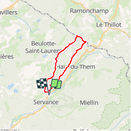
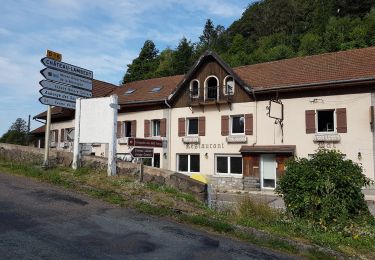
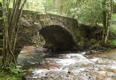
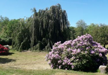
Ruta Senderismo de 17,2 km a descubrir en Borgoña-Franco Condado, Alto Saona, Servance-Miellin. Esta ruta ha sido propuesta por ballet.
Descripción
Montée en suivant un ruisseau dans une vallée et descente sur la crête surplombant le Haut du Them
Localización
País:
France
Región :
Borgoña-Franco Condado
Departamento/provincia :
Alto Saona
Municipio :
Servance-Miellin
Localidad:
Unknown
Salida:(Dec)
Salida:(UTM)
326767 ; 5298574 (32T) N.
Comentarios
Excursiones cerca
![Excursión Senderismo Beulotte-Saint-Laurent - Randonnée des étangs - Beulotte Saint Laurent - Photo](https://media.geolcdn.com/t/375/260/ext.jpg?maxdim=2&url=https%3A%2F%2Fservices.sitytrail.com%2FGeolivesWS%2FDownloadMedia.ashx%3FTrailID%3D107231%26Media%3D12098_5.jpg)
![Senderismo Senderismo](https://static1.geolcdn.com/sitytour/trail-icons/101.png)
Randonnée des étangs - Beulotte Saint Laurent
Senderismo
Medio
(4)
Beulotte-Saint-Laurent,
Borgoña-Franco Condado,
Alto Saona,
France
![](/images/other/stat-length.png)
10,7 km | 13,9 km-effort
2h 30min
![](https://static1.geolcdn.com/siteimages/upload/files/16400158638029165_repeat_loop_refresh_sync_direction_icon.png)
Sí
![Excursión Senderismo Beulotte-Saint-Laurent - Beulotte-Saint-Laurent 13 700m + 317m - Photo](https://media.geolcdn.com/t/375/260/ext.jpg?maxdim=2&url=https%3A%2F%2Fstatic1.geolcdn.com%2Fsiteimages%2Fupload%2Ffiles%2F1553511878bg_sport_marche.png)
![Senderismo Senderismo](https://static1.geolcdn.com/sitytour/trail-icons/101.png)
Beulotte-Saint-Laurent 13 700m + 317m
Senderismo
Fácil
(1)
Beulotte-Saint-Laurent,
Borgoña-Franco Condado,
Alto Saona,
France
![](/images/other/stat-length.png)
13,7 km | 17,9 km-effort
3h 50min
![](https://static1.geolcdn.com/siteimages/upload/files/16400158638029165_repeat_loop_refresh_sync_direction_icon.png)
Sí
![Excursión Senderismo Haut-du-Them-Château-Lambert - Chateau-Lambert mines de cuivre et source de l'Oignon - Photo](https://media.geolcdn.com/t/375/260/ext.jpg?maxdim=2&url=https%3A%2F%2Fstatic1.geolcdn.com%2Fsiteimages%2Fupload%2Ffiles%2F1553511878bg_sport_marche.png)
![Senderismo Senderismo](https://static1.geolcdn.com/sitytour/trail-icons/101.png)
Chateau-Lambert mines de cuivre et source de l'Oignon
Senderismo
Fácil
(1)
Haut-du-Them-Château-Lambert,
Borgoña-Franco Condado,
Alto Saona,
France
![](/images/other/stat-length.png)
9,6 km | 14,6 km-effort
2h 30min
![](https://static1.geolcdn.com/siteimages/upload/files/16400158638029165_repeat_loop_refresh_sync_direction_icon.png)
Sí
![Excursión Senderismo Servance-Miellin - 20230616 la petite Finlande - Photo](https://media.geolcdn.com/t/375/260/b19527b0-70e6-4e00-b48b-d0fb85eecf23.jpg&format=jpg&maxdim=2)
![Senderismo Senderismo](https://static1.geolcdn.com/sitytour/trail-icons/101.png)
20230616 la petite Finlande
Senderismo
Medio
Servance-Miellin,
Borgoña-Franco Condado,
Alto Saona,
France
![](/images/other/stat-length.png)
8,4 km | 10 km-effort
3h 25min
![](https://static1.geolcdn.com/siteimages/upload/files/16400158638029165_repeat_loop_refresh_sync_direction_icon.png)
Sí
![Excursión Senderismo Beulotte-Saint-Laurent - Beulotte St Laurent - le plateau des Mille Etangs - Photo](https://media.geolcdn.com/t/375/260/e526a3c8-361b-4678-a970-15d98b11e7c3.jpg&format=jpg&maxdim=2)
![Senderismo Senderismo](https://static1.geolcdn.com/sitytour/trail-icons/101.png)
Beulotte St Laurent - le plateau des Mille Etangs
Senderismo
Difícil
Beulotte-Saint-Laurent,
Borgoña-Franco Condado,
Alto Saona,
France
![](/images/other/stat-length.png)
22 km | 28 km-effort
4h 45min
![](https://static1.geolcdn.com/siteimages/upload/files/16400158638029165_repeat_loop_refresh_sync_direction_icon.png)
Sí
![Excursión Senderismo Ternuay-Melay-et-Saint-Hilaire - Ternuay. - Photo](https://media.geolcdn.com/t/375/260/403c1459-cf5b-41ce-b83f-f3eadbfddf30.jpg&format=jpg&maxdim=2)
![Senderismo Senderismo](https://static1.geolcdn.com/sitytour/trail-icons/101.png)
Ternuay.
Senderismo
Fácil
Ternuay-Melay-et-Saint-Hilaire,
Borgoña-Franco Condado,
Alto Saona,
France
![](/images/other/stat-length.png)
12,6 km | 16,2 km-effort
3h 31min
![](https://static1.geolcdn.com/siteimages/upload/files/16400158638029165_repeat_loop_refresh_sync_direction_icon.png)
Sí
![Excursión Senderismo Le Thillot - Col des Croix - Vierge des Neiges - Hautes Mines - Tête des Noirs Étangs - Château Lambert - Photo](https://media.geolcdn.com/t/375/260/dd7bdea5-b733-4b98-94f9-1f87ee811abf.jpg&format=jpg&maxdim=2)
![Senderismo Senderismo](https://static1.geolcdn.com/sitytour/trail-icons/101.png)
Col des Croix - Vierge des Neiges - Hautes Mines - Tête des Noirs Étangs - Ch...
Senderismo
Fácil
Le Thillot,
Gran Este,
Vosgos,
France
![](/images/other/stat-length.png)
10,5 km | 16 km-effort
2h 23min
![](https://static1.geolcdn.com/siteimages/upload/files/16400158638029165_repeat_loop_refresh_sync_direction_icon.png)
Sí
![Excursión Senderismo Servance-Miellin - Belfahy depuis Miellin - Photo](https://media.geolcdn.com/t/375/260/affc61f4-0ec2-4c6a-a8b6-ea7a60025d69.jpg&format=jpg&maxdim=2)
![Senderismo Senderismo](https://static1.geolcdn.com/sitytour/trail-icons/101.png)
Belfahy depuis Miellin
Senderismo
Medio
Servance-Miellin,
Borgoña-Franco Condado,
Alto Saona,
France
![](/images/other/stat-length.png)
13,5 km | 21 km-effort
3h 4min
![](https://static1.geolcdn.com/siteimages/upload/files/16400158638029165_repeat_loop_refresh_sync_direction_icon.png)
Sí
![Excursión Bicicleta híbrida Servance-Miellin - sur le plateaux des 1000 etangs en vtc - Photo](https://media.geolcdn.com/t/375/260/c0b0996d-7e85-47c6-beca-4638bc3582d4.jpg&format=jpg&maxdim=2)
![Bicicleta híbrida Bicicleta híbrida](https://static1.geolcdn.com/sitytour/trail-icons/203.png)
sur le plateaux des 1000 etangs en vtc
Bicicleta híbrida
Medio
Servance-Miellin,
Borgoña-Franco Condado,
Alto Saona,
France
![](/images/other/stat-length.png)
33 km | 42 km-effort
2h 12min
![](https://static1.geolcdn.com/siteimages/upload/files/16400158638029165_repeat_loop_refresh_sync_direction_icon.png)
No