![](/images/other/stat-length.png)
![Excursión Senderismo Esmoulières - Saphoz - Beulotte-St-Laurent - Photo](https://media.geolcdn.com/t/1900/400/ext.pjpeg?maxdim=2&url=https%3A%2F%2Fstatic1.geolcdn.com%2Fsiteimages%2Fupload%2Ffiles%2F1553511878bg_sport_marche.png)
Saphoz - Beulotte-St-Laurent
ballet
Usuario
![Longitud](/images/other/stat-length.png)
Longitud
30 km
![Altitud máxima](https://static1.geolcdn.com/siteimages/upload/files/1508320355ic_sort_altitude_max_24dp.png)
Altitud máxima
708 m
![Desnivel positivo](https://static1.geolcdn.com/siteimages/upload/files/1508320355ic_sort_den_pos_24dp.png)
Desnivel positivo
715 m
![Km-Effort](/images/other/stat-length.png)
Km-Effort
40 km
![Altitud mínima](https://static1.geolcdn.com/siteimages/upload/files/1508320355ic_sort_altitude_min_24dp.png)
Altitud mínima
365 m
![Desnivel negativo](https://static1.geolcdn.com/siteimages/upload/files/1508320355ic_sort_den_neg_24dp.png)
Desnivel negativo
715 m
![Boucle](https://static1.geolcdn.com/siteimages/upload/files/16400158638029165_repeat_loop_refresh_sync_direction_icon.png)
Boucle
Sí
Fecha de creación :
2014-12-10 00:00:00.0
Última modificación :
2014-12-10 00:00:00.0
![Senderismo](https://static1.geolcdn.com/sitytour/trail-icons/101.png)
7h00
Dificultad : Difícil
![Escanee este código QR para abrir la excursión en la aplicación SityTrail](https://capi.geolives.com/qq0zvz2zws4bq2lad0pu/sitytour/trails/161153/qr.png?size=200)
Aplicación GPS de excursión GRATIS
A propósito
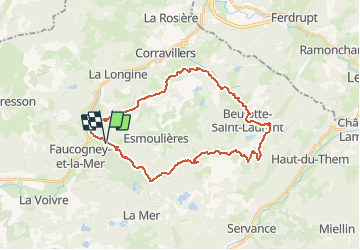
Ruta Senderismo de 30 km a descubrir en Borgoña-Franco Condado, Alto Saona, Esmoulières. Esta ruta ha sido propuesta por ballet.
Descripción
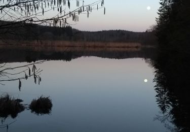
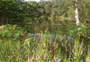
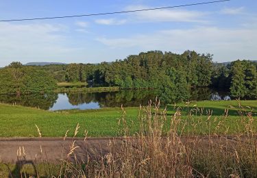
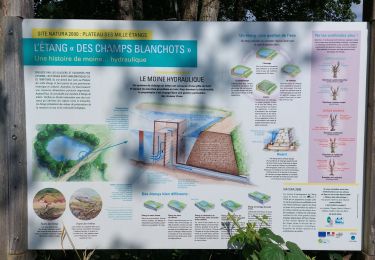
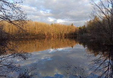
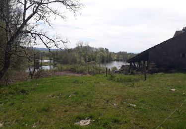
Les milles étangs ou la petite finlande.
Marche difficile par sa longueur mais pas par le dénivelé.
Localización
País:
France
Región :
Borgoña-Franco Condado
Departamento/provincia :
Alto Saona
Municipio :
Esmoulières
Localidad:
Unknown
Salida:(Dec)
Salida:(UTM)
319029 ; 5302457 (32T) N.
Comentarios
Excursiones cerca
![Excursión Senderismo Faucogney-et-la-Mer - 08-02-20 La mer, étang de Pierre Plate et retour. - Photo](https://media.geolcdn.com/t/375/260/1db8c6b9-2ea1-4f8e-aef5-d4d9373f14e8.jpg&format=jpg&maxdim=2)
![Senderismo Senderismo](https://static1.geolcdn.com/sitytour/trail-icons/101.png)
08-02-20 La mer, étang de Pierre Plate et retour.
Senderismo
Muy fácil
(1)
Faucogney-et-la-Mer,
Borgoña-Franco Condado,
Alto Saona,
France
![](/images/other/stat-length.png)
9,9 km | 12,3 km-effort
2h 4min
![](https://static1.geolcdn.com/siteimages/upload/files/16400158638029165_repeat_loop_refresh_sync_direction_icon.png)
Sí
![Excursión Senderismo Faucogney-et-la-Mer - 07-09-24 Faucogney et étangs - Photo](https://media.geolcdn.com/t/375/260/b632af35-b5e7-4ee3-bdb7-f343582d930c.jpg&format=jpg&maxdim=2)
![Senderismo Senderismo](https://static1.geolcdn.com/sitytour/trail-icons/101.png)
07-09-24 Faucogney et étangs
Senderismo
Medio
Faucogney-et-la-Mer,
Borgoña-Franco Condado,
Alto Saona,
France
![](/images/other/stat-length.png)
9,1 km | 13,4 km-effort
2h 41min
![](https://static1.geolcdn.com/siteimages/upload/files/16400158638029165_repeat_loop_refresh_sync_direction_icon.png)
Sí
![Excursión Senderismo Esmoulières - 08-07-23 circuit du plateau d'Esmoulieres - Photo](https://media.geolcdn.com/t/375/260/21f889c5-6bb0-42f1-a5cd-25c10161a5bd.jpg&format=jpg&maxdim=2)
![Senderismo Senderismo](https://static1.geolcdn.com/sitytour/trail-icons/101.png)
08-07-23 circuit du plateau d'Esmoulieres
Senderismo
Medio
Esmoulières,
Borgoña-Franco Condado,
Alto Saona,
France
![](/images/other/stat-length.png)
8,7 km | 11 km-effort
2h 2min
![](https://static1.geolcdn.com/siteimages/upload/files/16400158638029165_repeat_loop_refresh_sync_direction_icon.png)
Sí
![Excursión Senderismo Esmoulières - Esmoulières rando réelle - Photo](https://media.geolcdn.com/t/375/260/2ad0b972-a66a-4cdb-926e-a4b4f6e7eb9d.jpg&format=jpg&maxdim=2)
![Senderismo Senderismo](https://static1.geolcdn.com/sitytour/trail-icons/101.png)
Esmoulières rando réelle
Senderismo
Medio
Esmoulières,
Borgoña-Franco Condado,
Alto Saona,
France
![](/images/other/stat-length.png)
9,2 km | 11,5 km-effort
3h 11min
![](https://static1.geolcdn.com/siteimages/upload/files/16400158638029165_repeat_loop_refresh_sync_direction_icon.png)
Sí
![Excursión sport Amont-et-Effreney - 2023-05-27_12h07m26_randonnee-33932321-effreney-la-noz-du-pin-effreney (3) - Photo](https://media.geolcdn.com/t/375/260/ext.jpg?maxdim=2&url=https%3A%2F%2Fsecurestorage.geolives.com%2Fsitytour%2Ftrail-bg%2Fdefault.jpg)
2023-05-27_12h07m26_randonnee-33932321-effreney-la-noz-du-pin-effreney (3)
sport
Muy fácil
(1)
Amont-et-Effreney,
Borgoña-Franco Condado,
Alto Saona,
France
![](/images/other/stat-length.png)
18,5 km | 24 km-effort
Desconocido
![](https://static1.geolcdn.com/siteimages/upload/files/16400158638029165_repeat_loop_refresh_sync_direction_icon.png)
Sí
![Excursión Senderismo Faucogney-et-la-Mer - la mzr - Photo](https://media.geolcdn.com/t/375/260/4085d514-fed2-4f1a-a225-1e5c9d3a718a.jpg&format=jpg&maxdim=2)
![Senderismo Senderismo](https://static1.geolcdn.com/sitytour/trail-icons/101.png)
la mzr
Senderismo
Muy difícil
Faucogney-et-la-Mer,
Borgoña-Franco Condado,
Alto Saona,
France
![](/images/other/stat-length.png)
18,7 km | 24 km-effort
6h 17min
![](https://static1.geolcdn.com/siteimages/upload/files/16400158638029165_repeat_loop_refresh_sync_direction_icon.png)
Sí
![Excursión Senderismo Faucogney-et-la-Mer - 23-02-22 marche Oroz, étangs... - Photo](https://media.geolcdn.com/t/375/260/65fda660-2809-43eb-960c-29389fba8610.jpg&format=jpg&maxdim=2)
![Senderismo Senderismo](https://static1.geolcdn.com/sitytour/trail-icons/101.png)
23-02-22 marche Oroz, étangs...
Senderismo
Medio
Faucogney-et-la-Mer,
Borgoña-Franco Condado,
Alto Saona,
France
![](/images/other/stat-length.png)
11,9 km | 15,6 km-effort
2h 49min
![](https://static1.geolcdn.com/siteimages/upload/files/16400158638029165_repeat_loop_refresh_sync_direction_icon.png)
Sí
![Excursión Senderismo Esmoulières - randonnée Esmoulières - Photo](https://media.geolcdn.com/t/375/260/7f47e7bf-f81f-49bc-a1e2-a515b0b4f26a.jpg&format=jpg&maxdim=2)
![Senderismo Senderismo](https://static1.geolcdn.com/sitytour/trail-icons/101.png)
randonnée Esmoulières
Senderismo
Medio
Esmoulières,
Borgoña-Franco Condado,
Alto Saona,
France
![](/images/other/stat-length.png)
8,3 km | 10,5 km-effort
2h 4min
![](https://static1.geolcdn.com/siteimages/upload/files/16400158638029165_repeat_loop_refresh_sync_direction_icon.png)
Sí
![Excursión Senderismo La Voivre - Annegray - Etang de la plate pierre - La Chapelle St-Colomban - Photo](https://media.geolcdn.com/t/375/260/ext.jpg?maxdim=2&url=https%3A%2F%2Fstatic1.geolcdn.com%2Fsiteimages%2Fupload%2Ffiles%2F1553511878bg_sport_marche.png)
![Senderismo Senderismo](https://static1.geolcdn.com/sitytour/trail-icons/101.png)
Annegray - Etang de la plate pierre - La Chapelle St-Colomban
Senderismo
Fácil
(2)
La Voivre,
Borgoña-Franco Condado,
Alto Saona,
France
![](/images/other/stat-length.png)
8 km | 10,2 km-effort
2h 0min
![](https://static1.geolcdn.com/siteimages/upload/files/16400158638029165_repeat_loop_refresh_sync_direction_icon.png)
Sí