![](/images/other/stat-length.png)
![Excursión Senderismo Théminettes - Theminettes dolmen - Photo](https://media.geolcdn.com/t/1900/400/ext.pjpeg?maxdim=2&url=https%3A%2F%2Fservices.sitytrail.com%2FGeolivesWS%2FDownloadMedia.ashx%3FTrailID%3D160446%26Media%3D20121022111128.jpg)
Theminettes dolmen
gannet1
Usuario
![Longitud](/images/other/stat-length.png)
Longitud
9,8 km
![Altitud máxima](https://static1.geolcdn.com/siteimages/upload/files/1508320355ic_sort_altitude_max_24dp.png)
Altitud máxima
360 m
![Desnivel positivo](https://static1.geolcdn.com/siteimages/upload/files/1508320355ic_sort_den_pos_24dp.png)
Desnivel positivo
121 m
![Km-Effort](/images/other/stat-length.png)
Km-Effort
11,4 km
![Altitud mínima](https://static1.geolcdn.com/siteimages/upload/files/1508320355ic_sort_altitude_min_24dp.png)
Altitud mínima
331 m
![Desnivel negativo](https://static1.geolcdn.com/siteimages/upload/files/1508320355ic_sort_den_neg_24dp.png)
Desnivel negativo
121 m
![Boucle](https://static1.geolcdn.com/siteimages/upload/files/16400158638029165_repeat_loop_refresh_sync_direction_icon.png)
Boucle
Sí
Fecha de creación :
2014-12-10 00:00:00.0
Última modificación :
2014-12-10 00:00:00.0
![Senderismo](https://static1.geolcdn.com/sitytour/trail-icons/101.png)
2h29
Dificultad : Muy fácil
![Escanee este código QR para abrir la excursión en la aplicación SityTrail](https://capi.geolives.com/qq0zvz2zws4bq2lad0pu/sitytour/trails/160446/qr.png?size=200)
Aplicación GPS de excursión GRATIS
A propósito
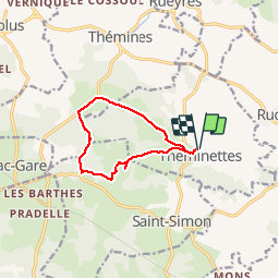
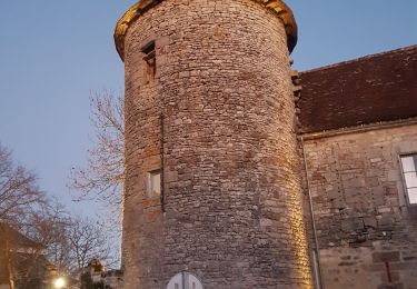
Ruta Senderismo de 9,8 km a descubrir en Occitania, Lot, Théminettes. Esta ruta ha sido propuesta por gannet1.
Descripción
Passage près d''un dolmen un peu hors parcours. Causse et campagne plus verdoyante.
Testé par le groupe de marche SELM
Localización
País:
France
Región :
Occitania
Departamento/provincia :
Lot
Municipio :
Théminettes
Localidad:
Unknown
Salida:(Dec)
Salida:(UTM)
409227 ; 4951909 (31T) N.
Comentarios
Excursiones cerca
![Excursión Senderismo Sonac - Theminettes Les Causses - Photo](https://media.geolcdn.com/t/375/260/ext.jpg?maxdim=2&url=https%3A%2F%2Fservices.sitytrail.com%2FGeolivesWS%2FDownloadMedia.ashx%3FTrailID%3D160443%26Media%3D20121023125402.jpg)
![Senderismo Senderismo](https://static1.geolcdn.com/sitytour/trail-icons/101.png)
Theminettes Les Causses
Senderismo
Fácil
(4)
Sonac,
Occitania,
Lot,
France
![](/images/other/stat-length.png)
14,6 km | 17,3 km-effort
3h 46min
![](https://static1.geolcdn.com/siteimages/upload/files/16400158638029165_repeat_loop_refresh_sync_direction_icon.png)
No
![Excursión Senderismo Théminettes - Theminette - Photo](https://media.geolcdn.com/t/375/260/adeaa135-be59-4b8f-868d-d1ce531ee5e6.jpg&format=jpg&maxdim=2)
![Senderismo Senderismo](https://static1.geolcdn.com/sitytour/trail-icons/101.png)
Theminette
Senderismo
Fácil
Théminettes,
Occitania,
Lot,
France
![](/images/other/stat-length.png)
10,7 km | 12,4 km-effort
2h 36min
![](https://static1.geolcdn.com/siteimages/upload/files/16400158638029165_repeat_loop_refresh_sync_direction_icon.png)
Sí
![Senderismo Senderismo](https://static1.geolcdn.com/sitytour/trail-icons/101.png)
Themines Rueyres 11km5-12030072
Senderismo
Difícil
Thémines,
Occitania,
Lot,
France
![](/images/other/stat-length.png)
10,8 km | 14 km-effort
3h 10min
![](https://static1.geolcdn.com/siteimages/upload/files/16400158638029165_repeat_loop_refresh_sync_direction_icon.png)
Sí
![Excursión Senderismo Thémines - themine - Photo](https://media.geolcdn.com/t/375/260/17357fcb-7da3-4582-87f7-80fe6979ced1.jpg&format=jpg&maxdim=2)
![Senderismo Senderismo](https://static1.geolcdn.com/sitytour/trail-icons/101.png)
![Excursión Senderismo Rudelle - rudelle - Photo](https://media.geolcdn.com/t/375/260/1d696e71-730a-461e-94a2-fdf8cf6f5b2b.jpg&format=jpg&maxdim=2)
![Senderismo Senderismo](https://static1.geolcdn.com/sitytour/trail-icons/101.png)
![Excursión Senderismo Théminettes - theminettes - Photo](https://media.geolcdn.com/t/375/260/194e6fb8-a32f-4dd5-8298-063d56dd7bef.jpg&format=jpg&maxdim=2)
![Senderismo Senderismo](https://static1.geolcdn.com/sitytour/trail-icons/101.png)
theminettes
Senderismo
Fácil
Théminettes,
Occitania,
Lot,
France
![](/images/other/stat-length.png)
11,9 km | 13,9 km-effort
2h 47min
![](https://static1.geolcdn.com/siteimages/upload/files/16400158638029165_repeat_loop_refresh_sync_direction_icon.png)
Sí
![Excursión Senderismo Rueyres - rueyes rudelle - Photo](https://media.geolcdn.com/t/375/260/ext.jpg?maxdim=2&url=https%3A%2F%2Fstatic1.geolcdn.com%2Fsiteimages%2Fupload%2Ffiles%2F1553511878bg_sport_marche.png)
![Senderismo Senderismo](https://static1.geolcdn.com/sitytour/trail-icons/101.png)
rueyes rudelle
Senderismo
Difícil
Rueyres,
Occitania,
Lot,
France
![](/images/other/stat-length.png)
14,4 km | 18,1 km-effort
3h 32min
![](https://static1.geolcdn.com/siteimages/upload/files/16400158638029165_repeat_loop_refresh_sync_direction_icon.png)
No
![Excursión Senderismo Assier - assier rs - Photo](https://media.geolcdn.com/t/375/260/ext.jpg?maxdim=2&url=https%3A%2F%2Fstatic1.geolcdn.com%2Fsiteimages%2Fupload%2Ffiles%2F1553511878bg_sport_marche.png)
![Senderismo Senderismo](https://static1.geolcdn.com/sitytour/trail-icons/101.png)
![Excursión Bici de montaña Saint-Simon - reilhac gramat - Photo](https://media.geolcdn.com/t/375/260/ext.jpg?maxdim=2&url=https%3A%2F%2Fstatic1.geolcdn.com%2Fsiteimages%2Fupload%2Ffiles%2F1524743154velo.jpg)
![Bici de montaña Bici de montaña](https://static1.geolcdn.com/sitytour/trail-icons/202.png)
reilhac gramat
Bici de montaña
Fácil
Saint-Simon,
Occitania,
Lot,
France
![](/images/other/stat-length.png)
51 km | 58 km-effort
3h 53min
![](https://static1.geolcdn.com/siteimages/upload/files/16400158638029165_repeat_loop_refresh_sync_direction_icon.png)
Sí