![](/images/other/stat-length.png)
![Excursión Senderismo Soultzeren - LM - Photo](https://media.geolcdn.com/t/1900/400/ext.pjpeg?maxdim=2&url=https%3A%2F%2Fstatic1.geolcdn.com%2Fsiteimages%2Fupload%2Ffiles%2F1553511878bg_sport_marche.png)
LM
dick68
Usuario
![Longitud](/images/other/stat-length.png)
Longitud
10,5 km
![Altitud máxima](https://static1.geolcdn.com/siteimages/upload/files/1508320355ic_sort_altitude_max_24dp.png)
Altitud máxima
1300 m
![Desnivel positivo](https://static1.geolcdn.com/siteimages/upload/files/1508320355ic_sort_den_pos_24dp.png)
Desnivel positivo
452 m
![Km-Effort](/images/other/stat-length.png)
Km-Effort
16,5 km
![Altitud mínima](https://static1.geolcdn.com/siteimages/upload/files/1508320355ic_sort_altitude_min_24dp.png)
Altitud mínima
1014 m
![Desnivel negativo](https://static1.geolcdn.com/siteimages/upload/files/1508320355ic_sort_den_neg_24dp.png)
Desnivel negativo
453 m
![Boucle](https://static1.geolcdn.com/siteimages/upload/files/16400158638029165_repeat_loop_refresh_sync_direction_icon.png)
Boucle
Sí
Fecha de creación :
2014-12-10 00:00:00.0
Última modificación :
2014-12-10 00:00:00.0
![Senderismo](https://static1.geolcdn.com/sitytour/trail-icons/101.png)
--
Dificultad : Medio
![Escanee este código QR para abrir la excursión en la aplicación SityTrail](https://capi.geolives.com/qq0zvz2zws4bq2lad0pu/sitytour/trails/144450/qr.png?size=200)
Aplicación GPS de excursión GRATIS
A propósito
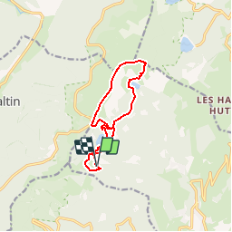
Ruta Senderismo de 10,5 km a descubrir en Gran Este, Alto Rin, Soultzeren. Esta ruta ha sido propuesta por dick68.
Descripción
Parking du Téleski - Lac Vert - Lac des Truites - Gazon du Faing - Dreieck - Refuge CV Ericson - Lac Vert - Saestaetlé - Parking
Localización
País:
France
Región :
Gran Este
Departamento/provincia :
Alto Rin
Municipio :
Soultzeren
Localidad:
Unknown
Salida:(Dec)
Salida:(UTM)
355719 ; 5327259 (32U) N.
Comentarios
Excursiones cerca
![Excursión Paseo ecuestre Orbey - 2020-06-28 WE Orbey Petit Hohnack Glasborn - Photo](https://media.geolcdn.com/t/375/260/ext.jpg?maxdim=2&url=https%3A%2F%2Fmedia.geolcdn.com%2Ff%2Fef012c2d-591e-4a7a-ae45-376661550d14.jpg)
![Paseo ecuestre Paseo ecuestre](https://static1.geolcdn.com/sitytour/trail-icons/301.png)
2020-06-28 WE Orbey Petit Hohnack Glasborn
Paseo ecuestre
Difícil
(1)
Orbey,
Gran Este,
Alto Rin,
France
![](/images/other/stat-length.png)
22 km | 31 km-effort
4h 5min
![](https://static1.geolcdn.com/siteimages/upload/files/16400158638029165_repeat_loop_refresh_sync_direction_icon.png)
Sí
![Excursión Paseo ecuestre Orbey - 2020-06-27 WE Orbey Noir Gazon Vert Forlet - Photo](https://media.geolcdn.com/t/375/260/ext.jpg?maxdim=2&url=https%3A%2F%2Fmedia.geolcdn.com%2Ff%2Ff691f0a3-eb26-4898-acd3-19530bfd0b6d.jpg)
![Paseo ecuestre Paseo ecuestre](https://static1.geolcdn.com/sitytour/trail-icons/301.png)
2020-06-27 WE Orbey Noir Gazon Vert Forlet
Paseo ecuestre
Medio
(1)
Orbey,
Gran Este,
Alto Rin,
France
![](/images/other/stat-length.png)
21 km | 30 km-effort
3h 59min
![](https://static1.geolcdn.com/siteimages/upload/files/16400158638029165_repeat_loop_refresh_sync_direction_icon.png)
Sí
![Excursión Senderismo Stosswihr - Tour du belvedere avec le passage sur les crêtes - Photo](https://media.geolcdn.com/t/375/260/ext.jpg?maxdim=2&url=https%3A%2F%2Fmedia.geolcdn.com%2Ff%2F5b3c85c1-2643-45e9-9769-80e100e05dda.jpg)
![Senderismo Senderismo](https://static1.geolcdn.com/sitytour/trail-icons/101.png)
Tour du belvedere avec le passage sur les crêtes
Senderismo
Muy fácil
(2)
Stosswihr,
Gran Este,
Alto Rin,
France
![](/images/other/stat-length.png)
8,5 km | 0 m-effort
2h 28min
![](https://static1.geolcdn.com/siteimages/upload/files/16400158638029165_repeat_loop_refresh_sync_direction_icon.png)
Sí
![Excursión Otra actividad Soultzeren - Totom 4 lacs - Photo](https://media.geolcdn.com/t/375/260/ext.jpg?maxdim=2&url=https%3A%2F%2Fservices.sitytrail.com%2FGeolivesWS%2FDownloadMedia.ashx%3FTrailID%3D789048%26Media%3D20170713134427.jpg)
![Otra actividad Otra actividad](https://static1.geolcdn.com/sitytour/trail-icons/900.png)
Totom 4 lacs
Otra actividad
Medio
(1)
Soultzeren,
Gran Este,
Alto Rin,
France
![](/images/other/stat-length.png)
15,6 km | 26 km-effort
4h 37min
![](https://static1.geolcdn.com/siteimages/upload/files/16400158638029165_repeat_loop_refresh_sync_direction_icon.png)
Sí
![Excursión Senderismo Hohrod - Circuit historique 1914-18 Hohrodberg - Linge - Photo](https://media.geolcdn.com/t/375/260/ext.jpg?maxdim=2&url=https%3A%2F%2Fservices.sitytrail.com%2FGeolivesWS%2FDownloadMedia.ashx%3FTrailID%3D313116%26Media%3Dfix__20140615152326.jpg)
![Senderismo Senderismo](https://static1.geolcdn.com/sitytour/trail-icons/101.png)
Circuit historique 1914-18 Hohrodberg - Linge
Senderismo
Medio
(1)
Hohrod,
Gran Este,
Alto Rin,
France
![](/images/other/stat-length.png)
14 km | 19,8 km-effort
5h 50min
![](https://static1.geolcdn.com/siteimages/upload/files/16400158638029165_repeat_loop_refresh_sync_direction_icon.png)
Sí
![Excursión Senderismo Le Valtin - Les Hirschsteine - Photo](https://media.geolcdn.com/t/375/260/ext.jpg?maxdim=2&url=https%3A%2F%2Fservices.sitytrail.com%2FGeolivesWS%2FDownloadMedia.ashx%3FTrailID%3D311037%26Media%3Dfix__20140608114301.jpg)
![Senderismo Senderismo](https://static1.geolcdn.com/sitytour/trail-icons/101.png)
Les Hirschsteine
Senderismo
Difícil
(1)
Le Valtin,
Gran Este,
Vosgos,
France
![](/images/other/stat-length.png)
16,1 km | 25 km-effort
6h 28min
![](https://static1.geolcdn.com/siteimages/upload/files/16400158638029165_repeat_loop_refresh_sync_direction_icon.png)
Sí
![Excursión Senderismo Orbey - Le Tour du Lac Blanc par le Rocher Hans et le sentier de crête - Photo](https://media.geolcdn.com/t/375/260/ext.jpg?maxdim=2&url=https%3A%2F%2Fservices.sitytrail.com%2FGeolivesWS%2FDownloadMedia.ashx%3FTrailID%3D112616%26Media%3D11189_5.jpg)
![Senderismo Senderismo](https://static1.geolcdn.com/sitytour/trail-icons/101.png)
Le Tour du Lac Blanc par le Rocher Hans et le sentier de crête
Senderismo
Difícil
(3)
Orbey,
Gran Este,
Alto Rin,
France
![](/images/other/stat-length.png)
4,4 km | 7,7 km-effort
2h 30min
![](https://static1.geolcdn.com/siteimages/upload/files/16400158638029165_repeat_loop_refresh_sync_direction_icon.png)
Sí
![Excursión Senderismo La Bresse - Du Hohneck au Kastelberg par les Spietzkoepfe et le Sentier des Névées - Photo](https://media.geolcdn.com/t/375/260/ext.jpg?maxdim=2&url=https%3A%2F%2Fservices.sitytrail.com%2FGeolivesWS%2FDownloadMedia.ashx%3FTrailID%3D110319%26Media%3D5746_5.jpg)
![Senderismo Senderismo](https://static1.geolcdn.com/sitytour/trail-icons/101.png)
Du Hohneck au Kastelberg par les Spietzkoepfe et le Sentier des Névées
Senderismo
Muy difícil
(3)
La Bresse,
Gran Este,
Vosgos,
France
![](/images/other/stat-length.png)
7,6 km | 13,7 km-effort
3h 30min
![](https://static1.geolcdn.com/siteimages/upload/files/16400158638029165_repeat_loop_refresh_sync_direction_icon.png)
Sí
![Excursión Senderismo Soultzeren - Tanet-Gazon du faing par lac vert et retour sommet du Tanet - Photo](https://media.geolcdn.com/t/375/260/ext.jpg?maxdim=2&url=https%3A%2F%2Fmedia.geolcdn.com%2Ff%2Fed68be74-246f-440b-833e-a0b4a96a4c20.jpg)
![Senderismo Senderismo](https://static1.geolcdn.com/sitytour/trail-icons/101.png)
Tanet-Gazon du faing par lac vert et retour sommet du Tanet
Senderismo
Medio
(1)
Soultzeren,
Gran Este,
Alto Rin,
France
![](/images/other/stat-length.png)
10 km | 15,6 km-effort
4h 24min
![](https://static1.geolcdn.com/siteimages/upload/files/16400158638029165_repeat_loop_refresh_sync_direction_icon.png)
Sí