![](/images/other/stat-length.png)
MARCHIN - Bois Guillaume
tourcondroz
Usuario
![Longitud](/images/other/stat-length.png)
![Altitud máxima](https://static1.geolcdn.com/siteimages/upload/files/1508320355ic_sort_altitude_max_24dp.png)
![Desnivel positivo](https://static1.geolcdn.com/siteimages/upload/files/1508320355ic_sort_den_pos_24dp.png)
![Km-Effort](/images/other/stat-length.png)
![Altitud mínima](https://static1.geolcdn.com/siteimages/upload/files/1508320355ic_sort_altitude_min_24dp.png)
![Desnivel negativo](https://static1.geolcdn.com/siteimages/upload/files/1508320355ic_sort_den_neg_24dp.png)
![Boucle](https://static1.geolcdn.com/siteimages/upload/files/16400158638029165_repeat_loop_refresh_sync_direction_icon.png)
![Baliza](https://services.sitytrail.com/GeolivesWS/DownloadMedia.ashx?TrailID=142778&Media=balise.png)
![Senderismo](https://static1.geolcdn.com/sitytour/trail-icons/101.png)
1h40
Dificultad : Medio
![Escanee este código QR para abrir la excursión en la aplicación SityTrail](https://capi.geolives.com/qq0zvz2zws4bq2lad0pu/sitytour/trails/142778/qr.png?size=200)
Aplicación GPS de excursión GRATIS
A propósito
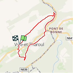
Ruta Senderismo de 5,9 km a descubrir en Valonia, Lieja, Marchin. Esta ruta ha sido propuesta por tourcondroz.
Descripción
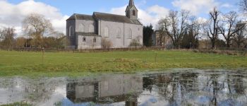
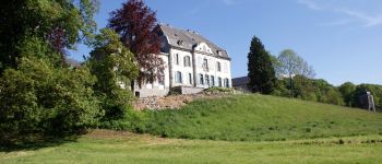
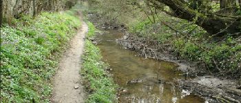
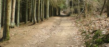
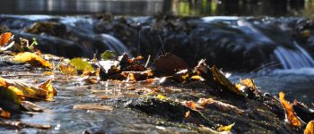
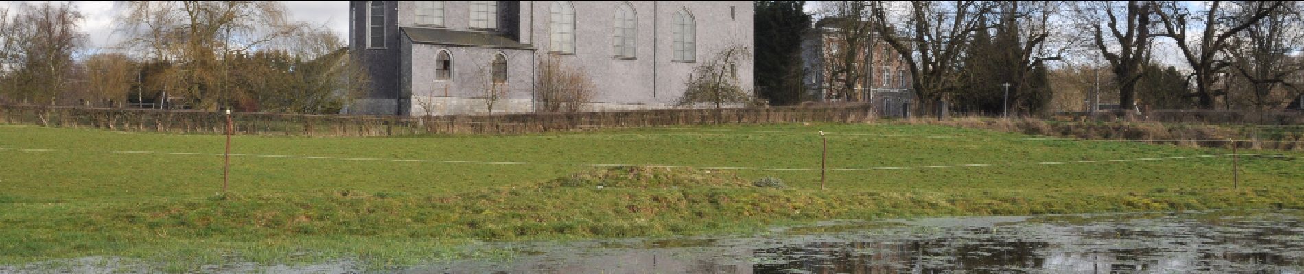
Au départ de l''ancienne école et maison communale de Vyle-Tharoul, cette promenade vous permettra de découvrir l''église Saint-Martin et le château de Vyle. Après cela, via un petit détour par le bois Guillaume, vous traverserez le sympathique village de Vyle avant de rejoindre la vallée du Hoyoux. Enfin, pour terminer cette charmante balade, vous regagnerez le point de départ à travers les campagnes.
Beau circuit composé de fortes côtes et descentes.
BALISE: losange rouge
Sources: Syndicat d''initiative de la Vallée du Hoyoux/Contrat Rivière Meuse-Aval/Pourvu que longtemps encore... Cr. photos : C. Robert - S. Pêcheur
Puntos de interés
Localización
Comentarios
Excursiones cerca
![Excursión Senderismo Clavier - RB-Lg-01 - Raccourci - Photo](https://media.geolcdn.com/t/375/260/ext.jpg?maxdim=2&url=https%3A%2F%2Fservices.sitytrail.com%2FGeolivesWS%2FDownloadMedia.ashx%3FTrailID%3D209390%26Media%3D22266d26-9089-4b3a-b5ae-a6da953afba4.jpg)
![Senderismo Senderismo](https://static1.geolcdn.com/sitytour/trail-icons/101.png)
Senderismo
![](/images/other/stat-length.png)
![](https://static1.geolcdn.com/siteimages/upload/files/16400158638029165_repeat_loop_refresh_sync_direction_icon.png)
![Excursión Senderismo Clavier - RB-Lg-01 - Dans les vallées du Hoyoux et du ruisseau de Pailhe - Photo](https://media.geolcdn.com/t/375/260/ext.jpg?maxdim=2&url=https%3A%2F%2Fservices.sitytrail.com%2FGeolivesWS%2FDownloadMedia.ashx%3FTrailID%3D179556%26Media%3D22266d26-9089-4b3a-b5ae-a6da953afba4.jpg)
![Senderismo Senderismo](https://static1.geolcdn.com/sitytour/trail-icons/101.png)
Senderismo
![](/images/other/stat-length.png)
![](https://static1.geolcdn.com/siteimages/upload/files/16400158638029165_repeat_loop_refresh_sync_direction_icon.png)
![Excursión Senderismo Modave - Modave. Natura 2000, des sites qui valent le détour ! Lg4 - Photo](https://media.geolcdn.com/t/375/260/ext.jpg?maxdim=2&url=https%3A%2F%2Fservices.sitytrail.com%2FGeolivesWS%2FDownloadMedia.ashx%3FTrailID%3D161410%26Media%3Dd7c559bb-fafd-4624-b5f1-8908c3c540dc.JPG)
![Senderismo Senderismo](https://static1.geolcdn.com/sitytour/trail-icons/101.png)
Senderismo
![](/images/other/stat-length.png)
![](https://static1.geolcdn.com/siteimages/upload/files/16400158638029165_repeat_loop_refresh_sync_direction_icon.png)
![Excursión Senderismo Ohey - OHEY- Evelette (Libois)- N° 13 Eau - Photo](https://media.geolcdn.com/t/375/260/ext.jpg?maxdim=2&url=https%3A%2F%2Fservices.sitytrail.com%2FGeolivesWS%2FDownloadMedia.ashx%3FTrailID%3D121420%26Media%3Dde7ff550-e553-4241-aaa7-7bac1b671239.jpg)
![Senderismo Senderismo](https://static1.geolcdn.com/sitytour/trail-icons/101.png)
Senderismo
![](/images/other/stat-length.png)
![](https://static1.geolcdn.com/siteimages/upload/files/16400158638029165_repeat_loop_refresh_sync_direction_icon.png)
![Excursión Senderismo Clavier - CLAVIER - La Romantique - Photo](https://media.geolcdn.com/t/375/260/ext.jpg?maxdim=2&url=https%3A%2F%2Fservices.sitytrail.com%2FGeolivesWS%2FDownloadMedia.ashx%3FTrailID%3D162888%26Media%3D9ae93777-447a-4289-aab4-f0814b4e414d.jpg)
![Senderismo Senderismo](https://static1.geolcdn.com/sitytour/trail-icons/101.png)
Senderismo
![](/images/other/stat-length.png)
![](https://static1.geolcdn.com/siteimages/upload/files/16400158638029165_repeat_loop_refresh_sync_direction_icon.png)
![Excursión Senderismo Marchin - MARCHIN - Chemin de la Mémoire - Photo](https://media.geolcdn.com/t/375/260/ext.jpg?maxdim=2&url=https%3A%2F%2Fservices.sitytrail.com%2FGeolivesWS%2FDownloadMedia.ashx%3FTrailID%3D134945%26Media%3D9baec6a8-ffff-4223-8cd2-41c1e7b6afda.jpg)
![Senderismo Senderismo](https://static1.geolcdn.com/sitytour/trail-icons/101.png)
Senderismo
![](/images/other/stat-length.png)
![](https://static1.geolcdn.com/siteimages/upload/files/16400158638029165_repeat_loop_refresh_sync_direction_icon.png)
![Excursión Senderismo Clavier - CLAVIER - Magnifique Hoyoux - Photo](https://media.geolcdn.com/t/375/260/ext.jpg?maxdim=2&url=https%3A%2F%2Fservices.sitytrail.com%2FGeolivesWS%2FDownloadMedia.ashx%3FTrailID%3D161792%26Media%3De8c9d35f-218b-443c-9500-f69ccd009442.jpg)
![Senderismo Senderismo](https://static1.geolcdn.com/sitytour/trail-icons/101.png)
Senderismo
![](/images/other/stat-length.png)
![](https://static1.geolcdn.com/siteimages/upload/files/16400158638029165_repeat_loop_refresh_sync_direction_icon.png)
![Excursión Senderismo Modave - Circuit de Petit-Modave - Modave(MD 01) - Photo](https://media.geolcdn.com/t/375/260/ext.jpg?maxdim=2&url=https%3A%2F%2Fservices.sitytrail.com%2FGeolivesWS%2FDownloadMedia.ashx%3FTrailID%3D211950%26Media%3D225bb37c-a1e6-4f9b-b5fa-27b4f60e72ba.JPG)
![Senderismo Senderismo](https://static1.geolcdn.com/sitytour/trail-icons/101.png)
Senderismo
![](/images/other/stat-length.png)
![](https://static1.geolcdn.com/siteimages/upload/files/16400158638029165_repeat_loop_refresh_sync_direction_icon.png)
![Excursión Senderismo Modave - Balade à Modave - Photo](https://media.geolcdn.com/t/375/260/efa446e4-aa4c-4b7a-afaa-1e1b5351db79.jpeg&format=jpg&maxdim=2)
![Senderismo Senderismo](https://static1.geolcdn.com/sitytour/trail-icons/101.png)
Senderismo
![](/images/other/stat-length.png)
![](https://static1.geolcdn.com/siteimages/upload/files/16400158638029165_repeat_loop_refresh_sync_direction_icon.png)
Chouette petite balade en nature ! Cependant, un peu trop de route à mon goût sur la fin.
très agréable promenade. village,bois,champs.