![](/images/other/stat-length.png)
![Excursión Senderismo Fontainebleau - GLM-120718 - HouxFranchard - Photo](https://media.geolcdn.com/t/1900/400/ext.pjpeg?maxdim=2&url=https%3A%2F%2Fservices.sitytrail.com%2FGeolivesWS%2FDownloadMedia.ashx%3FTrailID%3D139967%26Media%3D7a170b18-b892-4fb5-b858-f3224cc21841.jpg)
GLM-120718 - HouxFranchard
randodan
Usuario
![Longitud](/images/other/stat-length.png)
Longitud
14,7 km
![Altitud máxima](https://static1.geolcdn.com/siteimages/upload/files/1508320355ic_sort_altitude_max_24dp.png)
Altitud máxima
141 m
![Desnivel positivo](https://static1.geolcdn.com/siteimages/upload/files/1508320355ic_sort_den_pos_24dp.png)
Desnivel positivo
179 m
![Km-Effort](/images/other/stat-length.png)
Km-Effort
17,1 km
![Altitud mínima](https://static1.geolcdn.com/siteimages/upload/files/1508320355ic_sort_altitude_min_24dp.png)
Altitud mínima
90 m
![Desnivel negativo](https://static1.geolcdn.com/siteimages/upload/files/1508320355ic_sort_den_neg_24dp.png)
Desnivel negativo
181 m
![Boucle](https://static1.geolcdn.com/siteimages/upload/files/16400158638029165_repeat_loop_refresh_sync_direction_icon.png)
Boucle
Sí
Fecha de creación :
2014-12-10 00:00:00.0
Última modificación :
2014-12-10 00:00:00.0
![Senderismo](https://static1.geolcdn.com/sitytour/trail-icons/101.png)
6h35
Dificultad : Medio
![Escanee este código QR para abrir la excursión en la aplicación SityTrail](https://capi.geolives.com/qq0zvz2zws4bq2lad0pu/sitytour/trails/139967/qr.png?size=200)
Aplicación GPS de excursión GRATIS
A propósito
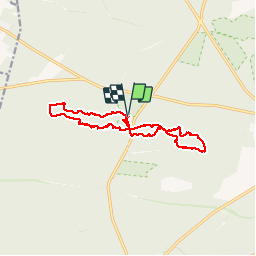
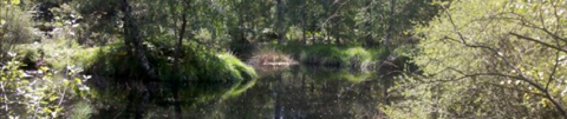
Ruta Senderismo de 14,7 km a descubrir en Isla de Francia, Sena y Marne, Fontainebleau. Esta ruta ha sido propuesta por randodan.
Descripción
Les Gais Lurons du Mercredi.
18 juillet 2012.
Départ parking Franchard.
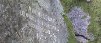
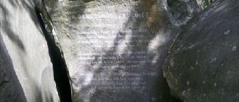
Platières des Gorges du Houx,
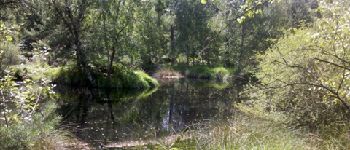
Mare aux Pigeons,
Gorges de Franchard.
Localización
País:
France
Región :
Isla de Francia
Departamento/provincia :
Sena y Marne
Municipio :
Fontainebleau
Localidad:
Unknown
Salida:(Dec)
Salida:(UTM)
473094 ; 5361826 (31U) N.
Comentarios
Excursiones cerca
![Excursión Senderismo Barbizon - Sentier des peintres - Photo](https://media.geolcdn.com/t/375/260/ext.jpg?maxdim=2&url=https%3A%2F%2Fservices.sitytrail.com%2FGeolivesWS%2FDownloadMedia.ashx%3FTrailID%3D188736%26Media%3D187396bd-9ee4-4169-9310-5793d2588587.jpeg)
![Senderismo Senderismo](https://static1.geolcdn.com/sitytour/trail-icons/101.png)
Sentier des peintres
Senderismo
Medio
(11)
Barbizon,
Isla de Francia,
Sena y Marne,
France
![](/images/other/stat-length.png)
7,5 km | 8,2 km-effort
1h 25min
![](https://static1.geolcdn.com/siteimages/upload/files/16400158638029165_repeat_loop_refresh_sync_direction_icon.png)
Sí
![Excursión Senderismo Fontainebleau - La Mare aux Fées 18km - Forêt de Fontainebleau - Photo](https://media.geolcdn.com/t/375/260/ext.jpg?maxdim=2&url=https%3A%2F%2Fstatic1.geolcdn.com%2Fsiteimages%2Fupload%2Ffiles%2F1553511878bg_sport_marche.png)
![Senderismo Senderismo](https://static1.geolcdn.com/sitytour/trail-icons/101.png)
La Mare aux Fées 18km - Forêt de Fontainebleau
Senderismo
Medio
(5)
Fontainebleau,
Isla de Francia,
Sena y Marne,
France
![](/images/other/stat-length.png)
18 km | 22 km-effort
4h 41min
![](https://static1.geolcdn.com/siteimages/upload/files/16400158638029165_repeat_loop_refresh_sync_direction_icon.png)
Sí
![Excursión A pie Fontainebleau - Boucle 28 km en forêt de Fontainebleau - Photo](https://media.geolcdn.com/t/375/260/21e3a864-d768-407e-8af1-222ee36d7889.jpg&format=jpg&maxdim=2)
![A pie A pie](https://static1.geolcdn.com/sitytour/trail-icons/100.png)
Boucle 28 km en forêt de Fontainebleau
A pie
Medio
(1)
Fontainebleau,
Isla de Francia,
Sena y Marne,
France
![](/images/other/stat-length.png)
28 km | 34 km-effort
7h 43min
![](https://static1.geolcdn.com/siteimages/upload/files/16400158638029165_repeat_loop_refresh_sync_direction_icon.png)
Sí
![Excursión Senderismo Fontainebleau - 3pi-150428 - DésertApremont-Jupiter - Photo](https://media.geolcdn.com/t/375/260/ext.jpg?maxdim=2&url=https%3A%2F%2Fservices.sitytrail.com%2FGeolivesWS%2FDownloadMedia.ashx%3FTrailID%3D414037%26Media%3D22942274-9308-46bb-bc6d-06c82c3e8751.jpg)
![Senderismo Senderismo](https://static1.geolcdn.com/sitytour/trail-icons/101.png)
3pi-150428 - DésertApremont-Jupiter
Senderismo
Fácil
(1)
Fontainebleau,
Isla de Francia,
Sena y Marne,
France
![](/images/other/stat-length.png)
16 km | 19,4 km-effort
6h 30min
![](https://static1.geolcdn.com/siteimages/upload/files/16400158638029165_repeat_loop_refresh_sync_direction_icon.png)
Sí
![Excursión Senderismo Fontainebleau - Rando mares aux fees Gilles18 km - Photo](https://media.geolcdn.com/t/375/260/1a2c21e9-241f-4517-a09c-d9710ae3d7d2.jpg&format=jpg&maxdim=2)
![Senderismo Senderismo](https://static1.geolcdn.com/sitytour/trail-icons/101.png)
Rando mares aux fees Gilles18 km
Senderismo
Muy difícil
(1)
Fontainebleau,
Isla de Francia,
Sena y Marne,
France
![](/images/other/stat-length.png)
17,8 km | 22 km-effort
4h 58min
![](https://static1.geolcdn.com/siteimages/upload/files/16400158638029165_repeat_loop_refresh_sync_direction_icon.png)
Sí
![Excursión Senderismo Fontainebleau - Boucle du Château de Fontainebleau à Thomery 21 km - Photo](https://media.geolcdn.com/t/375/260/22a500a3-91bf-4087-9234-7c012b4b260f.jpg&format=jpg&maxdim=2)
![Senderismo Senderismo](https://static1.geolcdn.com/sitytour/trail-icons/101.png)
Boucle du Château de Fontainebleau à Thomery 21 km
Senderismo
Medio
Fontainebleau,
Isla de Francia,
Sena y Marne,
France
![](/images/other/stat-length.png)
21 km | 24 km-effort
4h 27min
![](https://static1.geolcdn.com/siteimages/upload/files/16400158638029165_repeat_loop_refresh_sync_direction_icon.png)
Sí
![Excursión Senderismo Fontainebleau - Boucle Barbizon - Arbonne 26 km - Photo](https://media.geolcdn.com/t/375/260/d3a133ff-ea77-47a6-826a-54bbe45391c4.jpg&format=jpg&maxdim=2)
![Senderismo Senderismo](https://static1.geolcdn.com/sitytour/trail-icons/101.png)
Boucle Barbizon - Arbonne 26 km
Senderismo
Medio
Fontainebleau,
Isla de Francia,
Sena y Marne,
France
![](/images/other/stat-length.png)
26 km | 30 km-effort
5h 6min
![](https://static1.geolcdn.com/siteimages/upload/files/16400158638029165_repeat_loop_refresh_sync_direction_icon.png)
Sí
![Excursión Senderismo Fontainebleau - Sentier Denecourt N°9 Rocher des Demoiselles - Photo](https://media.geolcdn.com/t/375/260/ext.jpg?maxdim=2&url=https%3A%2F%2Fstatic1.geolcdn.com%2Fsiteimages%2Fupload%2Ffiles%2F1553511878bg_sport_marche.png)
![Senderismo Senderismo](https://static1.geolcdn.com/sitytour/trail-icons/101.png)
Sentier Denecourt N°9 Rocher des Demoiselles
Senderismo
Medio
(1)
Fontainebleau,
Isla de Francia,
Sena y Marne,
France
![](/images/other/stat-length.png)
5 km | 6,3 km-effort
1h 25min
![](https://static1.geolcdn.com/siteimages/upload/files/16400158638029165_repeat_loop_refresh_sync_direction_icon.png)
Sí
![Excursión Senderismo Fontainebleau - SityTrail - JC 71 Fontainebleau Rocher Cassepot, Tour Denecourt - Photo](https://media.geolcdn.com/t/375/260/ext.jpg?maxdim=2&url=https%3A%2F%2Fstatic1.geolcdn.com%2Fsiteimages%2Fupload%2Ffiles%2F1553511878bg_sport_marche.png)
![Senderismo Senderismo](https://static1.geolcdn.com/sitytour/trail-icons/101.png)
SityTrail - JC 71 Fontainebleau Rocher Cassepot, Tour Denecourt
Senderismo
Difícil
(1)
Fontainebleau,
Isla de Francia,
Sena y Marne,
France
![](/images/other/stat-length.png)
16,9 km | 22 km-effort
4h 55min
![](https://static1.geolcdn.com/siteimages/upload/files/16400158638029165_repeat_loop_refresh_sync_direction_icon.png)
Sí