![](/images/other/stat-length.png)
![Excursión Senderismo Guérande - 20120717-SAUDUN - Photo](https://media.geolcdn.com/t/1900/400/ext.pjpeg?maxdim=2&url=https%3A%2F%2Fstatic1.geolcdn.com%2Fsiteimages%2Fupload%2Ffiles%2F1553511878bg_sport_marche.png)
20120717-SAUDUN
BVB
Usuario
![Longitud](/images/other/stat-length.png)
Longitud
13,8 km
![Altitud máxima](https://static1.geolcdn.com/siteimages/upload/files/1508320355ic_sort_altitude_max_24dp.png)
Altitud máxima
22 m
![Desnivel positivo](https://static1.geolcdn.com/siteimages/upload/files/1508320355ic_sort_den_pos_24dp.png)
Desnivel positivo
89 m
![Km-Effort](/images/other/stat-length.png)
Km-Effort
15 km
![Altitud mínima](https://static1.geolcdn.com/siteimages/upload/files/1508320355ic_sort_altitude_min_24dp.png)
Altitud mínima
-3 m
![Desnivel negativo](https://static1.geolcdn.com/siteimages/upload/files/1508320355ic_sort_den_neg_24dp.png)
Desnivel negativo
89 m
![Boucle](https://static1.geolcdn.com/siteimages/upload/files/16400158638029165_repeat_loop_refresh_sync_direction_icon.png)
Boucle
Sí
Fecha de creación :
2014-12-10 00:00:00.0
Última modificación :
2014-12-10 00:00:00.0
![Senderismo](https://static1.geolcdn.com/sitytour/trail-icons/101.png)
3h16
Dificultad : Fácil
![Escanee este código QR para abrir la excursión en la aplicación SityTrail](https://capi.geolives.com/qq0zvz2zws4bq2lad0pu/sitytour/trails/139710/qr.png?size=200)
Aplicación GPS de excursión GRATIS
A propósito
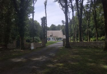
Ruta Senderismo de 13,8 km a descubrir en Países del Loira, Loira-Atlántico, Guérande. Esta ruta ha sido propuesta por BVB.
Descripción
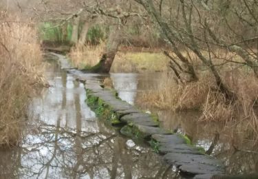
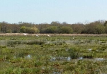
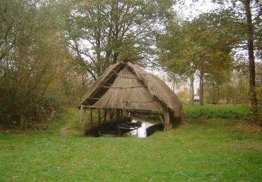
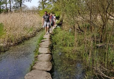
Très belle promenade le long du marais de Brière.
Attention, prévoir chaussures de marche, pantalon, et protection contre les moustiques et autres insectes.
Localización
País:
France
Región :
Países del Loira
Departamento/provincia :
Loira-Atlántico
Municipio :
Guérande
Localidad:
Unknown
Salida:(Dec)
Salida:(UTM)
549945 ; 5244366 (30T) N.
Comentarios
Excursiones cerca
![Excursión Senderismo Saint-André-des-Eaux - Sentier Terre Brière - Photo](https://media.geolcdn.com/t/375/260/ext.jpg?maxdim=2&url=https%3A%2F%2Fstatic1.geolcdn.com%2Fsiteimages%2Fupload%2Ffiles%2F1553511878bg_sport_marche.png)
![Senderismo Senderismo](https://static1.geolcdn.com/sitytour/trail-icons/101.png)
Sentier Terre Brière
Senderismo
Fácil
(3)
Saint-André-des-Eaux,
Países del Loira,
Loira-Atlántico,
France
![](/images/other/stat-length.png)
13,7 km | 14,7 km-effort
3h 15min
![](https://static1.geolcdn.com/siteimages/upload/files/16400158638029165_repeat_loop_refresh_sync_direction_icon.png)
Sí
![Excursión Senderismo Saint-Lyphard - boucle chaumières et marais - Photo](https://media.geolcdn.com/t/375/260/18cff159-7406-4d5c-843f-566a057e4731.jpg&format=jpg&maxdim=2)
![Senderismo Senderismo](https://static1.geolcdn.com/sitytour/trail-icons/101.png)
boucle chaumières et marais
Senderismo
Fácil
(1)
Saint-Lyphard,
Países del Loira,
Loira-Atlántico,
France
![](/images/other/stat-length.png)
10,7 km | 11,6 km-effort
2h 24min
![](https://static1.geolcdn.com/siteimages/upload/files/16400158638029165_repeat_loop_refresh_sync_direction_icon.png)
Sí
![Excursión Senderismo Saint-Lyphard - Bréca - Brière sud-ouest - Photo](https://media.geolcdn.com/t/375/260/ext.jpg?maxdim=2&url=https%3A%2F%2Fservices.sitytrail.com%2FGeolivesWS%2FDownloadMedia.ashx%3FTrailID%3D407129%26Media%3Dfix__20150412161425.jpg)
![Senderismo Senderismo](https://static1.geolcdn.com/sitytour/trail-icons/101.png)
Bréca - Brière sud-ouest
Senderismo
Fácil
Saint-Lyphard,
Países del Loira,
Loira-Atlántico,
France
![](/images/other/stat-length.png)
16,1 km | 17,6 km-effort
3h 53min
![](https://static1.geolcdn.com/siteimages/upload/files/16400158638029165_repeat_loop_refresh_sync_direction_icon.png)
Sí
![Excursión Senderismo Saint-Lyphard - Port de Bréca - Marais de la Brière - Photo](https://media.geolcdn.com/t/375/260/ext.jpg?maxdim=2&url=https%3A%2F%2Fservices.sitytrail.com%2FGeolivesWS%2FDownloadMedia.ashx%3FTrailID%3D101735%26Media%3D1983_4.jpg)
![Senderismo Senderismo](https://static1.geolcdn.com/sitytour/trail-icons/101.png)
Port de Bréca - Marais de la Brière
Senderismo
Fácil
(2)
Saint-Lyphard,
Países del Loira,
Loira-Atlántico,
France
![](/images/other/stat-length.png)
5,2 km | 5,6 km-effort
1h 30min
![](https://static1.geolcdn.com/siteimages/upload/files/16400158638029165_repeat_loop_refresh_sync_direction_icon.png)
Sí
![Excursión Senderismo Saint-Lyphard - 2023-07-29 Brèca -st lyphar - Photo](https://media.geolcdn.com/t/375/260/15f941d4-f918-441f-abd0-3875ad834d66.jpg&format=jpg&maxdim=2)
![Senderismo Senderismo](https://static1.geolcdn.com/sitytour/trail-icons/101.png)
2023-07-29 Brèca -st lyphar
Senderismo
Medio
Saint-Lyphard,
Países del Loira,
Loira-Atlántico,
France
![](/images/other/stat-length.png)
16,5 km | 18 km-effort
3h 32min
![](https://static1.geolcdn.com/siteimages/upload/files/16400158638029165_repeat_loop_refresh_sync_direction_icon.png)
Sí
![Excursión Senderismo Saint-Lyphard - SAINT-LYPHARD_01_KERHINET_L'EGUIGNAC_20180422 - Photo](https://media.geolcdn.com/t/375/260/ext.jpg?maxdim=2&url=https%3A%2F%2Fservices.sitytrail.com%2FGeolivesWS%2FDownloadMedia.ashx%3FTrailID%3D948907%26Media%3Dfix__20180422144233.jpg)
![Senderismo Senderismo](https://static1.geolcdn.com/sitytour/trail-icons/101.png)
SAINT-LYPHARD_01_KERHINET_L'EGUIGNAC_20180422
Senderismo
Muy fácil
Saint-Lyphard,
Países del Loira,
Loira-Atlántico,
France
![](/images/other/stat-length.png)
12 km | 13,1 km-effort
2h 53min
![](https://static1.geolcdn.com/siteimages/upload/files/16400158638029165_repeat_loop_refresh_sync_direction_icon.png)
Sí
![Excursión Senderismo Saint-André-des-Eaux - Saint André des Eaux - Photo](https://media.geolcdn.com/t/375/260/ext.jpg?maxdim=2&url=https%3A%2F%2Fstatic1.geolcdn.com%2Fsiteimages%2Fupload%2Ffiles%2F1553511878bg_sport_marche.png)
![Senderismo Senderismo](https://static1.geolcdn.com/sitytour/trail-icons/101.png)
Saint André des Eaux
Senderismo
Medio
Saint-André-des-Eaux,
Países del Loira,
Loira-Atlántico,
France
![](/images/other/stat-length.png)
7,9 km | 8,3 km-effort
1h 53min
![](https://static1.geolcdn.com/siteimages/upload/files/16400158638029165_repeat_loop_refresh_sync_direction_icon.png)
Sí
![Excursión Senderismo Saint-André-des-Eaux - trehe - Photo](https://media.geolcdn.com/t/375/260/ext.jpg?maxdim=2&url=https%3A%2F%2Fstatic1.geolcdn.com%2Fsiteimages%2Fupload%2Ffiles%2F1553511878bg_sport_marche.png)
![Senderismo Senderismo](https://static1.geolcdn.com/sitytour/trail-icons/101.png)
trehe
Senderismo
Medio
Saint-André-des-Eaux,
Países del Loira,
Loira-Atlántico,
France
![](/images/other/stat-length.png)
7,3 km | 8,2 km-effort
1h 41min
![](https://static1.geolcdn.com/siteimages/upload/files/16400158638029165_repeat_loop_refresh_sync_direction_icon.png)
Sí
![Excursión Bicicleta híbrida Saint-André-des-Eaux - saint André - Photo](https://media.geolcdn.com/t/375/260/ext.jpg?maxdim=2&url=https%3A%2F%2Fstatic1.geolcdn.com%2Fsiteimages%2Fupload%2Ffiles%2F1524743154velo.jpg)
![Bicicleta híbrida Bicicleta híbrida](https://static1.geolcdn.com/sitytour/trail-icons/203.png)
saint André
Bicicleta híbrida
Fácil
Saint-André-des-Eaux,
Países del Loira,
Loira-Atlántico,
France
![](/images/other/stat-length.png)
9,3 km | 10,1 km-effort
50min
![](https://static1.geolcdn.com/siteimages/upload/files/16400158638029165_repeat_loop_refresh_sync_direction_icon.png)
No