![](/images/other/stat-length.png)
![Excursión Senderismo Courgoul - Courgoul - Bergère - Photo](https://media.geolcdn.com/t/1900/400/ext.pjpeg?maxdim=2&url=https%3A%2F%2Fservices.sitytrail.com%2FGeolivesWS%2FDownloadMedia.ashx%3FTrailID%3D136868%26Media%3D13536_4.jpg)
Courgoul - Bergère
tracegps
Usuario
![Longitud](/images/other/stat-length.png)
![Altitud máxima](https://static1.geolcdn.com/siteimages/upload/files/1508320355ic_sort_altitude_max_24dp.png)
![Desnivel positivo](https://static1.geolcdn.com/siteimages/upload/files/1508320355ic_sort_den_pos_24dp.png)
![Km-Effort](/images/other/stat-length.png)
![Altitud mínima](https://static1.geolcdn.com/siteimages/upload/files/1508320355ic_sort_altitude_min_24dp.png)
![Desnivel negativo](https://static1.geolcdn.com/siteimages/upload/files/1508320355ic_sort_den_neg_24dp.png)
![Boucle](https://static1.geolcdn.com/siteimages/upload/files/16400158638029165_repeat_loop_refresh_sync_direction_icon.png)
![Senderismo](https://static1.geolcdn.com/sitytour/trail-icons/101.png)
3h00
Dificultad : Difícil
![Escanee este código QR para abrir la excursión en la aplicación SityTrail](https://capi.geolives.com/qq0zvz2zws4bq2lad0pu/sitytour/trails/136868/qr.png?size=200)
Aplicación GPS de excursión GRATIS
A propósito
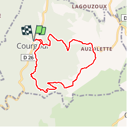
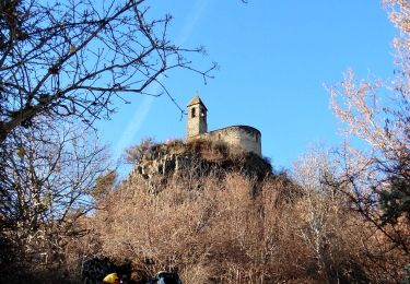
Ruta Senderismo de 7,5 km a descubrir en Auvergne-Rhône-Alpes, Puy-de-Dôme, Courgoul. Esta ruta ha sido propuesta por tracegps.
Descripción
Départ à l'entrée de Courgoul (deux autres randonnées possibles). Balade pas très longue mais physique: 450 mètres de dénivelé sur 3 km. Après avoir cheminé en sous bois, on arrive sur un plateau offrant de très belles vues. On rejoint Courgoul par un large chemin.
Localización
Comentarios
Excursiones cerca
![Excursión A pie Dauzat-sur-Vodable - Dauzat-sur-Vodable - Photo](https://media.geolcdn.com/t/375/260/d172e481-65da-4881-bd03-f6cc99def315.jpeg&format=jpg&maxdim=2)
![A pie A pie](https://static1.geolcdn.com/sitytour/trail-icons/100.png)
A pie
![](/images/other/stat-length.png)
![](https://static1.geolcdn.com/siteimages/upload/files/16400158638029165_repeat_loop_refresh_sync_direction_icon.png)
![Excursión A pie Saint-Diéry - Le Cheix - Photo](https://media.geolcdn.com/t/375/260/cef373ab-41f4-493d-8694-97c838874352.jpeg&format=jpg&maxdim=2)
![A pie A pie](https://static1.geolcdn.com/sitytour/trail-icons/100.png)
A pie
![](/images/other/stat-length.png)
![](https://static1.geolcdn.com/siteimages/upload/files/16400158638029165_repeat_loop_refresh_sync_direction_icon.png)
![Excursión A pie Valbeleix - Le Plateau de la Chavade et la Roche Nite - Photo](https://media.geolcdn.com/t/375/260/a467407f-a0fb-4883-8852-b6255f6151df.jpeg&format=jpg&maxdim=2)
![A pie A pie](https://static1.geolcdn.com/sitytour/trail-icons/100.png)
A pie
![](/images/other/stat-length.png)
![](https://static1.geolcdn.com/siteimages/upload/files/16400158638029165_repeat_loop_refresh_sync_direction_icon.png)
![Excursión A pie Saurier - Le Pic de Brionnet - Photo](https://media.geolcdn.com/t/375/260/6e33ab27-c788-4f32-8c30-5bc1de6dd66f.jpeg&format=jpg&maxdim=2)
![A pie A pie](https://static1.geolcdn.com/sitytour/trail-icons/100.png)
A pie
![](/images/other/stat-length.png)
![](https://static1.geolcdn.com/siteimages/upload/files/16400158638029165_repeat_loop_refresh_sync_direction_icon.png)
![Excursión Senderismo Courgoul - Les-Gorges-de-Courgoul-Marcenat_T - Photo](https://media.geolcdn.com/t/375/260/78d4684c-2220-458c-aac4-f2b1ac8cba79.jpg&format=jpg&maxdim=2)
![Senderismo Senderismo](https://static1.geolcdn.com/sitytour/trail-icons/101.png)
Senderismo
![](/images/other/stat-length.png)
![](https://static1.geolcdn.com/siteimages/upload/files/16400158638029165_repeat_loop_refresh_sync_direction_icon.png)
![Excursión Senderismo Saint-Diéry - St_Diery_Mont_Carmel - Photo](https://media.geolcdn.com/t/375/260/3e3b4de8-74a3-4fde-8693-784ab1979488.jpg&format=jpg&maxdim=2)
![Senderismo Senderismo](https://static1.geolcdn.com/sitytour/trail-icons/101.png)
Senderismo
![](/images/other/stat-length.png)
![](https://static1.geolcdn.com/siteimages/upload/files/16400158638029165_repeat_loop_refresh_sync_direction_icon.png)
![Excursión A pie Saint-Diéry - Cotteuge - Photo](https://media.geolcdn.com/t/375/260/cef373ab-41f4-493d-8694-97c838874352.jpeg&format=jpg&maxdim=2)
![A pie A pie](https://static1.geolcdn.com/sitytour/trail-icons/100.png)
A pie
![](/images/other/stat-length.png)
![](https://static1.geolcdn.com/siteimages/upload/files/16400158638029165_repeat_loop_refresh_sync_direction_icon.png)
![Excursión A pie Chassagne - Le Plateau d'Ussel - Photo](https://media.geolcdn.com/t/375/260/56405ee6-4d93-4498-a458-c552d564104f.jpeg&format=jpg&maxdim=2)
![A pie A pie](https://static1.geolcdn.com/sitytour/trail-icons/100.png)
A pie
![](/images/other/stat-length.png)
![](https://static1.geolcdn.com/siteimages/upload/files/16400158638029165_repeat_loop_refresh_sync_direction_icon.png)
![Excursión Senderismo Saurier - Saurier-Brionnet_T - Photo](https://media.geolcdn.com/t/375/260/ba5c2247-984d-4737-ae94-96b595088246.jpg&format=jpg&maxdim=2)
![Senderismo Senderismo](https://static1.geolcdn.com/sitytour/trail-icons/101.png)
Senderismo
![](/images/other/stat-length.png)
![](https://static1.geolcdn.com/siteimages/upload/files/16400158638029165_repeat_loop_refresh_sync_direction_icon.png)