![](/images/other/stat-length.png)
![Excursión Bici de montaña Westhalten - Westhalten - Grand Ballon - Nez de Soultz - Photo](https://media.geolcdn.com/t/1900/400/ext.pjpeg?maxdim=2&url=https%3A%2F%2Fstatic1.geolcdn.com%2Fsiteimages%2Fupload%2Ffiles%2F1524743154velo.jpg)
Westhalten - Grand Ballon - Nez de Soultz
pgrimm
Usuario
![Longitud](/images/other/stat-length.png)
Longitud
46 km
![Altitud máxima](https://static1.geolcdn.com/siteimages/upload/files/1508320355ic_sort_altitude_max_24dp.png)
Altitud máxima
1420 m
![Desnivel positivo](https://static1.geolcdn.com/siteimages/upload/files/1508320355ic_sort_den_pos_24dp.png)
Desnivel positivo
1587 m
![Km-Effort](/images/other/stat-length.png)
Km-Effort
67 km
![Altitud mínima](https://static1.geolcdn.com/siteimages/upload/files/1508320355ic_sort_altitude_min_24dp.png)
Altitud mínima
230 m
![Desnivel negativo](https://static1.geolcdn.com/siteimages/upload/files/1508320355ic_sort_den_neg_24dp.png)
Desnivel negativo
1591 m
![Boucle](https://static1.geolcdn.com/siteimages/upload/files/16400158638029165_repeat_loop_refresh_sync_direction_icon.png)
Boucle
Sí
Fecha de creación :
2016-04-03 00:00:00.0
Última modificación :
2016-04-03 00:00:00.0
![Bici de montaña](https://static1.geolcdn.com/sitytour/trail-icons/202.png)
4h14
Dificultad : Difícil
![Escanee este código QR para abrir la excursión en la aplicación SityTrail](https://capi.geolives.com/qq0zvz2zws4bq2lad0pu/sitytour/trails/130918/qr.png?size=200)
Aplicación GPS de excursión GRATIS
A propósito
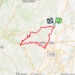
Ruta Bici de montaña de 46 km a descubrir en Gran Este, Alto Rin, Westhalten. Esta ruta ha sido propuesta por pgrimm.
Descripción
Départ de Westhalten. 22 km jusqu'au Grand Ballon, 13 km de descente sur Guebwiller puis retour par le vignoble.
Localización
País:
France
Región :
Gran Este
Departamento/provincia :
Alto Rin
Municipio :
Westhalten
Localidad:
Unknown
Salida:(Dec)
Salida:(UTM)
370025 ; 5313088 (32T) N.
Comentarios
Excursiones cerca
![Excursión Senderismo Westhalten - 2021 03 04 Westhalten - Photo](https://media.geolcdn.com/t/375/260/227de508-d68e-430e-b1c3-67de94c52b45.jpg&format=jpg&maxdim=2)
![Senderismo Senderismo](https://static1.geolcdn.com/sitytour/trail-icons/101.png)
2021 03 04 Westhalten
Senderismo
Fácil
(1)
Westhalten,
Gran Este,
Alto Rin,
France
![](/images/other/stat-length.png)
7,7 km | 11,3 km-effort
2h 21min
![](https://static1.geolcdn.com/siteimages/upload/files/16400158638029165_repeat_loop_refresh_sync_direction_icon.png)
Sí
![Senderismo Senderismo](https://static1.geolcdn.com/sitytour/trail-icons/101.png)
Osenbach - Sentier des Sols
Senderismo
Fácil
(1)
Osenbach,
Gran Este,
Alto Rin,
France
![](/images/other/stat-length.png)
4,7 km | 6,6 km-effort
3h 0min
![](https://static1.geolcdn.com/siteimages/upload/files/16400158638029165_repeat_loop_refresh_sync_direction_icon.png)
Sí
![Excursión Senderismo Rouffach - SityTrail - Rouffach vers Schauenberg variante - Photo](https://media.geolcdn.com/t/375/260/ext.jpg?maxdim=2&url=https%3A%2F%2Fstatic1.geolcdn.com%2Fsiteimages%2Fupload%2Ffiles%2F1553511878bg_sport_marche.png)
![Senderismo Senderismo](https://static1.geolcdn.com/sitytour/trail-icons/101.png)
SityTrail - Rouffach vers Schauenberg variante
Senderismo
Fácil
(1)
Rouffach,
Gran Este,
Alto Rin,
France
![](/images/other/stat-length.png)
10,6 km | 15,3 km-effort
3h 29min
![](https://static1.geolcdn.com/siteimages/upload/files/16400158638029165_repeat_loop_refresh_sync_direction_icon.png)
Sí
![Excursión Senderismo Westhalten - ND du Hubel_Schauenberg - Photo](https://media.geolcdn.com/t/375/260/ext.jpg?maxdim=2&url=https%3A%2F%2Fstatic1.geolcdn.com%2Fsiteimages%2Fupload%2Ffiles%2F1553511878bg_sport_marche.png)
![Senderismo Senderismo](https://static1.geolcdn.com/sitytour/trail-icons/101.png)
ND du Hubel_Schauenberg
Senderismo
Medio
(2)
Westhalten,
Gran Este,
Alto Rin,
France
![](/images/other/stat-length.png)
8,3 km | 11,7 km-effort
2h 39min
![](https://static1.geolcdn.com/siteimages/upload/files/16400158638029165_repeat_loop_refresh_sync_direction_icon.png)
Sí
![Excursión Senderismo Pfaffenheim - Schauenberg 1 - Photo](https://media.geolcdn.com/t/375/260/ext.jpg?maxdim=2&url=https%3A%2F%2Fstatic1.geolcdn.com%2Fsiteimages%2Fupload%2Ffiles%2F1553511878bg_sport_marche.png)
![Senderismo Senderismo](https://static1.geolcdn.com/sitytour/trail-icons/101.png)
Schauenberg 1
Senderismo
Fácil
(1)
Pfaffenheim,
Gran Este,
Alto Rin,
France
![](/images/other/stat-length.png)
10,3 km | 16,5 km-effort
3h 30min
![](https://static1.geolcdn.com/siteimages/upload/files/16400158638029165_repeat_loop_refresh_sync_direction_icon.png)
Sí
![Excursión Bici de montaña Westhalten - Westhalten - Le tour de la vallée Noble - Photo](https://media.geolcdn.com/t/375/260/ext.jpg?maxdim=2&url=https%3A%2F%2Fstatic1.geolcdn.com%2Fsiteimages%2Fupload%2Ffiles%2F1524743154velo.jpg)
![Bici de montaña Bici de montaña](https://static1.geolcdn.com/sitytour/trail-icons/202.png)
Westhalten - Le tour de la vallée Noble
Bici de montaña
Difícil
(1)
Westhalten,
Gran Este,
Alto Rin,
France
![](/images/other/stat-length.png)
24 km | 33 km-effort
2h 30min
![](https://static1.geolcdn.com/siteimages/upload/files/16400158638029165_repeat_loop_refresh_sync_direction_icon.png)
Sí
![Excursión Senderismo Pfaffenheim - Marche TL 10/2024 - Parking Chataignier- ND du Schauenburg-Rocher du Coucou-Carrières de Gueberschwihr-Sentier de découvertes- Taverne médiévale-Chapelle St Léonard et retour - Photo](https://media.geolcdn.com/t/375/260/ext.jpg?maxdim=2&url=https%3A%2F%2Fstatic1.geolcdn.com%2Fsiteimages%2Fupload%2Ffiles%2F1553511878bg_sport_marche.png)
![Senderismo Senderismo](https://static1.geolcdn.com/sitytour/trail-icons/101.png)
Marche TL 10/2024 - Parking Chataignier- ND du Schauenburg-Rocher du Coucou-C...
Senderismo
Difícil
(1)
Pfaffenheim,
Gran Este,
Alto Rin,
France
![](/images/other/stat-length.png)
8,5 km | 12,5 km-effort
2h 50min
![](https://static1.geolcdn.com/siteimages/upload/files/16400158638029165_repeat_loop_refresh_sync_direction_icon.png)
Sí
![Excursión Senderismo Westhalten - WESTHALTEN ZINKOEPHLE - Photo](https://media.geolcdn.com/t/375/260/bb43cbf9-190d-4da9-9235-1bfdec11bc91.jpg&format=jpg&maxdim=2)
![Senderismo Senderismo](https://static1.geolcdn.com/sitytour/trail-icons/101.png)
WESTHALTEN ZINKOEPHLE
Senderismo
Medio
Westhalten,
Gran Este,
Alto Rin,
France
![](/images/other/stat-length.png)
10,6 km | 15,3 km-effort
2h 56min
![](https://static1.geolcdn.com/siteimages/upload/files/16400158638029165_repeat_loop_refresh_sync_direction_icon.png)
Sí
![Excursión Senderismo Westhalten - Westhalten - Rouffach - Photo](https://media.geolcdn.com/t/375/260/573d5f52-f23d-4aea-a093-7c17bce8a144.jpg&format=jpg&maxdim=2)
![Senderismo Senderismo](https://static1.geolcdn.com/sitytour/trail-icons/101.png)
Westhalten - Rouffach
Senderismo
Difícil
Westhalten,
Gran Este,
Alto Rin,
France
![](/images/other/stat-length.png)
8,9 km | 13 km-effort
3h 22min
![](https://static1.geolcdn.com/siteimages/upload/files/16400158638029165_repeat_loop_refresh_sync_direction_icon.png)
Sí